fountainguy97
-
Posts
1,267 -
Joined
-
Last visited
Content Type
Profiles
Blogs
Forums
American Weather
Media Demo
Store
Gallery
Everything posted by fountainguy97
-

January 2026 Short/Medium Range Thread
fountainguy97 replied to John1122's topic in Tennessee Valley
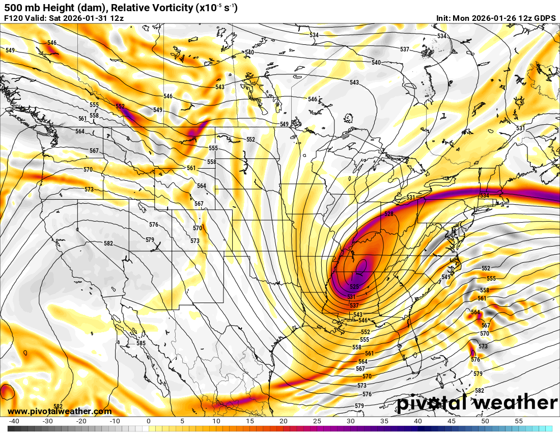
Yep. Models at 12z did tick back east a good bit. EPS did pretty significantly. the "good" news is the weathernext model is pretty far east but has some ULL enhancement on our side the apps still. And with rations up toward 20:1 it won't take much. -
January 2026 Short/Medium Range Thread
fountainguy97 replied to John1122's topic in Tennessee Valley
-
January 2026 Short/Medium Range Thread
fountainguy97 replied to John1122's topic in Tennessee Valley
the CMC is about to drop a nuke. it was the first model to show the WAA last week -
January 2026 Short/Medium Range Thread
fountainguy97 replied to John1122's topic in Tennessee Valley
Honestly we need some ticks for a deeper dive. Euro already is ticking north. Sure the west trend is good but a north trend is not. -
January 2026 Short/Medium Range Thread
fountainguy97 replied to John1122's topic in Tennessee Valley
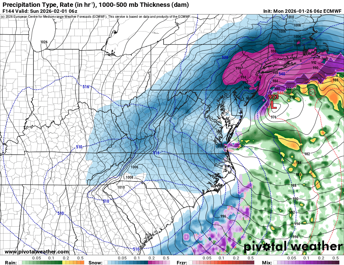
That second push into ETN at end of run was going to be laying it down heavy. We are at the timeframe where the last storm "jumped." So to see this one jump from out to sea to an actual threat gives some legitimacy to our chances. The Google model was killer. We need to follow it. It's still suppressed somewhat. I got burned telling some friends about the last one. This one my mouth is SHUT lol. -
January 2026 Short/Medium Range Thread
fountainguy97 replied to John1122's topic in Tennessee Valley
Yes it has. ETN is just on the fringe. Really could use it a bit more west and south. Not sure we will get that. -
January 2026 Short/Medium Range Thread
fountainguy97 replied to John1122's topic in Tennessee Valley
I will not get excited. I will not get excited. I will not get excited. I will no get excited. I will not get excited. I will not get excited. just absurd soundings for east tn.. ratios are 25:1+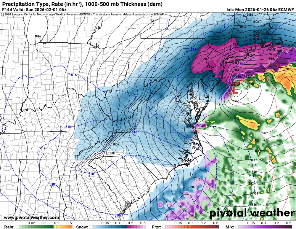
-
January 2026 Short/Medium Range Thread
fountainguy97 replied to John1122's topic in Tennessee Valley
Atleast this one is suppressed at this range. We can deal with that. -
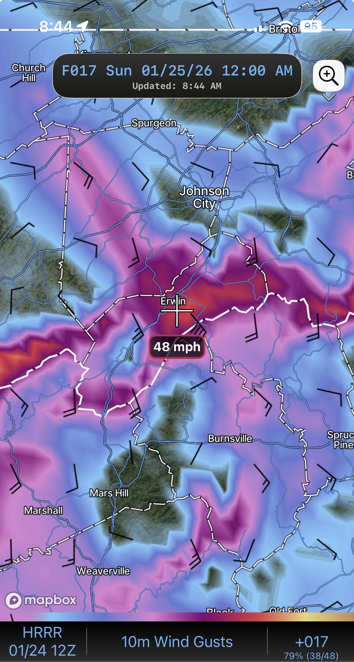
We dodged a major bullet across Unicoi county last night. Much warmer than modeled. (The CAD downsloping fingers never really helped much). Most of my glaze is gone. But I've had several wind gusts at 30mph this morning and my Davis is fairly well protected from this direction of wind. It's ripping.
- 618 replies
-
- 3
-

-
- observations
- obs thread
- (and 1 more)
-
The CAD is just starting to push along the the TN/NC border. So the next 2 hours we should see that occur. I'm at 30.9/18.6 and am supposed to be dead center that cold streak in Unicoi/Erwin.
-
31/18 mix of sleet and flakes. My driveway is already covered. Ground is frozen. winds picking up and models showing .3-.4 zr with 30-50mph winds. Going to be an interesting night.
- 618 replies
-
- 1
-
-
- observations
- obs thread
- (and 1 more)
-
Hrrr near term trending colder each run. No surprise, I think the nam and fv3 thermals will be closer to reality.
-
Yeah that's my guess too. The hrrr gives me .25-.3 but the other high res are much higher.
-
hoping to dodge a bullet here. High-res models have some 35-50 mph gusts here during and after the freezing rain. Thankfully the zr amounts arnt scary high on high res. But wouldn't take much.

-
lol. A 67 page thread for this type of forecast.. One thing this storm has done is created a very hostile environment on Facebook for any meteorologist. The comments under this are just sad honestly.

-
The valley wouldn't see as big of a warm surge. But I don't think we avoid the apps runner. But it also won't cut through middle TN
-
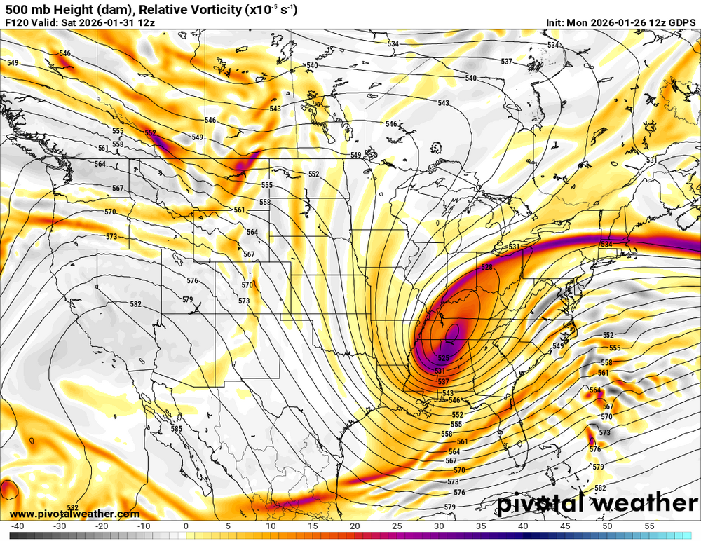
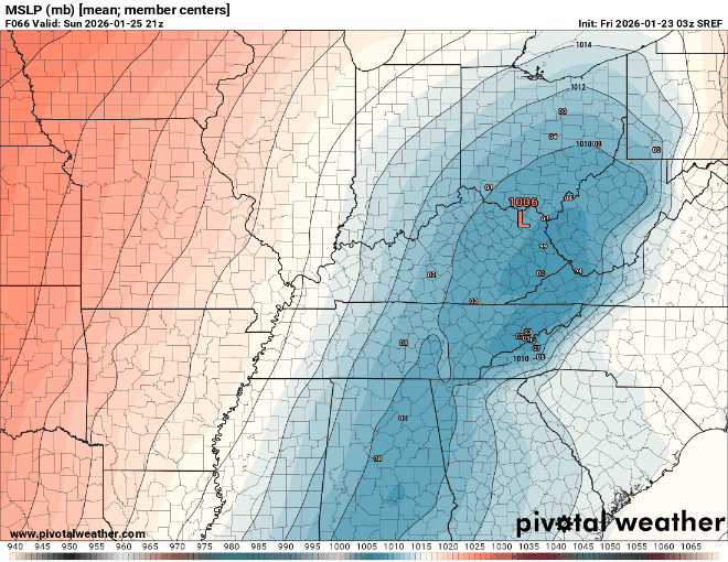
Not sure if this means much for 00z but sref is coming south. we are not too far from possibly getting this thing south of the mountains. But my gut tells me we won't quite make it and it'll ride the apps
-
Showers may get COLD lol
-
Our cooking and heat source is propane. I've got a small briefcase inverter generator for small stuff. Can even run a crockpot off it. if we were out of power for days we would probably go pool our resources with some local friends.
-
Absolutely. I'm prepared. And I don't want anyone to read my post and think we are fine. But I do think we manage this ok. But don't leave your safety up to "I think." The chance alone is worth being ready.
-
It is supposed to be very cold tonight. I dumped ice from a party Sunday night on my yard. It's still here today. But the ground won't be a HARD freeze. So you are probably right. I think most areas will get nearly to the point of big problems but then flip to rain. I anticipate that to be a theme maybe even in NC too.
-
Fv3 is FRIGID with widespread zr. Nam came in colder. Not worried about its precip. It's horrifically dry in the long range.
-
Hrrr is not leading. It's following the rest. It's not useful until inside 24hrs it made a big jump here at 00z but it looks like it just lines up with what the 12z set was.
-
Live shot of the 18z GFS.

-
Sounds suspiciously like what an undercover MRX met would say....