fountainguy97
-
Posts
1,267 -
Joined
-
Last visited
Content Type
Profiles
Blogs
Forums
American Weather
Media Demo
Store
Gallery
Everything posted by fountainguy97
-

1-30/2-1-26 Arctic Blast, ULL Snow Event
fountainguy97 replied to John1122's topic in Tennessee Valley
RRFS is catching on too although still behind the consensus- 782 replies
-
- 1
-

-
- extreme cold
- snow
- (and 1 more)
-
1-30/2-1-26 Arctic Blast, ULL Snow Event
fountainguy97 replied to John1122's topic in Tennessee Valley
Yes Nam family is always too dry. Fv3 is NICE with snow still falling and there will be NW flow behind this too.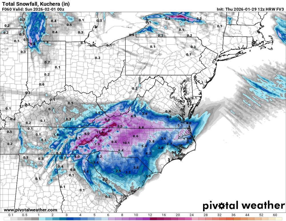
- 782 replies
-
- 1
-
-
- extreme cold
- snow
- (and 1 more)
-
1-30/2-1-26 Arctic Blast, ULL Snow Event
fountainguy97 replied to John1122's topic in Tennessee Valley
Amazing how you can see the flow stacking up against the mountains.- 782 replies
-
- 1
-
-
- extreme cold
- snow
- (and 1 more)
-
1-30/2-1-26 Arctic Blast, ULL Snow Event
fountainguy97 replied to John1122's topic in Tennessee Valley
You guys are right. The EURO is stair stepping west with 0/12 being not as extreme then 6/18 jumping west. But each stair is ultimately further west. Strange to see.- 782 replies
-
- 2
-
-
- extreme cold
- snow
- (and 1 more)
-
1-30/2-1-26 Arctic Blast, ULL Snow Event
fountainguy97 replied to John1122's topic in Tennessee Valley
Me too. I think the RGEM actually would be the scenario you are suggesting. ULL/home grown and then a quicker pulling to the coast.
-
1-30/2-1-26 Arctic Blast, ULL Snow Event
fountainguy97 replied to John1122's topic in Tennessee Valley
But how much of the precip is actually from the SLP along the coast? My understanding is the vast majority of what we are getting is associated with the 700mb low and the 5h energy. Not many coastal storms have occurred since I've been here. So I'm out of my league there. In general I do agree this is a fickle setup and one that I'm still skeptical of. -
1-30/2-1-26 Arctic Blast, ULL Snow Event
fountainguy97 replied to John1122's topic in Tennessee Valley
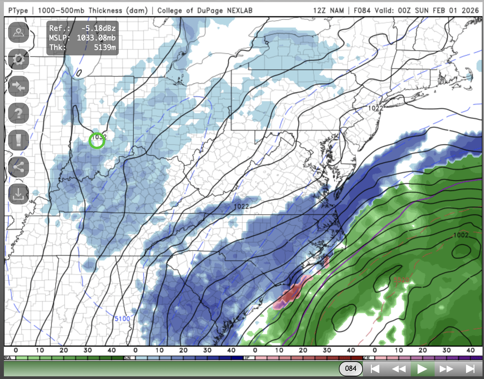
the NAM is a beauty. just gorgeous pivot over ETN- 782 replies
-
- 1
-
-
- extreme cold
- snow
- (and 1 more)
-
1-30/2-1-26 Arctic Blast, ULL Snow Event
fountainguy97 replied to John1122's topic in Tennessee Valley
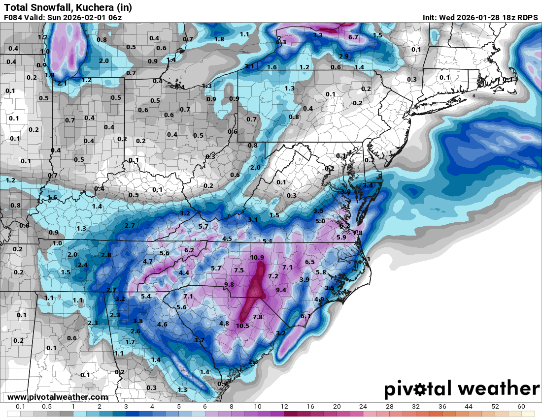
yeah that's Kuchera so it takes that into account. We start around 14-16:1 and by the end are toward 25:1.- 782 replies
-
- 2
-
-
- extreme cold
- snow
- (and 1 more)
-
1-30/2-1-26 Arctic Blast, ULL Snow Event
fountainguy97 replied to John1122's topic in Tennessee Valley
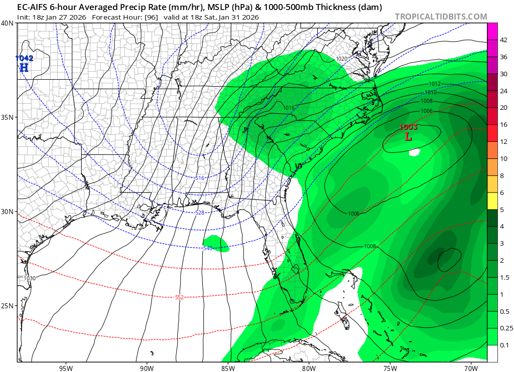
Euro joins the ULL mountain focus and a late blooming coastal solution. It and weathernext are locked in.
- 782 replies
-
- 1
-
-
- extreme cold
- snow
- (and 1 more)
-
1-30/2-1-26 Arctic Blast, ULL Snow Event
fountainguy97 replied to John1122's topic in Tennessee Valley
Man a great west trend for TN this 12z suite so far. CMC also further west- 782 replies
-
- 1
-
-
- extreme cold
- snow
- (and 1 more)
-
1-30/2-1-26 Arctic Blast, ULL Snow Event
fountainguy97 replied to John1122's topic in Tennessee Valley
You can't see it on most sites but COD Weather has amazing precipitation tables for NW stuff. Here on the 12z NAM is was about to push some heavy NW moisture into the region. It was going to be a similar outcome to RGEM although different driving factors.
- 782 replies
-
- 1
-
-
- extreme cold
- snow
- (and 1 more)
-
1-30/2-1-26 Arctic Blast, ULL Snow Event
fountainguy97 replied to John1122's topic in Tennessee Valley
Yep that's how you get that second moisture push from the coastal. Great outcome. -
1-30/2-1-26 Arctic Blast, ULL Snow Event
fountainguy97 replied to John1122's topic in Tennessee Valley
SREF doesn't follow the NAM so this is likely a feedback issue we see often on long range nam. But even it is a good ETN hit. RGEM is and has been very good at range in the past. Icon still not playing ball with the coastal but the ULL is a good hit for ETN -
1-30/2-1-26 Arctic Blast, ULL Snow Event
fountainguy97 replied to John1122's topic in Tennessee Valley
A safe bet right now is the ULL moisture at the start. That's barely 2.5 days out at this point. The bigger question is what interactions happen after that. Everything is still on the table for the eastern valley region. At the end of the day someone is going to be just too far west and will watch a county over get some snow. This does remind me a lot of the December 2010 storm. I believe it was also some ULL moisture to start and then the coastal backed another batch over the mountains. It was also a last second thing.- 782 replies
-
- 1
-
-
- extreme cold
- snow
- (and 1 more)
-
1-30/2-1-26 Arctic Blast, ULL Snow Event
fountainguy97 replied to John1122's topic in Tennessee Valley
Euro ticked west a bit. But mostly the same. AIFS very close to the same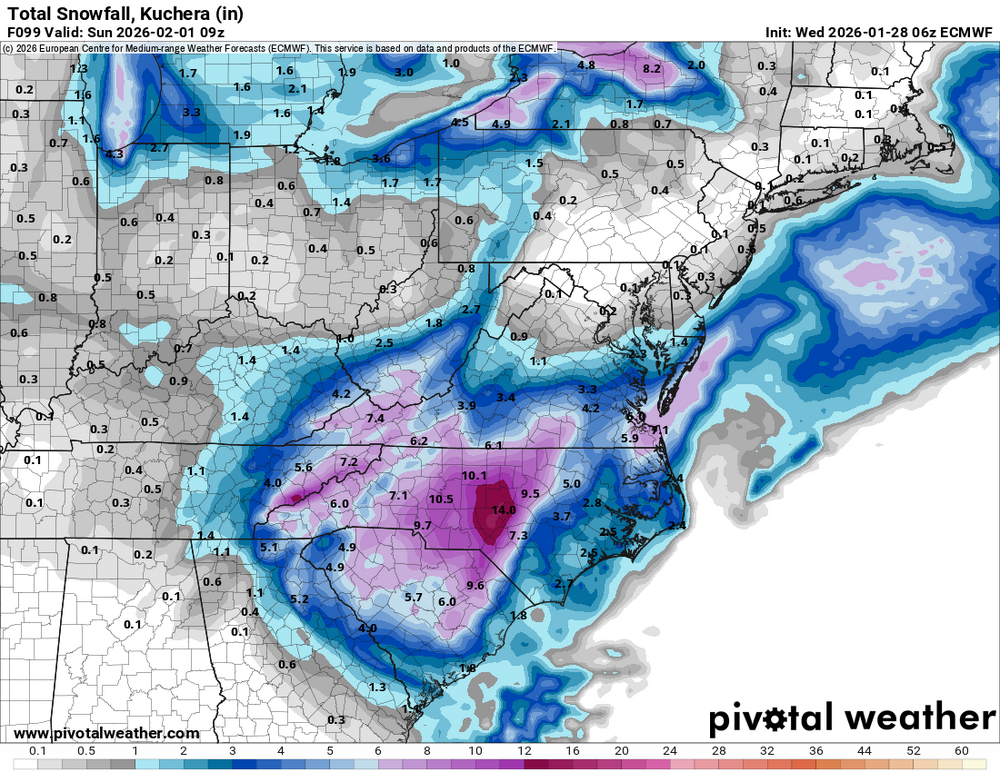
- 782 replies
-
- 1
-
-
- extreme cold
- snow
- (and 1 more)
-
1-30/2-1-26 Arctic Blast, ULL Snow Event
fountainguy97 replied to John1122's topic in Tennessee Valley
Here are the latest models. 7 of them. All of them in agreement about the ULL sliding moisture. Vary degrees of intensity. and then the GFS with the coastal lol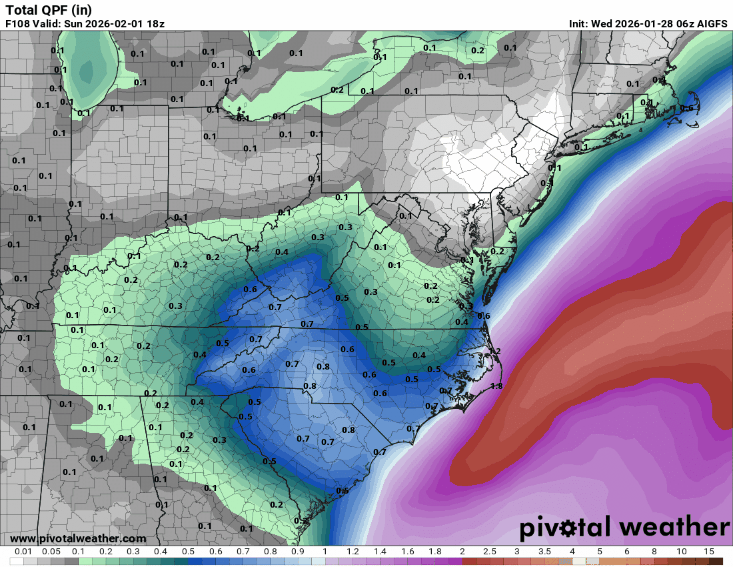
- 782 replies
-
- 1
-
-
- extreme cold
- snow
- (and 1 more)
-
1-30/2-1-26 Arctic Blast, ULL Snow Event
fountainguy97 replied to John1122's topic in Tennessee Valley
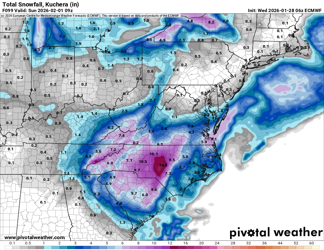
Models are in pretty good agreement with regards to the ULL energy diving a precip maxima from ETN down into SC/NC. The main question continues to be the coastal. ON euro/gfs/nam our starting ratios are 15:1 and peak at 24:1 toward the end of the event. It won't take much qpf at all. .5 qpf at 15:1 is 7.5"- 782 replies
-
- 3
-
-
- extreme cold
- snow
- (and 1 more)
-
January 2026 Short/Medium Range Thread
fountainguy97 replied to John1122's topic in Tennessee Valley
Yeah this trend is good for those east of our forum area. But a good trend for them also probably helps increase the energy we have to play around with. We pretty much want the same thing but it'll be different pieces driving the bus for us compared to the ENC crew. -
January 2026 Short/Medium Range Thread
fountainguy97 replied to John1122's topic in Tennessee Valley
So the question is do I hate on the gfs again before 00z for double or nothing? -
January 2026 Short/Medium Range Thread
fountainguy97 replied to John1122's topic in Tennessee Valley
So all we need to do is hate on the GFS a bit and now the euro is heading to the gfs lol. -
January 2026 Short/Medium Range Thread
fountainguy97 replied to John1122's topic in Tennessee Valley
Euro-ai. Significantly west
-
January 2026 Short/Medium Range Thread
fountainguy97 replied to John1122's topic in Tennessee Valley
If the GFS misses this storm again (it likely will) like last week it should be shut down. The power it uses would be better used elsewhere. How has the American flagship model gotten so obsolete? It's truly embarrassing. -
January 2026 Short/Medium Range Thread
fountainguy97 replied to John1122's topic in Tennessee Valley
Will be interesting to see what the High-res models do with the ULL moisture as they get into range. Even without the bomb Eastern areas may actually have a shot at the biggest snow of the year. -
January 2026 Short/Medium Range Thread
fountainguy97 replied to John1122's topic in Tennessee Valley
Heading east overnight. Not surprised. Weathernext leading the way. It has ticked east the last 4 runs. It's amazing how we are nearly in the same boat as last storm. GFS is still a hit but it's behind the euro and weather next which gives us false hope. The only difference is the cmc is still a hit as well. Still worth watching but just on the back burner as a side dish no one really intends to eat. just hit 6.0 this morning. Chilly. -
January 2026 Short/Medium Range Thread
fountainguy97 replied to John1122's topic in Tennessee Valley
Yeah this one may be an NC special! Cold and dry here this weekend most likely. Pattern looks cold. We will probably have more action at some point.