

GaWx
-
Posts
19,132 -
Joined
Content Type
Profiles
Blogs
Forums
American Weather
Media Demo
Store
Gallery
Everything posted by GaWx
-
I count 8 of 30 (27%) of 12Z GFS ensemble members landfalling on the Conus from TX to ME within 8/27-9. GEFS suggests the MJO will most likely then be in phase 5, a rather active phase for Conus though not as active as phases 2 and 8. This is keeping me with a moderate concern for now: But the 12Z Euro like the 0Z has no TC from this. Also, it isn’t on the 12Z CMC. So, we’ll see. I already noted the 12Z UKMET with it.
-
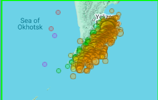
From Dr. Viterito via JB 8/14/25: I've been keeping a very close eye on this area, as it has been a geothermal hotspot helping to feed the Kuroshio Current, the Pacific's equivalent to the Gulf Stream. Did you notice at the very end of the video the narrator talks about the fact that geothermal heating enables the major port to be ice-free year round and that the area is used as a submarine base? "The "culprit" here is the submarine activity of the Eastern Volcanic Front off the east coast of Kamchatka." As the map shows, there has been a tremendous amount of underwater seismic activity in this area for the past 30 days. For the record, there have been 1036 seismic events, the vast majority of which are associated with underwater magma displacement. Keep in mind, these magmas can reach temperatures of 400 degrees C! IRIS/Wilber 3, Mx >=3, July 15 - August 14, 2025. The water off the east coast of Kamchatka moves southward vis the Kamchatka current. Here is a map of this: Wikidata The Kamchatka Current then feeds the Kuroshio Current, and in this case, is providing exceptional warmth to the Kuroshio. This is starkly illustrated in today's sea surface temperature map. In this map the source region is clearly the southeast coast of Kamchatka, and we can see that excess warmth being transported by the Kamchatka Current, which then merges with the Kuroshio. By contrast, here is the seismic map for March, 2025. For that month, there were only 17 seismic events: IRIS/Wilber 3, Mx >=3, March 6, 2025 - April 5, 2025. Here is the resultant SST map (April 6, 2026 [sic]): Clearly, the "hot spot" was much weaker when the seismic activity was lower. It can be argued that the Kamchatka source region is responsible for the large temperature anomaly the Kuroshio is currently experiencing. It's about time the climate community starts to recognize the importance of geothermal inputs into the system. ————————— Any comments?
-
Unlike the 0Z, the 12Z UKMET is back (similar to yesterday’s 12Z that I’m quoting) with a followup AEW to Erin becoming a TD at 162 and nearly to a TS at 168 just N of the Virgin Islands moving WNW. This looks like the same AEW that the 12Z GFS has but is ~500 miles further WNW than the GFS at 168, which is then only near 16N, 58W. This is the AEW causing the commotion in the SE US on the 6Z GEFS during 8/26-30: NEW TROPICAL CYCLONE FORECAST TO DEVELOP AFTER 162 HOURS FORECAST POSITION AT T+162 : 18.9N 62.8W LEAD CENTRAL MAXIMUM WIND VERIFYING TIME TIME POSITION PRESSURE (MB) SPEED (KNOTS) -------------- ---- -------- ------------- ------------- 1200UTC 22.08.2025 168 19.4N 64.7W 1005 33
-
You must be thinking of 2019’s Humberto. I’m referring to 2007’s, which hit upper TX/W LA.
-
-Just for the record fwiw, the 6Z GFS hits Daytona on Aug 29 (way out at 2 weeks) -Much more statistically significant than just a fantasyland op run, its ensemble is unsettlingly pretty active in/near the SE US during Aug 26-30. Here’s a snapshot as of hour 294 (12Z on 8/27): -During this active period, GEFS has the MJO in/near phase 5. It’s not either of the 2 most active phases for H hits per day during Jul-Sep since 1975 (phases 2 and 8), but phase 5 has had the 3rd highest ratio of hits/day. - During phase 5, these 10 Hs hit the Conus: Francine (2024), Ike (2008), Humberto (2007), Ophelia (2005), Isabel (2003), Bertha (1996), Fran (1996), Bob (1991), Elena (1985), and Babe (1977). Two areas were most impacted by these 10: NC (Ophelia, Isabel, Bertha, Fran, and Bob) and upper TX to FL panhandle (Francine, Ike, Humberto, Elena, and Babe).
-
I’ve already had the equivalent of a very wet TC with 12” of rain so far this month even without a TC! The last thing this area needs is more heavy rain as well as trees being easily toppled due to a high water table. After strong effects in ‘24 from the combo of Debby (10.9” of rain) and Helene (115 hour power outage/loss of food that took only high end TS winds/gusts to ~75 mph), I’d especially love a break. (By the way, FEMA never paid me for the food losses it promised even though I applied on the phone. ) Of course what I got pales in comparison to what others got from Helene to my W and NW and from Milton in FL. They’re the ones that especially need a break! Among other problems, the homeowner’s insurance situation is already ugly in much of the SE. I obviously like to follow and discuss these monsters and enjoy the challenge of forecasting what they’ll do. They’re also pretty to look at on satellite pics and are absolutely fascinating, but I want no part of them! Because of that, a boring quiet rest of the season wouldn’t bother me. However, I won’t let that desire bias my posts away from objectivity. Back to the present: 0Z UKMET has no followup TC to Erin unlike the prior runs.
-
Followup: this looks like an AEW preceding the one the last two UKMET runs had with a TD forming 200 miles E of Guadalupe 12Z UKMET NEW TROPICAL CYCLONE FORECAST TO DEVELOP AFTER 168 HOURS FORECAST POSITION AT T+168 : 16.4N 58.4W LEAD CENTRAL MAXIMUM WIND VERIFYING TIME TIME POSITION PRESSURE (MB) SPEED (KNOTS) -------------- ---- -------- ------------- ------------- 1200UTC 21.08.2025 168 16.4N 58.4W 1009 32
-
The last two UKMET runs also have this followup to Erin.
-
Followup to above: 0Z UKMET has a similarly placed TD following Erin vs the 12Z run: NEW TROPICAL CYCLONE FORECAST TO DEVELOP AFTER 156 HOURS FORECAST POSITION AT T+156 : 15.9N 28.1W LEAD CENTRAL MAXIMUM WIND VERIFYING TIME TIME POSITION PRESSURE (MB) SPEED (KNOTS) -------------- ---- -------- ------------- ------------- 1200UTC 20.08.2025 156 15.9N 28.1W 1010 33 0000UTC 21.08.2025 168 15.8N 30.4W 1009 29
-
At Least 3 Killed in Tennessee Flooding as More Rain Is Forecast Rescue crews pulled people out of submerged cars and homes overnight as floods swept the southeastern part of the state. A family of three was killed outside Chattanooga and emergency crews conducted water rescues as floods swept through Tennessee overnight. More flooding was expected in the eastern part of the state on Wednesday. After midnight, a large tree fell and crushed the car of a family in East Ridge, a suburb of Chattanooga, said Amy Maxwell, a spokeswoman for the Hamilton County Office of Emergency Management. “They died on the scene,” she said. “It’s obviously due to the loose soil that caused the tree to fall.” https://www.nytimes.com/2025/08/12/us/flooding-chattanooga-tennessee.html
-
12Z UK: for several runs has had this after Erin: NEW TROPICAL CYCLONE FORECAST TO DEVELOP AFTER 156 HOURS FORECAST POSITION AT T+156 : 15.9N 24.3W LEAD CENTRAL MAXIMUM WIND VERIFYING TIME TIME POSITION PRESSURE (MB) SPEED (KNOTS) -------------- ---- -------- ------------- ------------- 0000UTC 20.08.2025 156 15.9N 24.3W 1010 28 1200UTC 20.08.2025 168 15.7N 28.1W 1009 32
-
~25 total ACE for those 3 progged storms, combined
-
I’m glad you asked because despite the 80% of 2005-24 avg ACE, it’s predicting ~3 NS for Sep 1-14. That’s actually slightly above the 2005-24 avg of 2.5 NS. That implies shorter tracks/possible W basin.
-
The latest Euro Weeklies are showing only 80% of ACE for 9/1-14, a big drop from the progged 400% for 8/18-24 due to Erin to ~1/2 the ACE for each of those weeks vs its 8/18-24 prog (likely MJO related). But then again, it’s 80% of the very active 2005-24 climo for near peak season. So, even if the 80% were to verify well, that would still mean an active period (even though not to the degree of the Erin week) and would end up way more active than for that period in 2024. Sep 1-14 of 2024 had only ~5-6 ACE, which is a mere <20% of the ~31 ACE avg for Sep 1-14 of 2005-24. Compare that to the EW’s 80% prog, which would be ~25 ACE for Sep 1-14 of 2025 or 4-5 times as high as 2024.
-
That means the equivalent daily NOAA PDO has risen from ~-4.25 to near -3.
-
I estimate I’ve gotten 33.85” during the last 90 days! May 14-31: 6.7” June 6.85” July 8.25” Aug 1-11: 12.05”! Last year I got 13.3” Aug 1-11, but that included a 3 day total of 10.9” from Debby. I never thought I’d be this close to 8/1-11/24 without a TC! My normal for May 14-Aug 11 is ~19.25” meaning I’ve gotten ~175% of normal! My backyard is like a very wet sponge wherever there’s no standing water. The mosquitos have been in heaven.
-
Here we go again. Another batch with some heavy rain has just arrived from the south. Before this as of last night’s rains I had just made it to 12” MTD with none due to a tropical cyclone as we know. Edit: Good news was that this batch was short-lived and gave me only <0.1”.
-
Then this was in the forecast discussion this morning: AREA FORECAST DISCUSSION NATIONAL WEATHER SERVICE CHARLESTON SC 612 AM EDT MON AUG 11 2025 SYNOPSIS A STATIONARY FRONT TO THE SOUTH OF THE REGION SHOULD DISSIPATE TODAY. BY MID TO LATE WEEK, SURFACE HIGH PRESSURE WILL SHIFT INTO THE ATLANTIC, WHILE WEAK TROUGHING FORMS INLAND. NEAR TERM /THROUGH TONIGHT/ THE UPPER-LEVEL ANTICYCLONE THAT HAS BEEN POSITIONED WELL OFFSHORE OF THE SOUTHEAST U.S. FOR THE PAST SEVERAL DAYS WILL BEGIN TO BUILD WEST TODAY AND REPLACE THE MID-LEVEL WEAKNESS THAT HAS BEEN IN PLACE SINCE LAST FRIDAY. THE ATMOSPHERE WILL REMAIN MODESTLY UNSTABLE THROUGH THE AFTERNOON WITH A PLUME RICH, TROPICAL MOISTURE FEATURING PWATS HOLDING IN THE 2.30-2.65". SIMILAR TO THE PAST FEW DAYS, PASSING BITS OF VORTICITY PROPAGATING ALONG THE WESTERN PERIPHERY OF THE UPPER HIGH WILL BRING SEVERAL MORE BANDS/WAVES TO SHOWERS/TSTMS TO THE AREA. and THE HIGHEST RAIN TOTALS SINCE FRIDAY HAVE BEEN MOSTLY CONFINED TO THE COASTAL COUNTIES WHICH SHOULD CONTINUE AGAIN TODAY. ***SOME AREAS HAVE SEEN AS MUCH AS FOOT OF RAIN OVER THE PAST SEVERAL DAYS ALONE WHICH IS DOWNRIGHT INCREDIBLE FOR AUGUST OUTSIDE OF A TROPICAL CYCLONE.*** ————— I had been up to ~9.9” month to date through the period just before the rains returned at 11:30 PM last night. I don’t yet have my overnight total, but it was significant once again, quite possibly ~2”. I’ll update later. Edit: I had 2.1” from 11:30PM through the rest of the night (8/11 AM) bringing me to 12” MTD!
-
Followup: It turned out that several bands of rain, sometimes moderate or heavy, continued to come in from the SE over this area. There was heavy near and soon after midnight. And then while I was sleeping, this occurred, still another FF warning for still another band of heavy:BULLETIN - EAS ACTIVATION REQUESTED FLASH FLOOD WARNING NATIONAL WEATHER SERVICE CHARLESTON SC 156 AM EDT MON AUG 11 2025 THE NATIONAL WEATHER SERVICE IN CHARLESTON HAS ISSUED A * FLASH FLOOD WARNING FOR... CHATHAM COUNTY IN SOUTHEASTERN GEORGIA... JASPER COUNTY IN SOUTHEASTERN SOUTH CAROLINA... * UNTIL 400 AM EDT. * AT 156 AM EDT, DOPPLER RADAR INDICATED AN LARGE BAND OF SHOWERS AND THUNDERSTORM WITH TORRENTIAL RAINFALL JUST OFF THE COAST OF CHATHAM COUNTY. THIS BAND WILL MOVE ACROSS MUCH CHATHAM COUNTY INTO PARTS OF JASPER COUNTY THROUGH 4 AM. THIS INCLUDES MUCH OF THE SAVANNAH METRO AREA. AS MUCH AS 1 TO 3 INCHES OF RAIN COULD FALL OVER A VERY SHORT PERIOD. THIS WILL RESULT IN URBAN FLOODING AND FLASH FLOODING. ROAD CLOSURES ARE POSSIBLE, ESPECIALLY ACROSS DOWNTOWN SAVANNAH. HAZARD...FLASH FLOODING CAUSED BY THUNDERSTORMS. SOURCE...RADAR INDICATED. IMPACT...FLASH FLOODING OF SMALL CREEKS AND STREAMS, URBAN AREAS, HIGHWAYS, STREETS AND UNDERPASSES AS WELL AS OTHER POOR DRAINAGE AND LOW-LYING AREAS. * SOME LOCATIONS THAT WILL EXPERIENCE FLASH FLOODING INCLUDE... POOLER, BLUFFTON, TYBEE ISLAND, MIDTOWN SAVANNAH, DOWNTOWN SAVANNAH, HUTCHINSON ISLAND, HUNTER ARMY AIRFIELD, WINDSOR FOREST, WILMINGTON ISLAND AND COFFEE BLUFF.————————Then this statement was issued:CHATHAM GA-JASPER SC- 326 AM EDT MON AUG 11 2025 ...FLASH FLOOD WARNING REMAINS IN EFFECT UNTIL 4 AM EDT EARLY THIS MORNING FOR CHATHAM AND JASPER COUNTIES... AT 326 AM EDT, DOPPLER RADAR INDICATED MODERATE TO LOCALLY HEAVY RAIN FALLING OVER MUCH OF CHATHAM COUNTY. WHILE THE MOST INTENSE RAIN HAS SHIFTED NORTH OF THE AREA, THE RISK FOR FLOODING CONTINUES. AS MUCH AS 1 TO 2.5 INCHES OF RAIN HAS FALLEN IN SOME AREAS SINCE 2 AM. HAZARD...FLASH FLOODING CAUSED BY THUNDERSTORMS. SOURCE...RADAR INDICATED. IMPACT...FLASH FLOODING OF SMALL CREEKS AND STREAMS, URBAN AREAS, HIGHWAYS, STREETS AND UNDERPASSES AS WELL AS OTHER POOR DRAINAGE AND LOW-LYING AREAS. SOME LOCATIONS THAT WILL EXPERIENCE FLASH FLOODING INCLUDE... POOLER, BLUFFTON, TYBEE ISLAND, MIDTOWN SAVANNAH, DOWNTOWN SAVANNAH, HUTCHINSON ISLAND, HUNTER ARMY AIRFIELD, WINDSOR FOREST, WILMINGTON ISLAND AND COFFEE BLUFF.
-
0Z UKMET for what may be first AEW behind 97L: NEW TROPICAL CYCLONE FORECAST TO DEVELOP AFTER 150 HOURS FORECAST POSITION AT T+150 : 16.0N 49.7W LEAD CENTRAL MAXIMUM WIND VERIFYING TIME TIME POSITION PRESSURE (MB) SPEED (KNOTS) -------------- ---- -------- ------------- ------------- 1200UTC 17.08.2025 156 17.0N 51.1W 1010 27 0000UTC 18.08.2025 168 18.4N 53.9W 1011 24
-
After having no rain throughout the daytime of 8/10, which allowed me to go to Tybee with some friends, rain showers (some heavy) coming off the ocean moving NW started at 11:30PM. It looks like per radar that periods of rain may last til after midnight. Edit: Before this, I was already way up at ~9.9” of rain for August!
-
Just what we don’t need, still another batch of moderate to heavy rain moving in at 1PM. Edit: This and other rain on 8/9 plus other rains after midnight on 8/10 during the late night added to ~0.9”. That put me up to 9.9” MTD!
-
After this, I got several more rounds of rain through the evening of 7/8 adding to that gotten yesterday afternoon adding up to a total of ~1.3”. After emptying that, I then through the early morning hours (7/9) received heavy showers coming off the ocean with the heaviest 5-5:30AM. I estimate 2” from the late night through now (7:40AM) with light rain still falling. All of this is on top of the 6” I got Aug 1-6! So, I’m at ~9.3” Aug 1 through 7:40AM of Aug 9!My water table is ridiculously high. Fortunately though due to the rains being spread out enough, I’ve yet to have any garage flooding this month despite heavy puddling of rain sitting just outside the garage. However, more heavy rains are possible over the next few days.Not one but two flash flood warnings were up for the county since late afternoon yesterday (8/8)!#1:BULLETIN - EAS ACTIVATION REQUESTED FLASH FLOOD WARNING NATIONAL WEATHER SERVICE CHARLESTON SC 353 PM EDT FRI AUG 8 2025 THE NATIONAL WEATHER SERVICE IN CHARLESTON HAS ISSUED A * FLASH FLOOD WARNING FOR... CHATHAM COUNTY IN SOUTHEASTERN GEORGIA... * UNTIL 700 PM EDT. * AT 353 PM EDT, DOPPLER RADAR INDICATED THUNDERSTORMS PRODUCING HEAVY RAIN ACROSS THE WARNED AREA. BETWEEN 1.5 AND 2.5 INCHES OF RAIN HAVE FALLEN. ADDITIONAL RAINFALL AMOUNTS OF 1 TO 2 INCHES ARE POSSIBLE IN THE WARNED AREA. FLASH FLOODING IS ONGOING OR EXPECTED TO BEGIN SHORTLY. HAZARD...FLASH FLOODING CAUSED BY THUNDERSTORMS. SOURCE...RADAR INDICATED. IMPACT...FLASH FLOODING OF SMALL CREEKS AND STREAMS, URBAN AREAS, HIGHWAYS, STREETS AND UNDERPASSES AS WELL AS OTHER POOR DRAINAGE AND LOW-LYING AREAS. * SOME LOCATIONS THAT WILL EXPERIENCE FLASH FLOODING INCLUDE... POOLER, DOWNTOWN SAVANNAH, HUTCHINSON ISLAND, HUNTER ARMY AIRFIELD, MIDTOWN SAVANNAH, WINDSOR FOREST, SAVANNAH INTERNATIONAL AIRPORT, GARDEN CITY, PORT WENTWORTH AND THUNDERBOLT. CITY OF SAVANNAH EMERGENCY MANAGEMENT REPORTS THAT NUMEROUS ROADS IN THE SAVANNAH AREA ARE BEGINNING TO FLOOD. ADDITIONAL RAINFALL OVER THE NEXT HOUR WILL CONTINUE TO WORSEN ONGOING FLOODING.—————————-#2:BULLETIN - EAS ACTIVATION REQUESTED FLASH FLOOD WARNING NATIONAL WEATHER SERVICE CHARLESTON SC 520 AM EDT SAT AUG 9 2025 THE NATIONAL WEATHER SERVICE IN CHARLESTON HAS ISSUED A * FLASH FLOOD WARNING FOR... CHATHAM COUNTY IN SOUTHEASTERN GEORGIA... * UNTIL 715 AM EDT. * AT 520 AM EDT, DOPPLER RADAR INDICATED A BAND HEAVY RAIN EXTENDING FROM DOWNTOWN SAVANNAH TO THE SAVANNAH RIVER ENTRANCE AND EXTENDING OFFSHORE. THIS BAND WILL CONTINUE TO PUSH WEST ACROSS PORTIONS OF THE SAVANNAH METRO AREA. UP TO A INCH OF RAIN HAS ALREADY FALLEN IN SOME AREAS THIS MORNING. AN ADDITIONAL 1 TO 2 INCHES OF RAIN COULD FALL THROUGH 7 AM, RESULTING IN AREAS OF URBAN FLOODING AND FLASH FLOODING. FLOODED ROADWAYS ARE LIKELY WHICH MAY RESULT IN CLOSURES. HAZARD...FLASH FLOODING CAUSED BY HEAVY RAIN. SOURCE...RADAR INDICATED. IMPACT...FLASH FLOODING OF SMALL CREEKS AND STREAMS, URBAN AREAS, HIGHWAYS, STREETS AND UNDERPASSES AS WELL AS OTHER POOR DRAINAGE AND LOW-LYING AREAS. * SOME LOCATIONS THAT WILL EXPERIENCE FLASH FLOODING INCLUDE... POOLER, TYBEE ISLAND, MIDTOWN SAVANNAH, DOWNTOWN SAVANNAH, HUTCHINSON ISLAND, HUNTER ARMY AIRFIELD, WILMINGTON ISLAND, WINDSOR FOREST, FORT PULASKI NATIONAL MONUMENT AND GARDEN CITY.
-
My analysis had nothing to do with date of formation. It was strictly based on date of Conus landfalls.
-
MJO phase (whether inside or outside the circle) 1975-2024 Jul-Sep on day of 67 CONUS hurricane hits 1: 7 (10%) 2: 17 (25%) 3: 7 (10%) 4: 7 (10%) 5: 10 (15%) 6: 6 (9%) 7: 2 (3%) 8: 11 (16%) ——————— MJO phase (whether inside or outside the circle) 1975-2024 Jul-Sep on day of 23 CONUS MAJOR hurricane hits 1: 3 (13%) 2: 9 (39%) 3: 2 (9%) 4: 2 (9%) 5: 2 (9%) 6: 2 (9%) 7: 0 (0%) 8: 3 (13%) Analysis: When considering just MH hits, phase 2 has easily had the most hits of any one phase. You may wonder (and I wondered at first, myself) if that’s because there were far more days in phase 2 than any other phase during Jul-Sep 1975-2924. Answer: 16.8% or 1 in 6. So, it had somewhat more than an avg share, which is 12.5%. But that’s not nearly enough to fully explain the high phase 2 #s for MH. **Edited Conclusion: So, phase 2 really has had by a good margin the highest frequency of MH CONUS hits per days in that phase during Jul-Sep since 1975. Regarding all H when considering that phase 8 had only 10.1% of the days, phases 8 and 2 are neck and neck for the highest hit freq. per day. Phase 5 has the 3rd highest. Sources: I looked at the following sources and did the calculations: 1. MJO phase: http://www.bom.gov.au/clim_data/IDCKGEM000/rmm.74toRealtime.txt 2. H classification/hit dates: NHC archives 3. For Katrina and Ian, I counted only the day of the more intense hit to determine MJO phase. For Andrew, both hits were during phase 6.


