

GaWx
-
Posts
19,132 -
Joined
Content Type
Profiles
Blogs
Forums
American Weather
Media Demo
Store
Gallery
Everything posted by GaWx
-
Hey Liberty, If the average relative humidity were to have risen, then I’d agree. Whereas the avg dewpoint has risen (reflecting increased moisture content), there’s no indication the RH has also risen as the temps have risen along with the dewpoints.
-
I compared the 0Z 7/22 GFS and Euro progged highs for ATL. Now I’ll do it for NC: 0Z 7/22 hottest highs for RDU/GSO/FAY: 0Z 7/22 GFS: RDU 102 (7/29), GSO 101 (7/29), FAY 104 (7/28) 0Z 7/22 Euro: RDU 98 (7/27); GSO 98 (7/27, 7/30, 7/31); FAY 100 (7/27) So, the 0Z 7/22 GFS’ hottest is hotter than that for the Euro by 3-4 F. That sounds quite familiar. Who do you favor? Based on many significantly too hot GFS runs and much closer Euro runs for the late June heatwave, I’m easily favoring the Euro for GSO/FAY. RDU is tricky though because of its often too hot sensor. So, I’ll go halfway between for RDU (what verified there in late June). So, I’m going 100 for RDU, 98 for GSO, and 100 for FAY as of now for a wild guess of the hottest of 7/27-31.
-
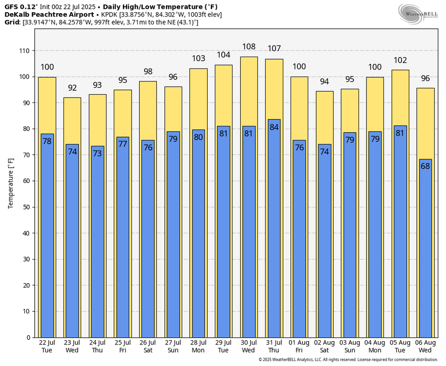
Based on the quotes I copied below from June showing the GFS as having verified as being much too hot for highs, the 0Z 7/22 GFS will almost certainly verify as too hot and likely much too hot for highs as the hottest at ATL was 95 on 6/24 and 96 on 6/25. First, here’s the laughable 0Z 7/22 GFS for KPDK (NE ATL/Chamblee) (0Z Euro is much cooler there with hottest highs of “only” 101 on 7/30 and 103 on 7/31 and will likely come much closer): highs of 100 today vs FFC’s forecast of 96, 103 on 7/28, 104 on 7/29, 108 on 7/30, and 107 on 7/31 (Keeping in mind that FFC was almost spot on for the late June heat by being much cooler than the GFS, FFC’s forecast hottest through 7/29 is only mid 90s): Second, here are quotes of two posts I made elsewhere in late June showing the way too hot GFS progs for late June highs: “KATL is also looking brutal on the 6Zs this week with these highs: (GFS/Euro) 6/22: 96/91 6/23: 99/95 6/24: 103/102 6/25: 101/104 6/26: 94/96 6/27: 96/87 Currently FFC has ATL’s hottest on 6/25 with upper 90s, but they’re watching closely.” and ”Which did better today for highs, GFS or Euro? 6Z GFS/Euro highs today for: RDU: 103/99 vs actual of 100; Euro wins GSO: 101/100 vs actual of 95; both were terrible though Euro less terrible FAY: 99/99 vs actual of 98; both did well ATL: 102/98 vs actual of 95; Euro did better than the awful GFS but still was 3 too hot Euro also did better yesterday at GSO and FAY So for these 2 days overall, Euro did significantly better than GFS, which tended to be at least several degrees too hot.”
-
Actually, Graham had heavy rains from not one but two TCs in Sept of 1999: -6.36” Sept 5-7 from Dennis -4.30” Sept 15-17 from Floyd In addition, they had 5.12” Sept 27-30 from I don’t know what (no named storm then). https://www.weather.gov/wrh/Climate?wfo=rah
-
Invest 94L is no more. The following isn’t out of the norm for a late July TWO: Tropical Weather Outlook NWS National Hurricane Center Miami FL 800 AM EDT Tue Jul 22 2025 For the North Atlantic...Caribbean Sea and the Gulf of America: Tropical cyclone formation is not expected during the next 7 days. $$ Forecaster Pasch
-
An outflow boundary just came through here. No rain here yet. Hearing thunder. Very dark skies just to the south. Edit 7:45PM: Here there was a collision of that aforementioned outflow boundary, which actually appeared to be a seabreeze on closer examination, and one moving in nearly the opposite direction (from inland) that was true outflow from a well inland thunderstorm complex. That collision lead to an area of thunderstorms near the coast and which soon after made it here. There had just been a short period of heavy rain (first since July 13th) though it has for now lightened up. Looking at radar, the thunderstorm area may hang around for awhile. Crossing my fingers this doesn’t turn into a heavy rainfall event. Now moderately heavy rain. There’s been some rather hefty gusts with this, too. High these last two days has been a very uncomfortable 97, hottest so far this year. Edit: Yesterday’s (7/21) rainfall was ~0.7”.
-
Good find. I see what you’re saying about the two of them mentioning Humberto by far the most frequently since last year. Though not absolute proof, it admittedly at least looks quite suspicious. Also, Barry vs Barrett fwiw. As you can see both accounts still show up with profiles. So, I assume that means different IP addresses. Probably not but does that tell you anything?
-
Thanks, Yoda. So, this Andy Hazelton tweet is sort of agreeing with what Eric Webb just had said about an expected quiet August into early Sept. Note, however, that Andy said “I’m kinda of the same opinion that August may be quiet in the Atlantic”, which isn’t a forecast since August “may be quiet” in any year. A forecast would say something much more explicit like “August will be quiet”, “I expect August to be quiet”, or “August will likely be quiet”.
-
A nice dry outflow boundary ahead of a small area of convection has just come ESE through here with winds picking up. We’ll see if I get much rain. Edit: There was no rain here as it slid by just to my south.
-
The main diff, especially in the SE US, was that Feb of 2011 had a strongly +AO/NAO. Of DJF, F is often the warmest in La Nina. Edit: Also, in New England and NYC at least, DJF 2010-1 was actually colder than DJF 2009-10.
-
For those who may not realize this: The # of FFWs going up by a factor of ~5 over the last 40 years isn’t by any means just due to CC: Here’s why record-high flash flood warnings were issued in U.S. this year Rachel Dobkin Thu, July 17, 2025 There has been a record-high number of flash flood warnings issued in the U.S. this year, which can be linked to climate change and improved weather systems. Climate change can make river floods larger or more frequent in some places, according to the Environmental Protection Agency. But one expert explained another reason why there are more flash flood alerts than ever before. Amir AghaKouchak, director of the Center for Hydrometeorology and Remote Sensing at the University of California, Irvine, told NBC News radar systems and weather models have significantly improved over the last 40 years. “The system that was implemented back in the ‘80s is not the same as the system that we have now,” he said. “We have many, many more radars, and we have many different sources of data.” “So naturally you expect more warnings just because our systems are getting better and better,” the expert added. https://www.yahoo.com/news/why-record-high-flash-flood-000109408.html
-
But there’s no good reason imho to not be that way online as long as most others are that way in their interactions. People look at this in different ways. Some say that the real person may show up better online because of less inhibition to be oneself. OTOH, there are many trolls online.
-
Hey Barry, He’s in my list of posters with a bearish bias. If you took an avg of bull cat5 and bear 57, do you think they’d average neutral? Interesting fact: When baby boomer 57 joined there, Gen. Zer cat5 was near birth! Cat5 was born near the time that board was born. As you can see I called out bias in these two cases despite big age diffs.
-
Hey Barry, 57, a Houston area regular, is generous with his postings and is very knowledgable along with decades of experience with tropical forecasting. He runs his own tropical forecasting service. He’s one of the original regulars. So, for good reason, he’s very well respected and I’m glad he posts as much as he does. However, I do feel he tends to have a bit of a bearish lean in some of his public posts there. Again, imho as it’s subjective. And it’s by no means for nearly all posts. In addition, many times his bearish posts verify very well. I think that his desire to have quiet weekends sometimes influences his posts there toward the bear. Keep in mind that I prefer BB posters exhibit neither an explicit bearish nor an explicit bullish bias. I try my best to be perceived that way.
-
AAM: still has Ninoish peak next week Prior run (6 days ago):
-
Back to 1894-5, I have DJ of 1917-8 and 1976-7 as the coldest DJ in the E 1/2 of the US:
-
The E ATL avg anom has warmed as of 7/17 significantly: But OHC there as of 7/15 is still near the avg though climo warmer:
-
But 1916-7 was one of the most -PDO DJFs on record and 1917-8 averaged neutral.
-
From WB’s Joe D’Aleo today: That warm water east of Japan will move east in the North Pacific current north of the North Pacific Gyre. How much warmth will be carried east before the winter is something we will need to monitor. If it ends up staying more in mid-ocean, a very different winter story would evolve. This is just a heads up. When warm water in the Pacific has settled in the northeast Pacific, winters are brutal. Examples include 1976/77, 1977/78, 1993/94 and 1916/17, 1917/18 and 2013/14, 2014/15/ Those back to back cold winters turned the trend negative for 1996 to 2015. The winter snows also set records.
-
Today posted by Joe D’Aleo: Dr Viterito reported a new geothermal "hot spot" has emerged over the past 2 weeks, and it appears to be heating up the Kuroshio Current in the Pacific. Specifically, the Wilber 3 System has catalogued 76 seismic events since 6/21 off of the southern coast of Japan. The area impacted is a hydrothermal vent field to the west of the Ryukyu Islands, in an oceanic region known as the Okinawa Trough. See how the surface water has warmed in recent months: I was wondering if the recent very steep PDO drop started on 6/21/25. However, that actually started 6/8/25 rather than 6/21/25. By 6/21/25, the WCS daily PDO had already plunged to -2 from -1 as of 6/7/25:
-
At my location, the last 10 days have had an enormous contrast between the first 5 days and the last 5: 7/9-13: 6.35” total/rain every day with lots of street flooding and some flooding on my property/lots of standing water 7/14-18: only light amounts a couple of days totaling ~0.10”
-
Interesting dichotomy between the warm neutral subsurface and the cold neutral surface:
-
Agreed. But if it turns back down by the end of this month, the record NOAA PDO low of October 2024’s -3.80 would be in danger. For MTD, it’s likely in that vicinity now. That table goes way back to 1854.
-
Indeed, it’s not surprisingly bounced 0.50 from the extreme low of -3.45 of 7/8/25. This -2.95 WCS PDO translates to ~-3.75 NOAA PDO. NOAA’s dip on 7/8/25 was likely sub -4!
-
For the first time in weeks, the latest Euro Weeklies actually has a week forecasted to be slightly above the 2005-2024 average in the ATL basin. It’s for Aug 11-17. It has that week at 110% of 2005-24 avg: Just two runs ago it had that week at only 60% of 2005-24 avg: The highlighted areas have the highest chance (5%+) for a TC to be within 300 km:


