GaWx
-
Posts
19,031 -
Joined
Content Type
Profiles
Blogs
Forums
American Weather
Media Demo
Store
Gallery
Everything posted by GaWx
-
It appears per radar that Augusta might be about to get hit hard with something! Meanwhile: 2” reported at Byron, GA! (Just WNW of Warner Robbins)0830 AM SNOW 2 N POWERVILLE 32.63N 83.79W 01/18/2026 E2.0 INCH PEACH GA PUBLIC AN ESTIMATED 2 INCHES OF SNOW FELL AT HAYES CT IN BYRON. ————— *Edit: Wow, what a correction downward at Byron, GA, from 2” to 0.5”:1013 AM SNOW 2 N POWERVILLE 32.63N 83.79W 01/18/2026 E0.5 INCH PEACH GA PUBLIC CORRECTS PREVIOUS SNOW REPORT FROM 2 N POWERVILLE. AN ESTIMATED 0.5 INCH OF SNOW FELL AT HAYES CT IN BYRON.
-
0822 AM SNOW DE FUNIAK SPRINGS 30.72N 86.12W 01/18/2026 M0.5 INCH WALTON FL TRAINED SPOTTERPICTURE VIA SOCIAL MEDIA OF MEASUREMENT.
-
1.5” in Thomaston, GA! 0828 AM SNOW THOMASTON 32.89N 84.33W 01/18/2026 M1.5 INCH UPSON GA BROADCAST MEDIA REPORT OF 1.5 INCH OF SNOW IN THOMASTON.
-
0815 AM SNOW 3 WNW FLAT ROCK 32.56N 84.91W 01/18/2026 M1.5 INCH MUSCOGEE GA PUBLIC PUBLIC REPORT ON SOCIAL MEDIA OF 1.5 INCHES OF ACCUMULATION ON THE NORTHEAST SIDE OF COLUMBUS NEAR THE MAPLE RIDGE AREA.
-
Snow has started in Milledgeville, GA: 8AM: MILLEDGEVILLE* LGT SNOW 36 34 93 NW7G15 30.10R FOG WCI 30
-
@El Kabongin Perry is getting moderate snow now and it may get even heavier shortly. Americus has been getting accumulating snow for awhile. Radar suggests corridor centered from Cordele (shortly) northeast to Dublin (within an hour?) will probably be getting hit hard!
-
Radar indicates a heavy area of precip is aimed for just S of Macon (Warner Robbins southward) and then just E of Macon (Jeffersonville east)! Macon will be near NW border of this heavy precip. it appears.
-
PRELIMINARY LOCAL STORM REPORT NATIONAL WEATHER SERVICE PEACHTREE CITY GA 726 AM EST SUN JAN 18 2026 .TIME... ...EVENT... ...CITY LOCATION... ...LAT.LON .DATE... ....MAG.... ..COUNTY LOCATION..ST.. ...SOURCE. ..REMARKS.. 0720 AM SNOW 1 NW MIDLAND 32.58N 84.83W 01/18/2026 M1.0 INCH MUSCOGEE GA PUBLIC PUBLIC REPORT OF 1 INCH OF SNOWFALL IN MIDLAND GEORGIA. SNOW IS ACTIVELY ACCUMULATING.
-
It’s been snowing at Forsyth, GA nearly 30 min. Patience is recommended in Macon area as it’s about to start there:Here are 7AM hourly readings:COLUMBUS LGT SNOW 31 29 92 NW9 30.16R VSB 3/4 WCI 23 6HR MIN TEMP: 31; 6HR MAX TEMP: 44; 6HR PCP: 0.04; MACON LGT RAIN 37 35 92 NW10 30.10R WCI 30 TC 3 6HR MIN TEMP: 37; 6HR MAX TEMP: 45; 6HR PCP: 0.13; ROBINS AFB RAIN 39 36 87 NW16 30.09R WCI 30 TC 4 CITY SKY/WX TMP DP RH WIND PRES REMARKS LAGRANGE* CLOUDY 34 14 44 NW9 30.14R WCI 26 TC 1 SYLVANIA* RAIN 42 42 100 N6 30.04R TC 6 MILLEDGEVILLE* LGT RAIN 39 37 93 NW14G20 30.08R FOG WCI 31
-
This is hot off the press new:URGENT - WINTER WEATHER MESSAGE NATIONAL WEATHER SERVICE PEACHTREE CITY GA 713 AM EST SUN JAN 18 2026 GAZ089-090-181800- /O.UPG.KFFC.WW.Y.0001.000000T0000Z-260118T1800Z/ /O.EXA.KFFC.WS.W.0001.000000T0000Z-260118T1800Z/ MUSCOGEE-CHATTAHOOCHEE- INCLUDING THE CITIES OF COLUMBUS AND FORT BENNING 713 AM EST SUN JAN 18 2026 ..WINTER STORM WARNING IN EFFECT UNTIL 1 PM EST THIS AFTERNOON * WHAT...HEAVY SNOW. ADDITIONAL SNOW ACCUMULATIONS UP TO 1 TO 2 INCHES * WHERE...CHATTAHOOCHEE AND MUSCOGEE COUNTIES. * WHEN...UNTIL 1 PM EST THIS AFTERNOON. * IMPACTS...PLAN ON SLIPPERY ROAD CONDITIONS.
-
This is a change hot off the press!URGENT - WINTER WEATHER MESSAGE NATIONAL WEATHER SERVICE PEACHTREE CITY GA 701 AM EST SUN JAN 18 2026 GAZ069>073-079>081-181800- /O.UPG.KFFC.WW.Y.0001.000000T0000Z-260118T1800Z/ /O.EXA.KFFC.WS.W.0001.000000T0000Z-260118T1800Z/ UPSON-LAMAR-MONROE-JONES-BALDWIN-TALBOT-TAYLOR-CRAWFORD- INCLUDING THE CITIES OF BUTLER, MILLEDGEVILLE, FORSYTH, GRAY, ROBERTS, THOMASTON, BARNESVILLE, AND TALBOTTON 701 AM EST SUN JAN 18 2026 ..WINTER STORM WARNING IN EFFECT UNTIL 1 PM EST THIS AFTERNOON * WHAT...HEAVY SNOW. ADDITIONAL SNOW ACCUMULATIONS UP TO 1 TO 2 INCHES. * WHERE...PORTIONS OF CENTRAL AND WEST CENTRAL GEORGIA. * WHEN...UNTIL 1 PM EST THIS AFTERNOON.
-
Today’s Euro Weeklies are colder than yesterday’s in the E US and are I think the coldest yet for the bulk of Feb. All of weeks 3-6 cooled thanks largely to a higher PNA and a lower AO/NAO. It is no longer looking mild! Look at how much the PNA has risen over the last week, especially for 1/27-2/10: 1/10 run: Today’s run: This has resulted in much better H5: Yesterday’s run: Today’s run: this is a cold look
-
Thanks, Michelle and Tim. Unfortunately but not surprisingly, those many runs of especially the King suite ended up just being imaginary for this and other parts of SE GA. The typical NW correction was delayed on that model, but reality finally took over, which is consistent with the very tough SE GA climo. That also takes out Metal’s hometown of Waycross. We were never going to get snow. It’s just that the models, especially King, weren’t smart enough to tell us that too far in advance. I’m also pulling especially for the middle GA folks like Shack that rarely get any. I’m hoping that it will stick not too far west of here (say, Metter to Vidalia area), which would mean a worthwhile 1-1.5 hour Sunday afternoon drive to see it on the ground. But with so much NW trend, I’m thinking the closest sticking may be further west. We’ll see! Good luck, all!
-
I agree that whoever these folks are who touted this very strong WWB should admit their mistake so they can move on beyond it. Are the models that bad? Does this mean that 2016-7, which had a very strong WWB, is less of an analog? @donsutherland1
-
The old record long MJO phase 6 for DJF of 13 days (was during La Niña of 1998-9) will be beaten per model progs. Records go back to 1975. It started on Jan 5th and will likely end on Jan 20th or 21st meaning a 16-17 day long phase 6: https://www.bom.gov.au/clim_data/IDCKGEM000/rmm.74toRealtime.txt
-
The largest DJF 2 day drop of the EPO down into a -EPO was 367 (2/9-11/1996) followed by 364 (1/16-18/61). There’s a slight chance these are exceeded 1/14-16/26. We won’t know until Mon (reporting lag). If they aren’t exceeded, it would have a good chance to end up 3rd biggest drop (300+). The 1/14 EPO was +88. So, to get the record drop, the 1/16 would need to go <-279. This isn’t a measure of the strongest EPO ridge but rather it’s a measure of the fastest developing one. Records go back to 1948. https://downloads.psl.noaa.gov/Public/map/teleconnections/epo.reanalysis.t10trunc.1948-present.txt
-
Do you think BAM will have more luck with the last week of Jan than they had with Dec 31-Jan 15? How did BAM do for 12/31-1/15? Here was their forecast map that was reposted in late Dec: So, they had most of the E US 1-4 BN. What verified? -The SE was 4-7 AN vs their forecast of 1-2 BN (~7 too cold). -DC-NYC was +3 vs their fcast of -2. So, 5 too cold. -Midwest was +5 to +8 vs their 0 to -4. So, 8 too cold. -DFW/Den was +10/+11 vs their +3. So, 7 too cold. -Even Great Falls, that they had +8, was actually +17. So, 9 too cold. -They had Phoenix 3 too cold -They were closest for SF/LV, which they had at +2. They actually were +2/+3.
-
All runs are interesting to me but 0Z and 12Z will have recon’s data as extra input.
-
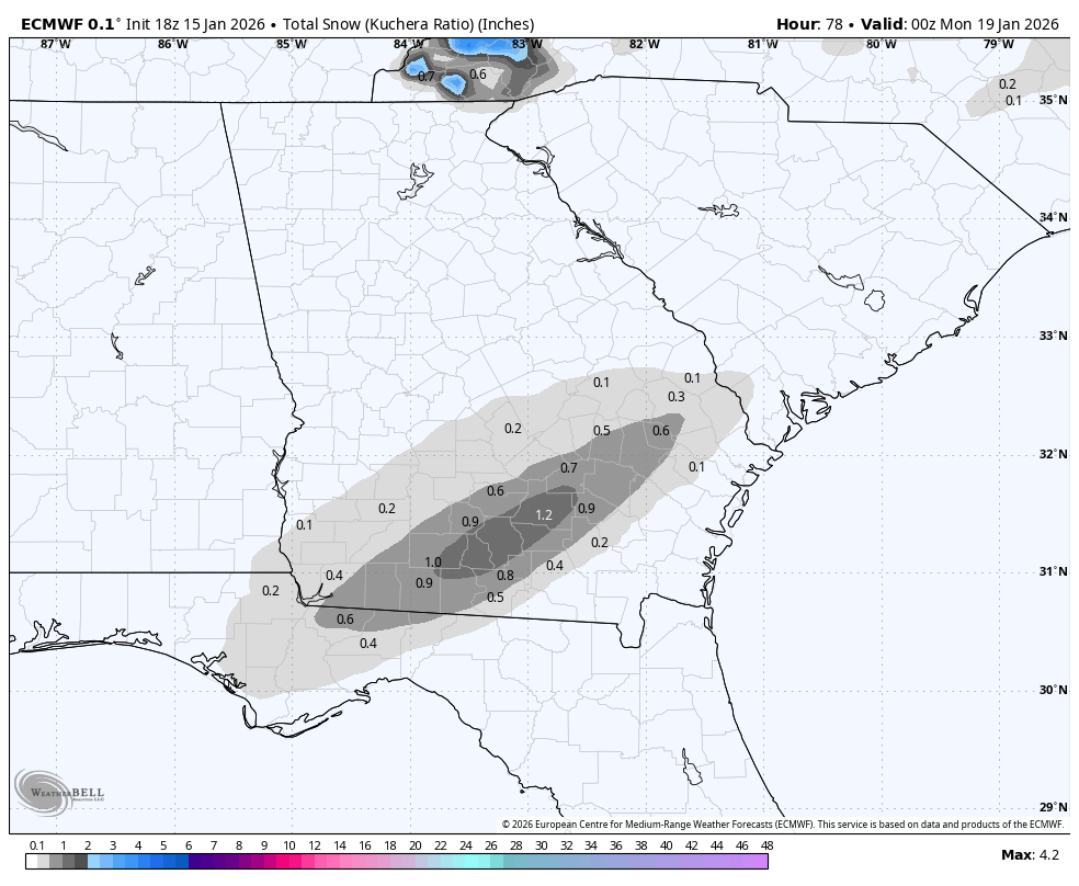
Valdosta, indeed, with 1.7”, is near the 2” max on the 12Z Euro, which had a significant uptick from ~0.5” the prior 3 runs (see below). If they were to get that, it might be the 2nd highest on record next to the 2.2” of last Jan:
-
Alan Huffman’s call:
-
Icon last 4 runs looking better for S GA to WC SC:
-
Thanks, Brick. Even that’s probably overdone in much of the blue area (1”+) due to marginal temps. But that blue area on your 12Z map an hour or so to my west is my tentative target for a Sun PM drive.
-
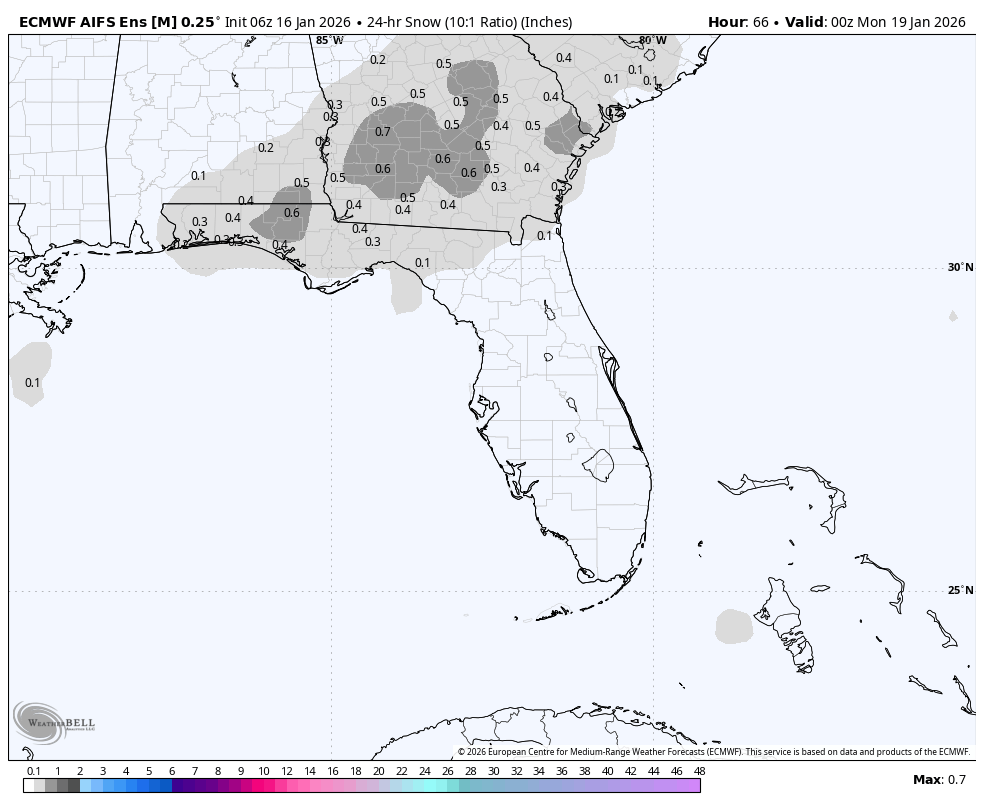
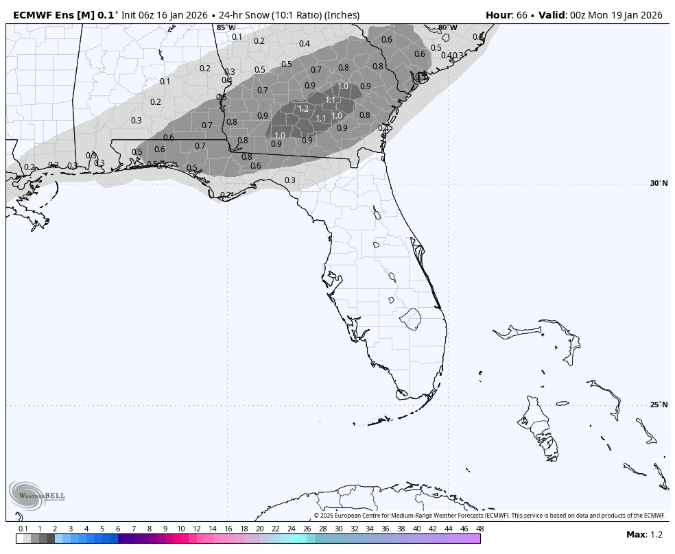
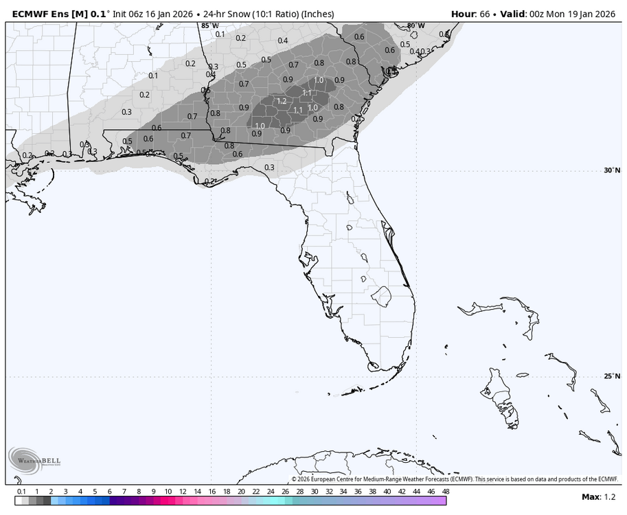
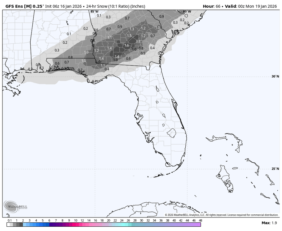
Very rare S GA snow: will it happen? This potential is exciting, but accumulations are probably overdone. I’ll be considering driving to it if it’s within a 1-1.5 hours drive out I-16 assuming the roads are not too affected, which is my guess due to marginal 2m temps. Right here, I’m hoping for a few flurries mixed in with the rain, but there could easily not be any snow mixing in as it doesn’t look quite cold enough right now though I’ll keep monitoring for model changes: 6Z 1/16 EPS: 6Z 1/16 GEFS: 6Z 1/16 Euro AI ens is more realistic imho with lower accums (<1”) but even that would be a rare event:
-
18Z Euro would be a dream come true for some S GA snow lovers with a max of 1.2” at Douglas (see below). I’m not betting on that much accumulating there but we’ll see. How often has Douglas received 1.2”+? Not very at all as the ~120 year wx history shows only 5 times meaning a 1.2” snowfall there would be ~1 in 25 year occurrence. However, all five have been since 1973 meaning that would be a ~1 in 10 year occurrence over the last 52 years: 2/10/1973: 3.0” 12/22-23/1989: 3.3” 2/13/2010: 1.5” 1/3/2018: ~3” 1/21-2/2025: 4.5”

-
Very interesting. Recon is going to be flown out tomorrow afternoon and late tomorrow night to collect extra data to be fed into models probably due to the large disagreement between the King and others: this would affect the 0Z and 12Z runs of 1/17: