GaWx
-
Posts
18,422 -
Joined
Content Type
Profiles
Blogs
Forums
American Weather
Media Demo
Store
Gallery
Everything posted by GaWx
-
I assume you realize that you turned out to have the right idea with Knoxville's actual low being 0 and Tri's actual low being +3 vs yesterday's 12Z GFS progging -14/-13. I counted at least the four prior runs as well as the 18Z having something similar. However, interestingly in case you didn't see it, the subsequent 3 runs starting with the 0Z suddenly warmed ~10 and thus were much closer to reality. We agree that it takes near perfect radiational conditions for the GFS to be close in these situations when it's extremely cold. That may have happened in some cities of TN from what I've read. If anyone could be more specific about these cities and post the 1/16 12Z GFS prog compared to what verified, please let us know. But most of the time, extreme GFS runs like that 12Z run you noted for Knoxville and Tri seem to end up quite a bit too cold. I first learned about this cold bias over fresh snowcover from a pro met whom I know. I see that the -14 progged Knoxville low was a whopping 44 BN! So, the actual low of 0 was a "mere" 30 BN.
-
January Medium-Long Range Discussion
GaWx replied to Holston_River_Rambler's topic in Tennessee Valley
Indeed! Here was the Dec 26th run of the Euro Weeklies for Jan 15-22: Right after this, the Euro Weekly runs for Jan 15-22 progressively got much colder. Just one week later (Jan 2), there was this for the same period: And here’s the final map for the same period, which was released two days ago (Jan 15th): So, in hindsight, the Weeklies map released on Dec 26th ended up a humongous warm bust and it was issued only 20 days prior to the start of the very cold week! When combined with the tendency for somewhat of a warm bias on the Weeklies, there’s no telling what mid Feb+ will bring.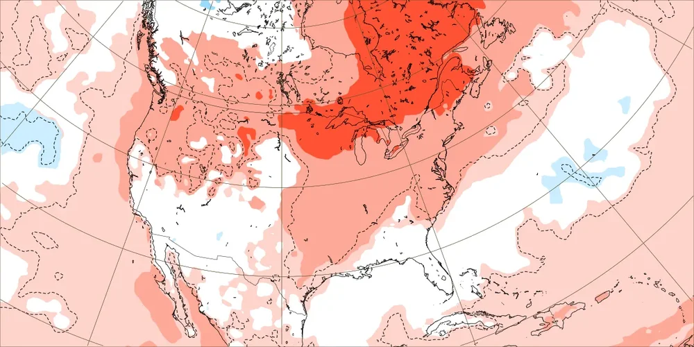

-
More on these 9 (moderate or stronger Nino with no measurable snow Dec and Jan): -Even though 1/3 of them had less snow than climo Feb 15+, the 9 together still averaged almost a normal full season just for Feb 15 through April with 5.4”. This compares to an average of 3.6” for Feb 15+ for the 22 moderate+ Nino seasons that had measurable SN in either Dec or Jan. So, keep the snow away til Feb lol. -Keep in mind that even the 3.6” is ~1” snowier than climo for all years for just Feb 15+. So, the 5.4” for Feb 15+ for the 9 years is double climo. -Feb/Mar temp anomalies for these 9: 1903: +1/-3, 1914: -6/-6, 1915: +1/-9 1919: -3/+1, 1924: -4/-3, 1941: -6/-7 1952: 0/-3, 1983: -4/-1, 1992: +1/-1 Avg of the 9: Feb -2/Mar -4
-
OISST for 3.4 has been dropping quite a bit meaning a super is still not yet a lock even if still likely:
-
Twice for non measurable: -1948-9, 1949-50 -1990-1, 1991-2 -11 seasons without measurable -So, 2 of 11 seasons w/o measurable had no measurable the subsequent winters https://www.weather.gov/wrh/Climate?wfo=rah
-
RDU had no measurable snow in both Dec and January during 9 of the 31 moderate or stronger El Niños since 1888-9. Here’s how much measurable they got Feb+: 1903: 0” 1914: 17.2” 1915: 14.3” 1919: 3.3” 1924: 4.5” 1941: 1.8” 1952: 4.7” 1983: 11.8” 1992: 0” So, 3 of the 9 had big late winters. In the list above, 1914’s 17.2” is the snowiest Feb+ of the 31 moderate+ Nino winters on record while 1915’s 14.3” is 2nd snowiest of the 31. 1983’s 11.8” is 4th snowiest. So, 3 of the 4 snowiest Feb+ moderate+ Nino winters had no snow in both D & J. OTOH, 2 of the 9 were shutouts (1903 and 1992). (Of the 31 total, 7 had no snow Feb+.) The average Feb+ for the 9 Dec-Jan shutouts was 6.4” or near the longterm average. Most of this (average of 5.4”) occurred Feb 15+. So, 2024 may very well be a very long season. But as shown above, the average is derived from a wide range from 1/3 of them being very big late seasons and 2/9 of them being shutouts. It will be interesting to see where 2024 ends up.
-
Indeed, that swing in Feb-Mar of 2021 of nearly 11 in just 29 days was amazing. About the only comparable swing I’ve seen is this one: 2/15/56: -4.6 3/2/56: +4.7 This one was a swing of 9.3 in just 16 days. Arguably, this one may be even more amazing.
-
There have been only 6 -NAO winters during the last 44 (only 14% of them) since 1979-80. The prior 30 winters included 16 -NAO (53%) winters! OTOH, the % of summers with a -NAO has gone up sharply. From 1950-2006, there were only 15 (26%) -NAO summers. But just since 2007, there have been 12 (71%) -NAOs during summer! Something significant has changed at both the winter and summer seasonal levels to affect the NAO in opposite ways. This isn’t just from randomness. https://www.cpc.ncep.noaa.gov/products/precip/CWlink/pna/norm.nao.monthly.b5001.current.ascii.table
-
If we weren’t in a strong El Niño, I might agree. However, based on the RDU average snow strictly for moderate or stronger El Niños (31 of them…so a large sample), I have to respectfully disagree about Valentine’s Day being a crucial day this year: Nov: 0.2” Dec: 0.9” Jan: 2.0” Feb 1-14: 1.0” Feb 15-28(9): 1.4” Mar: 1.7” Apr: 0.4” So, during these winters, the 2nd half of Feb (the month with the most snow on average despite it being the shortest month) actually averaged more than the 1st half. It may even be the most active half month of the entire winter. And then there’s still March, a pretty active month, itself.
-
Looking at the daily indices during 6”+ RDU snowstorms since 1950: whereas a +PNA was fairly common (though far from being required), a -NAO actually wasn’t. The average NAO was actually pretty close to zero with a fairly even mix of -NAO, neutral NAO, and +NAO. So, whereas a -NAO helps with SE cold, itself, it doesn’t seem to be associated with big SE (at least RDU) snowstorms. That was a surprise to me when I complied the stats a few years back.
-
Per met Alan Huffman's surface compilation of major RDU snowstorms (not talking about ice or sleetstorms meaning sig CAD not necessary) -best bet is for an Arctic high center, preferably strong and sprawling, to come down into the Dakotas as opposed to further west, which allows for cold enough air to soon after reach the SE in advance of potential precip. -as opposed to waiting longer for more modified/stale cold first coming into the W, which also often has trouble getting over the Apps -as opposed to a plunge of the high down into TX/AR/LA, which is often the coldest option but is also usually too dry to allow for moisture return into the lower levels prior to a warmup; high plunges like these often result in extreme cold/dry followed by too rapid a warmup due to warming on the backside of the high -and then for the large Dakotas high to move SE, ESE and then E through the Ohio Valley thus hopefully still keeping it cold enough in the SE at least as high as 850 mb (with or without significant CAD) -at the same time you want moist WSW to SW 500 mb flow over the top of the lower level cold in the SE US while the Arctic high is still in/near the Ohio Valley. If the 500 mb flow over the SE is instead WNW or even W, it usually is too dry in the SE for a big storm if any storm at all -timing is obviously crucial being that big SE snows are infrequent -best bet at 500 mb is for a split flow of the N stream bringing down but not plunging the Arctic high combined with a moist S stream simultaneously bringing in plentiful moisture from the Pacific and especially Gulf over the top of the S extent of the Arctic high -more specifically, a +PNA with a 500 mb trough centered near the Mississippi River is what I look for -Most of the memorable major SE snowstorms are associated with a weak to very weak GOM surface low that doesn't go too far inland, if inland at all other than over FL. These are usually Miller As.
-
-This pattern is further evidence of the already known GEFS bias toward too strong of an SPV. -Latest GEFS (your blue line) has dropped to a not too shabby -2.5. It may drop a little more in tomorrow’s run. -This is a 10 mb reversal along with a split but without a simultaneous 10 mb warming. So, I don’t know whether Jan of 2024 will be credited in datasets as having had a major SSW. -There already was an impressive 10 mb warming 12/29-1/6. Since there was no reversal then, that was initially considered a minor SSW. And now comes a reversal 10 days later. -Could this be counted as a lagged major SSW when all is said and done? Quite possibly. There was a warming peak in late Jan of 2010 and the attendant 10 mb winds dropped to ~+1 to +2 m/s but the actual reversal wasn’t til ~2/9/2010. This is counted in some datasets as a late Jan 2010 major SSW and in others as a Feb 9, 2010, major SSW. - Will there be a detectable lagged effect on the troposphere (a new -NAO/-AO combo) later? The average lag is ~2 weeks but it can take 4 weeks. Fwiw, the last few Euro Weeklies have shown a new -NAO/-AO combo for Feb 12-26, which would mean a start ~3.5 weeks after the Jan 16th reversal. Here’s today’s update of the non-Euro models, which again all show a reversal Jan 15-16:
-
# of 6"+ snowstorms RDU moderate or stronger Ninos: 12 of 31 1880s: 1 1890s: 1 1900s: 0 1910s: 3 1920s: 0 1930s: 1 1940s: 1 1950s: 0 1960s: 2 1970s: 1 1980s: 2 1990s-2010s: 0 (six in a row without one, longest on record) So, RDU is overdue for a 6"+ storm during a moderate or stronger Nino, especially in Feb, although Feb of 1987 was a big month that just missed with two 5" storms. Jan of 2010 also just missed with its 5" storm.
-
Regardless of this EPS SER strengthening trend for Jan 24th, all 3 of the 12Z EPS, GEFS, and GEPS still end up with a decent W cost ridge four days later, which may help bring down an Arctic high by ~Feb 1st. Hopefully that holds up.
-
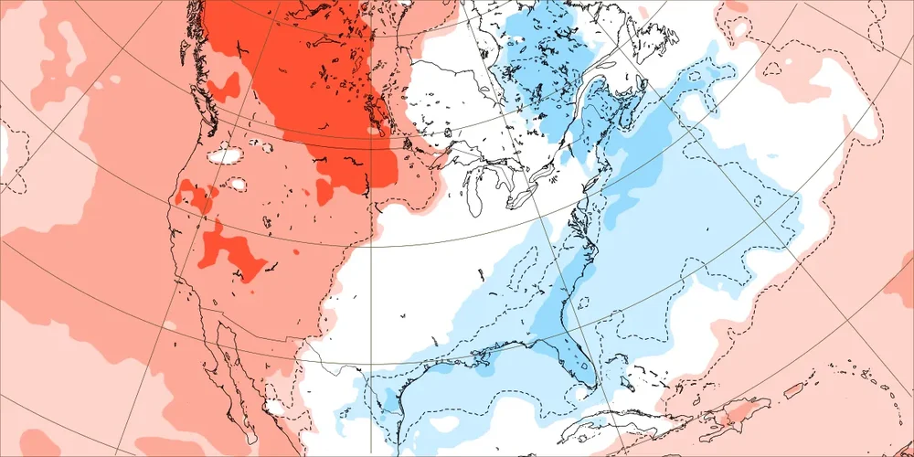
The maps below are from the brand new 12 run averaged CFS for Feb 11-18, which is during/near prime El Niño climo for a major SE winter storm. GOM/FL SLPs are BN, which then moves to offshore the SE US. Note the coldest anomalies being in the Mid-Atlantic, which appears to be a result of Arctic high pressure going through the Ohio Valley, which would be a perfect track as opposed to a plunge. This all suggests GOM/Miller A potential. Yesterday’s Euro Weekly was similar:
-
Today’s non EPS 10 mb strat wind update has 100% of the GEFS members with a reversal on Jan 16th (averaging -1.25 m/s). This is just two days after none of the members had one! The other models also have a reversal Jan 15-16 with the GEPS still the strongest: Edit: today’s EPS agrees a reversal is coming:
-
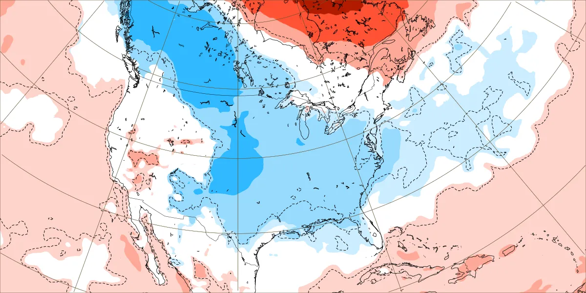
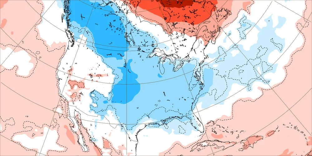
I remember you were also at Peach State Wx. Folks, looking further ahead: A warmup is expected during late January. This has been progged for quite some time as @Met1985just said. Warmups are normal, especially after a 10 day cold dominated period, and considering a then strong MJO 5/6, strong +AO/NAO, and a neutral PNA. Further out (early Feb) and although longer range MJO amp forecasts have been underdone, the MJO is projected fwiw to approach and quite possibly go near or inside the circle (weak MJO tends to be more favorable to E US cold chances than strong MJO despite what’s about to happen). (We’ll see if the MJO really does weaken then.) If it doesn't go inside the circle, it should traverse the colder left side (hopefully not too strongly). For all of Feb, yesterday's Euro weeklies have a solid Aleutian low/+PNA dominating. The SE US gets colder in early Feb. The same weeklies also give a solid -NAO and -AO for Feb 12-26. With the solid +PNA/-NAO/-AO/El Nino combo, the SE is mainly cool to cold then, especially Feb 19-26, along with threats of a GOM/Miller A winter storm. Feb is the most favorable met winter month for cold/snowy in the SE US per non-east based El Niño climo. The last 12 runs of the CFS averaged out have cool to cold dominating the SE US in all 4 weeks of Feb. Although it may be overdone, I can’t recall the last 12 run average of the CFS having a BN SE US in every week. So, it like the Euro Weeklies doesn’t appear to have a cold bias. If that weren’t enough, we’re on the verge of a 10 mb strat wind reversal 1/15-17. Perhaps that is connected to some extent to the -NAO/-AO being progged by the EPS for Feb 12-26.
-
merely a snapshot and is when the same model has the MJO in strong phase 5/6, a strong +AO, strong +NAO, and neutral PNA. So, this map is not at all surprising. A warmup in late Jan has been on models for awhile. Warmups are normal, especially following a 10 day cold dominated period. Just 5 days afterward the same model is forecasting a moderate MJO phase 6, +PNA, neutral AO, moderate +NAO and an Arctic high starting to move into the N Plains. Further out (early Feb) and although longer range MJO amp forecasts have been underdone, the MJO is projected fwiw to approach and quite possibly go near or inside the circle (weak MJO tends to be more favorable to E US cold chances than strong MJO despite what’s about to happen). (We’ll see if the MJO really does weaken then. If not, it should be on the colder left side.) For all of Feb, the Euro weeklies have a solid Aleutian low/+PNA dominating. The E US gets colder in early Feb. The same Weeklies also gave a solid -NAO and -AO for Feb 12-26. Feb is the most favorable month for cold/snowy in the E US per non-east based El Niño climo. The last 12 runs of the CFS averaged out have cool to cold dominating the E US in all 4 weeks of Feb. Although it may be overdone, I can’t recall the last 12 run average of the CFS having a BN E US in every week. So, it like the Euro Weeklies doesn’t appear to have a cold bias. If that weren’t enough, we’re on the verge of a 10 mb strat wind reversal 1/15-17. Perhaps that is connected to some extent to the -NAO/-AO being progged by the EPS for Feb 12-26.
-
Update on OISST: Keeping in mind that ERSST averaged 0.08 warmer than OISST the previous 5 months, I had said OISST likely needed to average under +1.80 Jan 7-31 to prevent a super ONI peak. Jan 7-13 OISST has averaged +1.93. That means that Jan 14-31 would likely need to average +1.75 or lower. With it at +1.93 yesterday, that is doable but the chance is low meaning the chance for a +2.00+ ONI peak (unrounded) remains high as of now. The chance for a rounded +2.0 (i.e., what goes into the ONI table) is, of course, even higher as that likely requires that Jan 14-31 OISST average only +1.62+.
-
So, 0Z GEFS went from this on 1/12: 0% chance of reversal in January To this on 1/13: >60% chance of reversal 1/16-17, which is by far biggest jump and highest I’ve seen it this winter
-
It may very well based on the extended models, non-east based El Niño climo, and the MJO. If not, don’t give up on Magnificent March. One year Amazing April even did it! Plus there are the couple of opportunities in the middle of Jumping January next week for at least something modest. It is still very early and Feb is looking promising. Even Eric Webb is excited about Feb.
-
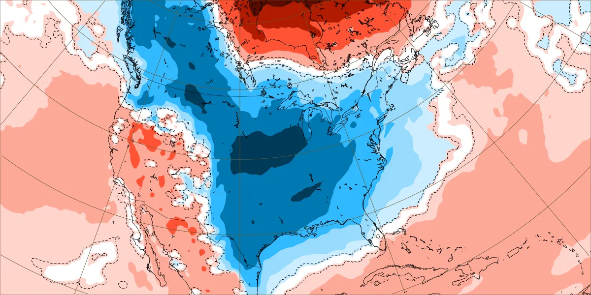
In addition to the very cold upcoming 10 days, the EPS/GEFS implies another Arctic high may drop down near the end of Jan and provide cold in very early Feb. This image is from the new Weeklies for 1/29-2/5. Then it turns normal followed by more cold, especially 2/19-26. Also, every week of the latest 12 run averaged CFS is cold through late Feb with a hint of a Miller A on both in mid Feb. So, opportunities will likely be there after next week’s opportunities for wintry precip.
-
And now today’s non-Euro update says a reversal is likely 1/15-6 (implications for Feb? though technically may not be SSW) with a strong majority of members below 0 as the big change was the GEFS joining the others as 17 of 23 of them go <0 vs none yesterday:
-
-For RDU for the 31 El Niños that were moderate or stronger, keep in mind for snowfall that only 29% (2.2”) fell on avg through 1/20 with 5.4” 1/21+. -Regarding the 15 (one every other winter) 6”+ storms, median date not til Feb 10-11 -More 6”+ events in Mar (4) than Feb (3) or Jan (3) -Peak 10 day frequency for 6”+ 2/21-3/2 (4)
-
The snow is one thing but this is miserable cold. I enjoy cold a lot (I enjoy walking in it) and always root for a cold winter as that’s exciting, but I mean by SE standards. The Sun-Mon highs in the teens, especially with wind/no sun, and lows of 5-6 are overdoing it a bit for my taste. I don’t know that I’d walk in that though walking in snow, something I haven’t had many opportunities to do, would be fun and might still tempt me. I can’t even imagine going out in the Chicago cold coming then!