GaWx
-
Posts
17,545 -
Joined
Content Type
Profiles
Blogs
Forums
American Weather
Media Demo
Store
Gallery
Everything posted by GaWx
-
For the first time in 8 days, OISST updated at cyclonicwx. On the prior update, it was at +1.64 as of Nov 8th, which turned out to be a short term low just like the WCS short term low of Nov 7th. Its latest (Nov 16th) is a little cooler than WCS’ latest with +1.81 vs +1.89. Its high was +1.83, which was set yesterday. So, like on WCS, it warmed ~0.2C during that week. Looking back at the last few months in 3.4, WCS has tended to be very slightly warmer (~0.05 on average) than cyclonicwx although the latest is .08 warmer.
-
Varying opinions make for interesting and active forecast discussions. This topic would have nowhere near as many posts as it has had without significant differences of opinion. I do not look forward to the day when seasonal forecasts from models become much more accurate/they all predict the same thing. If that is to ever occur, that would make forecast discussion topics pretty boring.
-
I don’t see how Aug/Sep can end up THE peak for both Nino 3.4 and Nino 4. They’ve both been warmer in Nov than Aug/Sep. Nino 3.4 per OISST just hit a new daily high of +1.89 on Nov 15th: https://www.cpc.ncep.noaa.gov/data/indices/wksst9120.for
-
WCS 11/15 updates: -Nino 3.4 OISST barely warmed from +1.88 24 hours earlier to +1.89, which is its warmest so far this Nino. Although it has warmed a decent amount over the 8 days, this slowdown may mean it is topping at least for now. -The PDO rose slightly from -1.27 to -1.25. -I’m sticking with a +1.7 to +1.9 ONI peak for now.
-
After several runs in a row with TCG from this, the 12Z UKMET dropped TCG.
-
0Z UKMET: not a H as was on the 12Z, but still maxes out as a 51 knot 984 mb TS once past Bermuda. Before that, it is near Bermuda as a solid (993 mb) TS: NEW TROPICAL CYCLONE FORECAST TO DEVELOP AFTER 54 HOURS FORECAST POSITION AT T+ 54 : 21.5N 74.5W LEAD CENTRAL MAXIMUM WIND VERIFYING TIME TIME POSITION PRESSURE (MB) SPEED (KNOTS) -------------- ---- -------- ------------- ------------- 1200UTC 18.11.2023 60 22.5N 72.7W 1002 35 0000UTC 19.11.2023 72 28.4N 67.5W 997 44 1200UTC 19.11.2023 84 34.3N 62.1W 993 46 0000UTC 20.11.2023 96 42.5N 54.4W 984 51 1200UTC 20.11.2023 108 51.5N 46.1W 988 49 0000UTC 21.11.2023 120 POST-TROPICAL
-
12Z UKMET says this may become a H near or past Bermuda: 68 knots/978 mb: EW TROPICAL CYCLONE FORECAST TO DEVELOP AFTER 54 HOURS FORECAST POSITION AT T+ 54 : 19.2N 77.5W LEAD CENTRAL MAXIMUM WIND VERIFYING TIME TIME POSITION PRESSURE (MB) SPEED (KNOTS) -------------- ---- -------- ------------- ------------- 0000UTC 18.11.2023 60 19.4N 76.3W 1003 33 1200UTC 18.11.2023 72 23.4N 72.2W 999 43 0000UTC 19.11.2023 84 29.0N 67.0W 989 53 1200UTC 19.11.2023 96 37.5N 60.9W 978 68 0000UTC 20.11.2023 108 48.0N 53.0W 979 58 1200UTC 20.11.2023 120 CEASED TRACKING
-
It actually warmed only ~0.01C in 2 weeks from ~+1.87C on 11/1 to +1.88C in today’s update. But it has warmed ~0.2C during the last week.
-
WCS 11/14/23 updates: -Nino 3.4 OISST warmed from +1.85 to +1.88, which is barely warmer than Nov 1st and thus is the warmest so far this Nino -The PDO dropped from -1.19 to -1.27. It has dropped a pretty good bit over the last few days from when it was in the -0.90s.
-
JAMSTEC actually had a bit larger area of +3+ in the Oct run (see below). It looks to my eyeballs like the implied Nino 3.4 DJF forecast is about the same as what the Oct run had. Oct was at +2.05 per this: https://iri.columbia.edu/our-expertise/climate/forecasts/enso/current/?enso_tab=enso-sst_table Nino 3.4 is probably again only slightly warmer than +2.0 on this like it was on the Oct run although I think that’s going to verify too warm. A very low +2.0s Nino 3.4 can easily have a small area near +3.0 along the equator since it is the warmest area and negates the mainly W portion that is under +2.0. Oct forecast: +2.05 in Nino 3.4 Nov forecast: likely similar to the +2.05 of Oct in 3.4
-
Here’s something for which I can’t recall the last time it occurred: every one of the 5 weeks of today’s Euro Weeklies has cooled in the E US vs yesterday’s run and is easily the coolest overall run in the E US in a very long time. Instead of warmth dominating the run like for many recent runs, near normal dominates in today’s. For example, look at how much 11/20-7 cooled: Today’s 11/20-7: Yesterday’s 11/20-7:
-
Latest WCS as of 11/13/23 about steady vs yesterday for both Nino 3.4 (at +1.85) and PDO (at -1.19).
-
That’s probably why studies I’ve seen often refer to the average of the preceding OND to gauge the strength of the IOD. Thus, there’s almost no doubt that this IOD will end up as one of the strongest on record/very strong relative to other years.
-
Yeah, I use the CPC based on difference between Iceland and Azores SLP for it. They’ve done well for me.
-
I was purposely just listing El Niño years in my 2nd paragraph and beyond. But despite my not expecting it, I also remain hopeful for a sustained -NAO. Anything and everything can occur this winter. El Niño with -QBO probably tilts the scale a little bit. As it is, I’m thinking good chance for a Feb -NAO, regardless.
-
A gutsy call since I assume you realize that even the low end would mean the strongest -NAO for D-M since 2012-3. I’d love for you to be right during these hard to come by -NAO winters. What a winter the E US could have with that! The only El Niño D-M since 1951-2 with a -NAO stronger than the top of your range all had BN temps in most of the E US: 1957-8, 1963-4, 1968-9, 1969-70, 1976-7, and 2009-10. These are the El Niño D-M with an NAO within your range: 1958-9, 1965-6, 1977-8 All 3 of these were also BN in much of the E US. Corrected
-
Thanks. Did you mean to say slightly negative for Dec-Mar?
-
Indeed. That’s why I think the odds of a -NAO this winter are pretty low despite the fact that I think this winter will still be ascending (based on Waldmeier effect) and would be content with a neutral NAO. Four of the last six (back to 1979-80) -NAO DJFs were during ascending but as you alluded to, they were only 4, 13, 13, and 25 months past minimum. This winter will be centered on 49 months past minimum. But despite that, I’m also not giving up hope on a -NAO winter mainly because two of the four similarly timed QBO El Niño winters (1986-7 and 2009-10) had a -NAO DJF and both were ascending (though only 4 and 13 months past min, respectively). That’s not too shabby though the sample size is very small. 1991-2 and 2014-5 El Ninos had similar QBO but both had a +NAO in DJF. However, both of these +NAO similar QBO El Nino winters were during descending solar (14 and 9 months after max, respectively) interestingly enough. Hmmm…
-
Have you made a specific forecast for either the DJFM or DJF NAO? I know that @40/70 Benchmarkis going with neutral for DJFM (+0.15 to -0.20), which I’d take in a heartbeat in this day and age of difficult to attain -NAO winters. I don’t recall any other explicit (with numbers) NAO forecasts to this point. Getting a -NAO in DJF has occurred only six times in the last 44 (14%) winters though two of the six occurred in -QBO El Niño winters (1986-7 and 2009-10). In DJFM, there have also been only six of the last 44 as -NAO though only one during El Niño (2009-10) as 1986-7 dropped out due to a neutral March. I define -NAO as sub -0.25 averaged out over the relevant period. So, of the last 14 El Niño DJFMs, only one was sub -0.25. Fwiw, I’m leaning -NAO in Feb but either neutral or +NAO in DJF. So, I’d take a neutral DJF.
-
Latest WCS updates as of 11/12/23: -Nino 3.4 cooled back from +1.87 to +1.82 -PDO had the biggest drop for a single day since mid Sept from -1.01 to (per Griteater’s post) -1.18
-
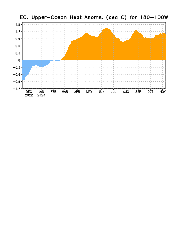
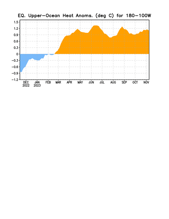
Updated CPC OHC graph: latest warming topped out. Is this only a temporary halt or is it the start of new cooling?
-
This is similar to the cooler week on the Euro Weeklies on today’s run where it went from AN to NN. So, not as cool, but same trend toward cooler than prior runs for the end of Nov/start of Dec.
-
For the first time I can recall, the UKMET (12Z) has TCG for this in their textual product. Actual TCG isn’t until the C Bahamas after which it moves NE toward Bermuda as a 994 mb TS: NEW TROPICAL CYCLONE FORECAST TO DEVELOP AFTER 144 HOURS FORECAST POSITION AT T+144 : 22.3N 73.6W LEAD CENTRAL MAXIMUM WIND VERIFYING TIME TIME POSITION PRESSURE (MB) SPEED (KNOTS) -------------- ---- -------- ------------- ------------- 1200UTC 18.11.2023 144 22.3N 73.6W 1001 32 0000UTC 19.11.2023 156 25.2N 69.9W 1000 40 1200UTC 19.11.2023 168 30.0N 64.9W 994 42
-
Daily NAO back to 1950: https://ftp.cpc.ncep.noaa.gov/cwlinks/norm.daily.nao.index.b500101.current.ascii When comparing these to the monthlies, the average of the dailies typically has ~half the amplitude of the monthlies. For example, the tabular monthly has a -2.03 for October of 2023 vs the average of the dailies being ~-0.9. For August of 2023, whereas the tabular monthly is -1.16, the average of the dailies is ~-0.6. Links to other dailies: https://ftp.cpc.ncep.noaa.gov/cwlinks/ The average of the PNA dailies similarly has ~1/2 the amp of the table. Oddly enough, the AO is unlike the NAO and PNA with the average of the dailies being close to the table.
-
For the first time on any run back to Oct 28th, the EPS weeklies have near normal instead of above normal temperatures most favored for the week 11/27-12/4 throughout the E half of the US fwiw: