

GaWx
-
Posts
18,792 -
Joined
Content Type
Profiles
Blogs
Forums
American Weather
Media Demo
Store
Gallery
Everything posted by GaWx
-
0Z UKMET: big changes as it now skirts S coast of Jamaica, about worst possible track for them and would easily be worst hit there since Dean of 2007. Also, now crosses NE Yucatan on way to a central TX landfall with it restrengthening on way to TX. Prior run was Tampico! Ignore the winds (too low) and pressures (too high): MET OFFICE TROPICAL CYCLONE GUIDANCE FOR NORTH-EAST PACIFIC AND ATLANTIC GLOBAL MODEL DATA TIME 0000UTC 02.07.2024 HURRICANE BERYL ANALYSED POSITION : 13.6N 63.8W ATCF IDENTIFIER : AL022024 LEAD CENTRAL MAXIMUM WIND VERIFYING TIME TIME POSITION PRESSURE (MB) SPEED (KNOTS) -------------- ---- -------- ------------- ------------- 0000UTC 02.07.2024 0 13.6N 63.8W 965 95 1200UTC 02.07.2024 12 15.2N 67.7W 977 78 0000UTC 03.07.2024 24 16.3N 71.6W 985 69 1200UTC 03.07.2024 36 17.0N 75.3W 995 51 0000UTC 04.07.2024 48 18.2N 78.8W 1000 47 1200UTC 04.07.2024 60 19.2N 82.7W 1002 42 0000UTC 05.07.2024 72 20.0N 86.0W 1002 40 1200UTC 05.07.2024 84 21.3N 89.0W 1005 39 0000UTC 06.07.2024 96 22.2N 91.6W 1003 35 1200UTC 06.07.2024 108 24.2N 93.8W 1002 38 0000UTC 07.07.2024 120 25.5N 95.6W 998 36 1200UTC 07.07.2024 132 26.3N 96.5W 994 49 0000UTC 08.07.2024 144 27.2N 97.0W 994 51 1200UTC 08.07.2024 156 28.9N 97.3W 995 38 0000UTC 09.07.2024 168 29.7N 98.3W 998 30
-
1) Jamaica H landfalls since 1950, the first two of which were very bad major H hits from the E 1951: Charlie (E to W)(MH) 1988: Gilbert (E to W)(MH) 2012: Sandy (S to N on E end) 2) Jamaica H close misses since 1950: Ivan and Dean very bad hits passing just S: 1950: King (W) 1964: Cleo (N) 1974: Carmen (S) 1980: Allen (N) 2001: Iris (S) 2004: Charley (S) and Ivan (S)(very bad hit) 2005: Dennis (NE) 2007: Dean (S)(very bad hit)
-
CANSIPS H5 for DJF: Aleutian high, moderate -PNA, strong -PDO, SE ridge (especially considering it’s been underdone during La Niña/neutral ENSO for years), +AO, +NAO. And that’s not even assuming the common E US cold bias this and most climate models have been exhibiting for years. Also, it is dry. So, what’s to like? Translation: looks like a crappy winter for the bulk of the E US. I’m not mad as it is what it is. Besides, winter is always my favorite season no matter what!
-
It is now moving at 22 mph!
-
It, indeed, would be nice and I’ll hope for it. Unfortunately though, the 7 years before 2024 with at least one MH in May-July ALL had stronger storms than their respective early storms after July and all but one had stronger landfalls after July: 1. 2005 had early MHs Emily 160 mph and Dennis 145 at peaks. Even as strong as Emily was, 3 later storms were stronger than Emily (185-175)! Regarding landfalls, Emily hit at 130 and Dennis at 140 at their strongest. But Wilma hit Cozumel at 150. 2. 1957’s early MH 125 mph/946 mb Audrey was not as strong as Carrie’s peak 140 mph/945 mb. However, Audrey’s 125 mph landfall was by far the strongest landfall of the season. That is the only case on record for which an early season MH had the strongest landfall of the season. 3. 1926’s early MH Nassau H peaked at 140 and landfalled at 135. But Great Miami H peaked/landfalled at 150 in Bahamas. And the Great Havana H also peaked/landfalled at 150 (in Cuba). 4. 1966’s MH Alma peaked/landfalled at 115. But Faith reached 120 (no landfall) and Inez peaked/landfalled way up at 165 (DR). 5. 2008’s MH Bertha peaked at 125 with no landfall. But 4 later storms were stronger (155-130). 6. 1916 had two early MHs, the stronger of which peaked/landfalled at 120. But the later in season TX H peaked/landfalled at 130. 7. 1996’s MH Bertha peaked at 115 and landfalled in NC at 105. But 3 later storms peaked stronger (145-120) and Fran landfalled at 120 in NC. May-July major ATL hurricanes: https://www.wunderground.com/hurricane/articles/early-season-major-hurricanes
-
Thanks for posting this (6/26-30 avg for 2N to 2S). I see that the the upper 50-75m E of 140W and the upper 100-125m W of there is still surprisingly warm for a supposed oncoming La Nina even knowing it isn’t a “relative” map. See the top map below to see how it compares to 6 days earlier.
-
Indeed. Interestingly, it appears that the record high RONI minus ONI was +0.53 set in DJF of 1975-6.
-
12Z UKMET vs 0Z: slightly further N with a little closer to Jamaica and landfall on Yucatan just N of Belize instead in N Belize; final landfall Tampico: HURRICANE BERYL ANALYSED POSITION : 12.1N 60.5W ATCF IDENTIFIER : AL022024 LEAD CENTRAL MAXIMUM WIND VERIFYING TIME TIME POSITION PRESSURE (MB) SPEED (KNOTS) -------------- ---- -------- ------------- ------------- 1200UTC 01.07.2024 0 12.1N 60.5W 963 91 0000UTC 02.07.2024 12 13.7N 63.8W 981 71 1200UTC 02.07.2024 24 15.1N 67.7W 986 65 0000UTC 03.07.2024 36 16.0N 71.8W 993 59 1200UTC 03.07.2024 48 16.5N 75.7W 998 52 0000UTC 04.07.2024 60 17.3N 79.0W 1000 45 1200UTC 04.07.2024 72 18.0N 82.9W 1001 37 0000UTC 05.07.2024 84 18.1N 86.0W 1001 37 1200UTC 05.07.2024 96 18.7N 88.4W 1004 33 0000UTC 06.07.2024 108 19.4N 91.7W 1005 36 1200UTC 06.07.2024 120 20.5N 93.5W 1006 40 0000UTC 07.07.2024 132 20.9N 95.6W 1006 35 1200UTC 07.07.2024 144 21.7N 97.0W 1006 32 0000UTC 08.07.2024 156 CEASED TRACKING
-
I as a near coastal resident obviously would want that to be the case. But even then a later storm with a 140 mph landfall instead of 150 would of course still be potentially quite devastating/just about as bad. The bar for this season is so high now that not getting another landfall as strong isn't necessarily saying much.
-
Thankfully it is moving along at a pretty fast clip of 20 mph thus shortening the duration of effects on the Windwards somewhat vs what would have occurred with slower movement.
-
0Z Euro: a little S of Jamaica to Belize to Tampico. 0Z UKMET also into Belize.
-
Impending very sad and scary situation for those islands. But at least it has weakened a little for now. Fingers crossed it won’t restrengthen before passing them. It’s going to be bad enough as it is barring a near miracle.
-
As expected they just canceled the planned 7/3 stop in Jamaica. However, somewhat to my surprise they kept the 7/2 stop in Grand Cayman. I thought they’d probably also cancel that to be extra conservative to at least stay far enough away from higher waves. So, they’ll be in Cozumel on 7/1, GC on 7/2, and have an extra day at sea on 7/3.
-
Total # of NS through July 1st (excluding NS before May 1): 2024: 3 with small chance for 4 due to 96L 2023: 3 2022: 3 2021: 5 2020: 4 2019: 1 2018: 1 2017: 2 2016: 3 2015: 2 2014: 1 2013: 2 2012: 4 2011: 1 2010: 1 2009: 0 2008: 1 2007: 2 2006: 1 2005: 2 2004: 0 2003: 1 2002: 0 2001: 1 2000: 0 1999: 1 1998: 0 1997: 2 1996: 1 1995: 1 AVG 1995-2023: 1.5 So, going back to 1995, only 2021, 2020, and 2012 had a higher #.
-
The June 2024 SOI came in at -5. For La Niña immediately following El Niño since 1876-7 with a 3 month 3.4 SSTa dip to -1.0 or lower (using RONI for 1949-50+), here was the preceding June SOI: 1886: +4 1889: +18 1924: +7 1942: +7 1970: +9 1973: +10 1983: -3 1988: -4 1998: +8 2007: +5 2010: +1 2016: +4 AVG: +6 So, the June 2024 of -5 is much higher than the June SOI avg of +6 for moderate to strong La Niña immediately following El Niño. However, it is only barely higher than the -4 of June 1988 and the -3 of June 1983. So, there’s still a reasonable shot at a RONI dip to -1 or lower this autumn though that chance has clearly dropped over the last month.
-
Guess where Beryl is:
-
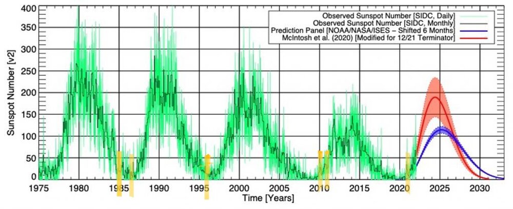
I took the sunspot cycle graph I posted above and drew in yellow lines when the 6 -NAO winters since 1979-80 occurred to give a better view of where they were in the solar cycles. You can clearly see that they were all during the weak parts of all of the cycles (1-2 during each weak period): sunspots averaged only 18 (range 6-33) vs 1900-2022 avg of 85 and were within 2 yrs of a min:
-
This is what I posted in last year’s ENSO thread on 8/23/23: Over the last 44 winters, -NAOs (I define as sub -0.25) for DJF have been few and far between: 1984-5: (NAO -0.70) (moderate La Niña) headed down in cycle 21 with limited sunspots averaging only 20/month; this was 20 months before the minimum of Sept 1986 1986-7: (NAO -0.30) (moderate El Niño) very early in cycle 22 four months after the Sept 86 minimum with very limited sunspots of only 6/month 1995-6: (NAO -0.62) (moderate La Niña) headed down in cycle 22 with limited sunspots of only 12/month nine months before Sept 1996 minimum 2009-10: (NAO -1.67) (strong El Niño) one year into cycle 24 at 13 months after the Dec 2008 minimum just starting to head upward but with still limited sunspots of only 22/month 2010-11: (NAO -0.68) (strong La Niña) two years into cycle 24 at 25 months after the Dec 2008 minimum headed further up but still low at 33/month 2020-1: (NAO -0.42) (moderate La Niña) early into cycle 25 at 13 months after the Dec of 2019 minimum just starting to head up but still with limited sunspots of only 14/month --------------------- Note that there has been either one or two -NAO winters during each of the last four quiet portions of the cycles! So, based on the last 44 years of -NAO winters, the data clearly shows that being within two years of a minimum (ascending or descending) along with limited sunspots (so, nowhere near a cycle max) has given the best chance for a -NAO winter. The average distance from minimum was only 14 months. So, for these last six -NAO winters, the average monthly sunspots were all low to very low: 20, 6, 12, 22, 33, and 14 for an average of only 18. This 18 compares to the longtime average monthly sunspots of 85 (based on 1900-2022 data). Monthly NAO since 1950: https://www.cpc.ncep.noaa.gov/products/precip/CWlink/pna/norm.nao.monthly.b5001.current.ascii.table Monthly sunspots: https://www.sidc.be/SILSO/DATA/SN_m_tot_V2.0.txt @Stormchaserchuck1@Terpeast
-
Thank you, Chuck. Great stuff! This tells me it isn’t a coincidence that the only 6 -NAO winters since 1979-80 were during weak portions of the solar cycle. Thus, I’m looking for the next good shot at a -NAO winter or two to be in the late 2020s to early 2030s.
-
2009-10 & 10-11 were when sunspots were very low to low and 1-2 yrs after a min. Only 4 other winters since 1979-80 had a DJF averaged sub -0.25 NAO and they also all had low sunspots/were within 2 yrs of a min: 1984-5, 1986-7, 1995-6, and 2020-1. All 6 of these -NAO winters had <35 sunspot #/month. Coincidence? 35 is well under the average/median of upper double digits. All of the last 4 solar mins had either 1 or 2 -NAO winters within 2 yrs of the min.
-
Extended summer stormlover74 future snow hole banter thread 23
GaWx replied to BxEngine's topic in New York City Metro
-July 2023 was by far the hottest month of any on record with 102.7. Old record: 99.1 Aug 2020. - June 1974 18 days: hottest SINGLE day avg 100.5 - So we know they’re not even close. The only Q I’d have is how much of the difference could be attributed to increased UHI: -Metro was 1.1 million 1974 but was 5.7 million 2023. https://www.macrotrends.net/global-metrics/cities/23099/phoenix/population -
Consensus for Nov shows coolest in 3/3.4 with warmest in 4.
-
Tropical Storm #Beryl has strengthened and now has max winds of 60 mph. Beryl is the strongest June tropical storm this far east (~47°W) in the tropical Atlantic (<23.5°N) on record. https://x.com/philklotzbach/status/1807023251408683495
-
SOI dailies as expected came up strongly the last few days (avg of +21 last 5 days), largely because of quite high Tahiti SLPs. The peak was 1018.3. Going back to 1991, only 1996 had a higher Tahiti peak in June though 2020 peaked higher in late May. Meanwhile, OISST continues ~+0.4.
-
I just realized there may be a way the cruise gets to all of the ports of call on the itinerary. The planned stops were Cozumel on 7/1, Grand Cayman (GC) on 7/2, Jamaica on 7/3, and NW Bahamas on 7/5. I wonder if they could reverse most of it and do this: Jamaica on 7/1, GC on 7/2, Cozumel on 7/3, and then hightail it out of there to NW Bahamas 7/4. I might suggest that lmao.


