

GaWx
-
Posts
19,136 -
Joined
Content Type
Profiles
Blogs
Forums
American Weather
Media Demo
Store
Gallery
Everything posted by GaWx
-
I called FEMA. -Since March, FEMA has been paying $750 for food losses from storms. Must be done within 30 days of storm. Has nothing to do with whether you have NFIP. -For those in GA who are wondering, FEMA confirmed residents in certain counties in GA (including mine) can apply. -Fulton/Dekalb not on list (at least yet), but Richmond is as well as many others. You can still apply before your county is on list just in case it gets added later. -For all states call 800-621-3362 or apply online at http://disasterassistance.gov/ and click on the red. On phone they’ll tell you if your county is on list. - I think power had to be out 3 days but don’t hold me to that -Supposedly most get the $750 if power was out long enough. It is all or nothing. -If denied, can appeal
-
This was a silver lining of this horrible storm since relatively few homes/people were directly impacted by those horrific 140 mph winds. The lack of wx data where those very high winds occurred is a very small price to pay in comparison, of course. I’d think just about any empathetic person would take that every time besides the folks living there. The faster the speed of movement for a given strength of storm, the lower the winds on the weaker side typically.
-
1. Per NOAA monthlies, Aug 2024 didn’t have anywhere near record +PNA for Aug as it was only +0.63. Since 1950, 18 Augs had a stronger +NAO incl way higher in ‘22 and ‘18: https://www.cpc.ncep.noaa.gov/products/precip/CWlink/pna/norm.nao.monthly.b5001.current.ascii.table 2. Per NOAA’s NAO table 2024’s drop Aug to Sep was still big but not as big as 1976, 1983, and 2022.
-
1 I’m not ignoring it and see no sign of it being ignored. I even posted that even a TS can have major effects, especially very heavy rain 2. Helene was upper end TS strength here and gave us 70% outages. I was out 5 days! 3. In the period when Helene was already forming there was talk here and elsewhere (including by pro met Webb) that she was looking to be messy/broad. So, we’ll see.
-
That one gave my area the heaviest IP/SN (2”) since 12/1989’s 3-5” and the heaviest liquid equiv of wintry precip (0.75” with 0.5” being ZR on 1/3/2018) since the predecessor to the Knickerbocker storm of 1/1922 that gave SAV the worst ZR on record. However, I haven’t had even a T of wintry since then. This drought of nearly 7 years of no wintry incl T is longest on record!
-
The reason I said Oct-Dec as most likely peak based on past is that peak has largely been at 4th-7th + month in a row. With June the 1st, 4-7 would be Sep-Dec. But last 16 peaks have been at 11+ amplitude. So, I highly doubt Sep’s +10 will be peak. Last time peak was 8th+ + month in row was 15 peaks ago (1993). But DJF will almost certainly still be well within +, regardless.
-
Chuck/others, The +8.61 was for Aug. Sep just updated and was +10.36. Based on past, highest chance for peak is within Oct-Dec with smaller chance JF. Even if peaks Oct, DJF should still be +: 2024 -24.56 -25.54 -28.56 -23.42 -6.52 1.95 6.91 8.61 10.36
-
But those weren’t the Weeklies. Rather, those were the Euro seasonal forecasts, which did along with some other seasonal models predict extreme ACE and thus have busted terribly. Ironically though despite ACE only near average now, this season has had extremely high impact in the CONUS unfortunately!
-
I strongly disagree about the Euro Weeklies. Although far from perfect (no model is close to perfect), the Weeklies correctly forecasted the active periods during summer followed by the very quiet late Aug-mid Sept. Then they forecasted correctly the big resurgence in late Sep weeks in advance! Furthermore, Isaac and TD 13 are already in existence. So, I don’t get why you’re saying they’ve busted badly on ACE when they’ve done about the opposite.
-
I finally got my power back just after 8:15 PM last night. Relief! The total outage here was 115 hours. The fridge and freezer were at 70F meaning most of the food was thrown out. Warmest it got inside was only 83 though it was very sticky. But relative to many other areas, this area got off lightly overall from Helene. About 13% in the area remain w/o power.
-
It would be such a relief if this is going to form and hit the CONUS if it would actually hit as a TS instead of a H as that would be the first of the season as you know. I saw the words “mess” and “broad” used in this forum and elsewhere early on for Helene. Hopefully this time that verifies! Of course, I am not trying to minimize the effects of a TS, especially the rainfall. Hoping it will be moving fast enough to keep that under control.
-
Yep, way up the last few days. Aug was at 215 while Sep had sharply dropped to 141. Despite the big increase of SSN back to above 200, the Euro Weeklies mean is forecasting by a large margin the busiest Oct 7-13 in the Atlantic basin at least back to 1991 with ACE well into the 30s, which is more than twice the mean for the peak climo week of a month earlier! We have Kirk, TD 13, and possibly a Gulf low that are all projected to go well into the 10/7-13 week. It will undoubtedly drop sharply afterward but climo favors that, too, in the 2nd half of Oct.
-
1. The QBO is not out yet on any source I look at 2. The dead-cat bounce has been another impressive one in Nino 3.4:
-
Would y’all please discuss this further in the Helene banter thread? That’s the perfect thread for this subject. Thanks in advance. The Atlantic is quite busy and is expected to continue that way.
-
Yesterday’s Euro Weeklies went even higher than the prior 5.0 times climo for 10/7-13 for ACE. It went to 6.3 climo, which is well into the 30s or more than double peak climo week of 4 weeks earlier! Thankfully, the bulk of this is progged to not threaten people although a Gulf TC is progged. The current highest back to 1991 for that week is ~24 and second highest is ~18. Nowhere close: -2018’s ~24 due mainly to Leslie and Michael -2016’s ~18 due to Matthew and Nicole
-
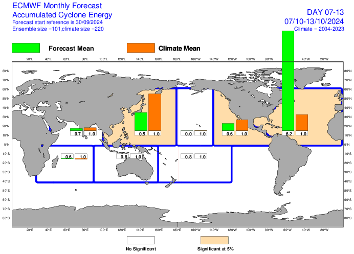
If yesterday’s Euro Weeklies prog of ~30 ACE for 10/7-13 were to verify closely, it would easily be the most active ACE for 10/7-13 since at the very least 1991! Fortunately the bulk is well out to sea. Going back to 1991, the highest ACE I could find for Oct 7-13 were these: -2018’s ~24 due mainly to Leslie and Michael -2016’s ~18 due to Matthew and Nicole Avg ACE for 10/7-13 during 2004-2023 was no more than 6.
-
He’s right because the seasonal model progs have sucked up at H5, too. 500 mb hts have tended to miss too low in E US just like H85, 2 meters, etc…..pretty much the entire troposphere. When trough shows up at H5 in E US, that often has not verified closely. Can even end up as ridge easily. Look at last winter, when models had strong Aleutian trough at H5. They were way off. So, you can’t even trust the H5 “pattern” on them. CANSIPS is showing Modoki El Niño starting next summer. Am I betting on it? Heck no even though these are SST anoms rather than H5. Of course I’m hopeful and will keep posting about it if it persists but not trusting by any means. I don’t trust long range models for anything though E US warmth has seemingly been verifying more closely.
-
Keep in mind that you’re in a location more much less apt (if apt at all) to be warmer than normal in La Niña. Many of us are concentrating more on closer to the E coast. In my case, I naturally also like to talk about my area, which is more highly impacted to the mild side by a dominant SE ridge. I’ve yet to see a seasonal model for this winter not calling for a mild winter and warmer winter than 23-24 in the SE US overall, which is what I’d expect with a strong -PDO and Niña. That’s the main reason I keep looking ahead to 25-6 for a potentially much colder winter down here with the CANSIPS again literally showing a Modoki El Niño.
-
I ended up with ~6.75” of rainfall this month, with ~5.25” of that just before and during Helene (9/25-7). The other 1.5” fell Sep 5-8, which at the time was the first measurable rainfall since Aug 20th. Highest temperature inside this month has been ~83 with high RH and calm winds due to the still ongoing power outage caused by Helene.
-
Hoping for cooler and less humid as we go later into met. Autumn. Starting off here with dewpoints near 70, more like summer than fall.
-
Extended summer stormlover74 future snow hole banter thread 23
GaWx replied to BxEngine's topic in New York City Metro
This is consistent with the JB playbook: despite predicting an AN temperature winter, emphasize BN potential early based on extreme speculation as well as keep showing cold WB CFS winter maps as they appear, which are much colder than the model is really showing. (He probably doesn’t realize that though.) Shy away from showing CFS maps when the runs aren’t cold. Keep “monkey wrenching” to sew doubt in folks’ minds about a mild winter. Consider cooling the winter forecast by November just like was done for 2020-1. In all fairness that cooling actually ended up closer to reality but that’s bedside the point. Got to keep people clicking. -
For the 2nd month in a row the CANSIPS fwiw has a developing Modoki El Niño (centered near 150-155W in Sept and drifting further W) next summer with it peaking in Sept 2025 or later. It is a little stronger on this run vs last month’s with my rough estimate of +1.0 in Sep in Nino 3.4. On a relative basis, it would probably be more like +0.7. Just food for thought for the winter after next and a reason I’ve been more excited about 2025-6 than 2024-5 for my area’s potential. Now if only the core of the WPAC marine heatwave could migrate E (one can always dream):
-
Holy Moses, check out the most recent Euro Weeklies mean prog for ACE for 10/7-13: way off the charts (5 times the 2004-23 mean for that week)! This is ~30, which is nearly double the mean for the peak week 4 weeks earlier and is by far the highest prog for any run this season for any week to date! Fortunately, the bulk of this very high ACE looks to be well out into the open Atlantic though not all of it as that potential Gulf low will need to watched:
-
Extended summer stormlover74 future snow hole banter thread 23
GaWx replied to BxEngine's topic in New York City Metro
The comparison of this top left WB Feb map (avg of 10 days of runs) and the NCEP lower left Feb (again 10 days of runs) is very telling: -WB CFS has Chicago ~-6F and W TX NN -In stark contrast, NCEP CFS has Chicago only -1 to -1.5F and W TX +4 to +5F -This is further confirmation that WB CFS maps tend to be much colder than what the actual model output shows. This is a big problem because it’s misrepresenting what the CFS is actually predicting. -
Close Niña orientation and QBO notwithstanding: 1. Dec of 2010 barely missed having the strongest Dec -NAO since 1950 with only 1963 and 2009 slightly stronger. In contrast and though it of course is possible, there’s currently no indication that Dec of 2024 will have a -NAO (sub -0.25) at all. This shows the opposite, a very strong +NAO fwiw: 2. With the exact opposite SSN vs 2010, this strong +NAO prog for Dec is very believable.


