

Buddy1987
-
Posts
3,952 -
Joined
-
Last visited
Content Type
Profiles
Blogs
Forums
American Weather
Media Demo
Store
Gallery
Posts posted by Buddy1987
-
-
1 hour ago, WeatherHawk said:
This has been one of the most inactive winters up here in the blue ridge that I can remember.
You ain’t kidding! I can’t even recall a period that even featured light snow at any point this winter, which is insane. You have a pretty good spot setup where it shows your current location is for this. With the wet bulb and isothermal layer, elevation, etc.. I think you will have a period of something wintry.
-
 1
1
-
-
39 minutes ago, PantherJustin said:
It won’t let me post a pic … but it was 6-8” amounts basically 77 west up thru your area in VA
.Ah see.. you gotta watch out for the method and ratios. I’m assuming you used the standard 10:1. This stuff is gonna be like concrete coming out of a mixer like 3:1 maybe 6:1 at the end as some colder air could mix down. Kuchera also helps and if you pull that up you’ll notice a huge difference.
-
7 minutes ago, PantherJustin said:
GFS although from Tidbits ummmm looked much different…. Ik Ik Tidbits but still hell of a change
.What do you mean? I don’t think I’m following you.
-
LONGGGGGGGG range HRRR looks sleety..

-
LONGGGGGGG range HRRR way colder than any NAM product. Very sleety.

-
Just now, Daniel Boone said:
Actually, it should help.
NAM warmer so far at 18Z. I did see Euro however and it did look pretty darn good.
-
1
-
-
NAM can't make up it's mind. Moving in precip much quicker than 12Z did. Don't know if it will make any difference for those that are on the fence with temps and time of day etc..
-
1
-
-
And that about just puts the nail in the coffin with GFS. Maybe higher peaks and around Asheville area but outside that threat is pretty much cooked.
-
 1
1
-
-
High RES GFS (FV3) looks rather similar with band of snow at the end of it's run. Looks like it's trying to exhibit some convective elements in it as well. Kinda let's me know GFS will still have it. Let's see what GFS shows in about 30 minutes.
-
1
-
-
1 minute ago, NorthHillsWx said:
I don’t buy it at all. It’s just simply not cold enough for freezing rain and it will now be falling in daylight. I had held out hope that folks outside of the mountains would get a decent thump and it looked very promising as recently as 12z yesterday but models have trended:
1) Even slower. Now a daytime event Sunday and it gives the cool pool everyone outside the mountains is totally relying on more time to moderate
2) much drier in deform area. Mid levels dry out when you’d think precip would be solid and you end up with no snow to bring cold air down, a huge issue with temps
3) Further NW with low tracking inland
4) Presence of the dreaded warm nose
Im not saying it’s impossible someone gets lucky but it would seem this threat is dead outside the mountains and even there the snow potential seems half of what it was yesterday through 12z
Hell at this point if I had a 2-4 hr period of moderate snow up this way and we got an inch or two, the way things have gone this year, i'd be elated, BUT I don't even foresee it even up deep into the Blue Ridge. I will reserve final judgment until GFS comes out, because it's been pretty consistent with a heavy band of snow traversing northern and northwestern most areas of the forum once the ULL swings.
-
1
-
-
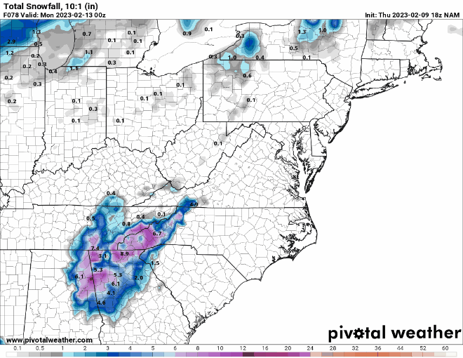
12K NAM Kuchera

-
3K Total Snowfall.. Only thing we can hope for at this point is the Nam is being the Nam but we're starting to get closer to the event..

-
1 minute ago, NorthHillsWx said:
12z NAM went the wrong way. Everything has gone the wrong way since noon yesterday. Looking more and more like a mountains-only deal and even there they will have mixing issues. What a disaster the last 18 hours of model runs has been
I honestly don't even buy the freezing rain potential. It will end up being 36 and rain.. it never fails. What a freakin year.
-
12Z NAM with a 1028 Meso High situated nicely over the IN/OH border. I'm going to be monitoring that to see if it can make a difference as precip nears the areas of concern for wintry weather. So far at 36 precip looks a little delayed compared to 6z.
That tiny high really books it next couple frames and dews are progged to be a couple degrees warmer from last run. This is going the wrong way.
-
Asheville at 8.5” with Kuchera method. Roanoke 7.4. Pretty much entire spine of western NC is 4-8” verbatim with Kuchera on GFS. @BornAgain132-4” type of event down your way.
-
2
-
-
54 hrs mainly has any type of wintry precip confined to mountain areas of far northwestern NC and then into southern Virginia.
nvm spoke too soon hr 60 majority of WNC getting smoked..
-
1 minute ago, wncsnow said:
Hi Res GFS looks pretty bad too through 60. It also has ice for mountains.
You have any idea how it’s verification scores match up to other low level cold models? I’m not sure I’ve ever seen someone in here touch on it. It’s definitely the warmest.
I’d also like to see RGEM and Canadian cool down somewhat. They’ve been running warmer than other guidance as well.
-
1 minute ago, WXNewton said:
18Z NAM to 00z NAM
Let’s us all know it still has a bit of time until it gets more into its wheelhouse. Very positive trends though.
-
1
-
-
3 minutes ago, Sandstorm94 said:
Incoming!
Sent from my SM-S102DL using Tapatalk
NAM has really sped things up this go around. HR 54 has the low about to go over MYR. 18z HR 60 has it over SAV still.
-
Precip a little bit quicker to get into WNC at 51.
-
HR 39 there is a bit better of a push with 2m dew points. Another subtle but very important difference.
Very nice to see northern most Georgia with a dew of 14 at hr45. Encouraging.-
1
-
-
5 minutes ago, Sandstorm94 said:
My thoughts exactly
Sent from my SM-S102DL using Tapatalk
Oddly enough by hr 28 Nam is much drier over MS/AL. Curious to see what happens closer to our areas.
-
2 minutes ago, Sandstorm94 said:
Low is a touch north through hr 21 on the 0z NAM
Sent from my SM-S102DL using Tapatalk
HR 19 you can see very subtle differences with the base of the trough leading to this imo.
-
3 minutes ago, wxduncan said:
So how accurate is the NAM at this range? Because compared to the Euro and GFS this is way west.
I would focus on thermals and not so much synoptics. Someone had mentioned the precip just disappeared at hrs 69-72 and I agree it looks wonky.
2/12 Potential Super Sloppy Bowl fumble with low scores possible!
in Mid Atlantic
Posted
Ain’t no way 5 inches is happening unless your over on top of Mt Rogers in NC or something.. I’d be thrilled with the ground whitened but have reservations even about that..