

Buddy1987
-
Posts
3,952 -
Joined
-
Last visited
Content Type
Profiles
Blogs
Forums
American Weather
Media Demo
Store
Gallery
Posts posted by Buddy1987
-
-
2 minutes ago, WinterWxLuvr said:
Early but that ridge out west is a little sharper. We need a deeper more neg trough. That might help. We will see
500 this does look better thus far at 78 with the western trough axis over western Montana getting more diggy
-
Just now, BristowWx said:
interested if the icon holds this go around.
There’s no telling with that thing LOL
-
Nothing like a powerhouse 1051 HP sliding down into Montana at hr 63 on the Nam. That thing means business. This incoming airmass starting next week is something else seeing some of the projected highs toward next weekend
-
 1
1
-
-
3 minutes ago, Interstate said:
Why? They are not human... if they see something, they are just not going to change because other models do not see it. I am not saying it is right... but you need to look at all models objectively and see where they are coming from.
Because if anything other guidance has trended NW. Believe me I get it could very well end up being correct but there’s a reason WPC labeled it as an outlier. You can see the western trough axis is quite a bit different between the GFS and EURO so it logically makes sense why it would be more southeast. Guess we’re gonna find out who blinks first.
-
Just now, CAPE said:
6z EPS a bit further southeast.

Head scratching.. would’ve thought with other guidance it would trend slightly better. Going the opposite way here.
-
1
-
-
2 minutes ago, TSSN+ said:

LOL! GFS will be in Bermuda next run and CMC will be in Buffalo at this rate.
All joking aside a lot to figure out with multiple pieces on the board as others have alluded to with cutter and then west coast. Hopefully tomorrow we will start to have some better agreement.
-
1 minute ago, psuhoffman said:
Womp womp
wow someone in here killed a bunch of kittens and puppies or something.
We can blame mappy for making it seem like starting a thread for this storm or even mentioning it was no big deal. There’s our scapegoat lol
-
 1
1
-
-
GFS taking it’s sweet time coming out tonight
-
1 minute ago, Maestrobjwa said:
This close in the Euro may not make a jump like that again. I think either it jumps back up tonight or it may be onto the right idea...
No for sure I was just being funny the way we’ve flipped back and forth here last couple days. Got an unfortunate sneaky suspicion euro will end up scoring the coup.
-
1
-
 1
1
-
-
Just now, Ji said:
Gfs is caving. We need models not to trend towards superior euroWatch the 0z gfs cave to the euro today but then the 0z euro show the 18z gfs solution haha! Nothing surprises me anymore
-
1 minute ago, Stormchaserchuck1 said:
00z NAM at 84hr vs 90hr 18z GFS... looks better on the NAM
https://ibb.co/bmg6rjLYea I noticed at 57 on Nam compared to gfs the whole setup at 500 was better so that’s a good start to the night
-
1
-
-
8 minutes ago, Heisy said:
Look how the wave near the dakotas backed up. That would allow for more phasing once it tries to turn the corner. On top of that the tpv press isn’t as strong

.Confluence slightly better once again.
-
1 minute ago, jaydreb said:

P14 or P29 ftw
-
1
-
-
Alright alright let’s see some clown maps for shits and giggles
-
6 minutes ago, Terpeast said:
@Heisy comparing the op to ensembles is tricky because the op will change from to run, sometimes so drastically that the next run may render your analysis moot.
I’ve always been taught that op is more or less good for within 5-7 day lead time and to take with a grain of salt beyond that, only to compare differences or similarities to the ensembles. I like how Heisy remains polite about his opinion and gives some meteorological ideas and reasonings behind it as well. Great job to everyone providing insight and analysis in here. Always appreciated.
-
3
-
-
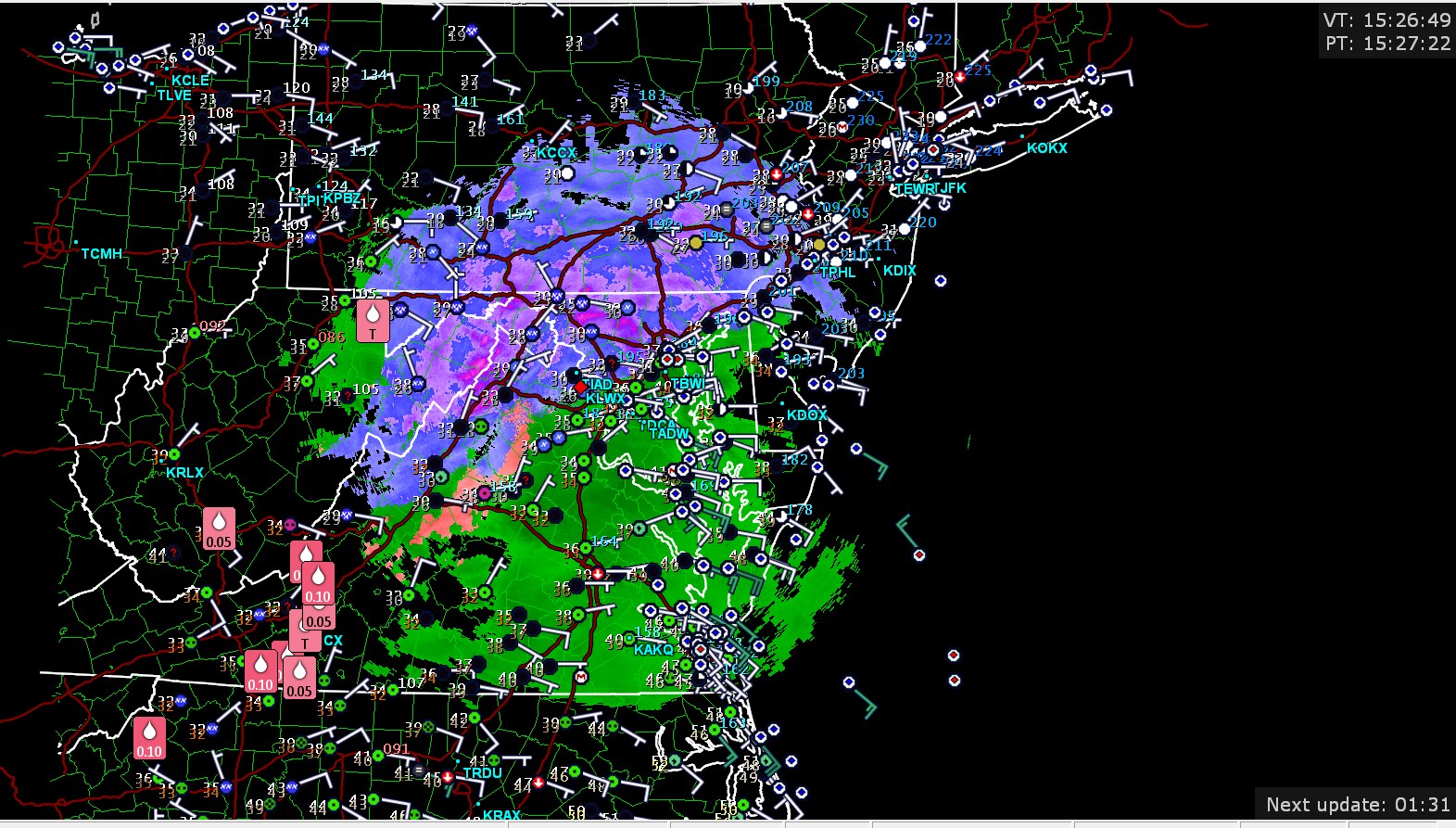
7 minutes ago, Chinook said:
Best of luck to Mid-Atlantic people. Notably, already a reasonably dangerous ice accumulation in SW Virginia.

I can confirm this as well. Moderate freezing rain with a temp of 31 and a heavier band pushing in. Trees starting to get caked.
-
1
-
-
30.0/23.9 SW VA temp has dropped pretty steady down here last 90 min or so.
-
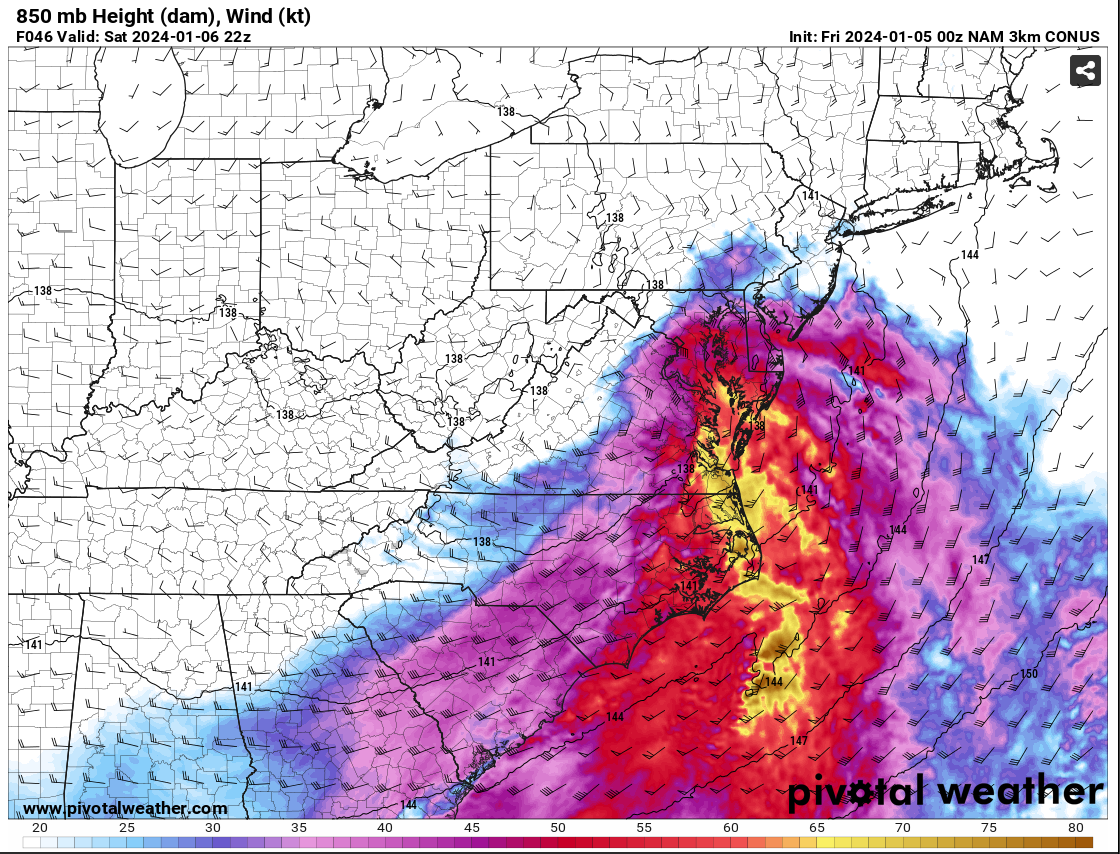
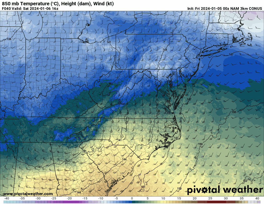
3 minutes ago, MillvilleWx said:
The reasoning for the shift in the colder solution on the NAM is the development of a closed 850mb low tracking south of the Potomac over north-central VA. Pay close attention to the wind barb across the northwest area and how the 850mb southeasterlies hit a brick wall over Parrs Ridge and the wind direction flips. This would allow for cold air to advect into the northern and western side of the circulation creating a more beneficial PBL and keep everything frozen, or even all snow. Check out the wind barbs to the east of RNK...
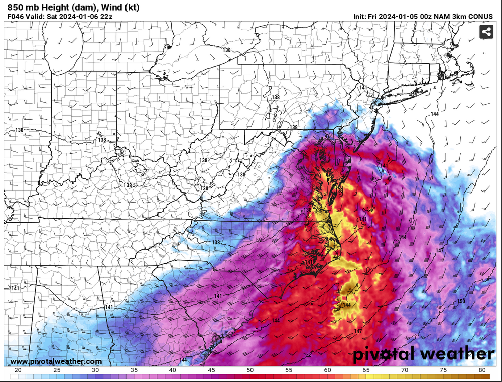
As a result, watch the 850mb temp profile as we work through time. This is actually how you get surprises and periods of heavy snow when you weren't expecting.

MAJOR CAVEAT.... THIS IS JUST ONE RUN OF ONE MODEL!!!
We are going to want to see other guidance pull this off and have it become something to watch. This could be a one run and done deal, but there is potential for this. I will not be committing anything until I see some agreement from other guidance. It was interesting to see and point out as a possibility. It would affect the forecast in a big way. These are why these marginal events are so tricky. One thing can make or break a forecast. Let's hope it's right. Right now, no changes from my current thinking.
Great post! I do feel like with cad setup here Nam does have some superiority or at least some credibility for 850s and 2m specifically. Everything else is really a crapshoot as to what it shows (or what it doesn’t sometimes haha)
-
2
-
-
2 minutes ago, SnowenOutThere said:
The 3k Nam does the @psuhoffman way to victory and keeps the 850s considerably cooler during that critical 3 hour window, just a tick or two more and even the immediate suburbs would be on the snowy side.

That’s a really cool map. You can see the wind barbs feel the effect of the northerly component to the cad. What I would give to have some of the air with the dews up north of VT/NH/ME
-
1
-
-
Just now, nj2va said:
This isn’t an ice storm setup. It’s not like it’s in the teens leading up to this and it’s drizzling for hours. I’d cut those down significantly.
Yea but even half is still not good at all. Normally we’re 60 the day before a freezing rain event. It’s been cold today and tomorrow leading into the event. I just feel like it will surprise some.
-
1
-
-
1 minute ago, Imgoinhungry said:
Wow! How much for frederick?
.Verbatim NAM is a lot more snow up that way with only a glaze of ice.
-
1
-
-
1 minute ago, Imgoinhungry said:
Hmm. Thats weak. A lot of ice in addition?
.Yea def.. looked at pivotal .74 for ROA, .71 CHO area.. .30” plus Culpepper and up 81 Harrisonburg etc all smoked with ice totals.
-
1
-
-
I’m more interested in the thermals with it to see how it handles the cad and it didn’t disappoint tonight.
-
1
-
-
4 minutes ago, clskinsfan said:
Winchester PUMMELLED and beat to death.
WOOF!!! .74 ice accumulation for ROA .71 for CHO.. that happens lights out
Winchester/Clarke/Warren/Woodstock smoked with over 7”
-
2
-
Jan Medium/Long Range Disco 2: Total Obliteration is Coming
in Mid Atlantic
Posted
Sigh..