

beavis1729
-
Posts
2,570 -
Joined
-
Last visited
Content Type
Profiles
Blogs
Forums
American Weather
Media Demo
Store
Gallery
Everything posted by beavis1729
-
And here come the headlines. From NWS Grand Forks...wind chill watch in effect for 5 consecutive days. Wind Chill Watch URGENT - WINTER WEATHER MESSAGE National Weather Service Grand Forks ND 244 PM CST Thu Feb 4 2021 MNZ001>009-013>017-022>024-027>032-040-NDZ006>008-014>016-024- 026>030-038-039-049-052>054-072045- /O.CON.KFGF.WC.A.0001.210206T0000Z-210209T1800Z/ West Polk-Norman-Clay-Kittson-Roseau-Lake Of The Woods- West Marshall-East Marshall-North Beltrami-Pennington-Red Lake- East Polk-North Clearwater-South Beltrami-Mahnomen- South Clearwater-Hubbard-West Becker-East Becker-Wilkin- West Otter Tail-East Otter Tail-Wadena-Grant-Towner-Cavalier- Pembina-Benson-Ramsey-Eastern Walsh-Eddy-Nelson-Grand Forks- Griggs-Steele-Traill-Barnes-Cass-Ransom-Sargent-Richland- Western Walsh- Including the cities of Crookston, East Grand Forks, Ada, Twin Valley, Halstad, Moorhead, Hallock, Karlstad, Lancaster, Roseau, Warroad, Greenbush, Baudette, Warren, Stephen, Argyle, Newfolden, Middle River, Grygla, Red Lake, Redby, Ponemah, Thief River Falls, Red Lake Falls, Fosston, Fertile, McIntosh, Erskine, Bagley, Clearbrook, Bemidji, Mahnomen, Naytahwaush, Waubun, Alida, Ebro, Lake Itasca, Long Lost Lake, Lower Rice Lake, Roy Lake, Upper Rice Lake, Park Rapids, Detroit Lakes, Wolf Lake, Breckenridge, Fergus Falls, Perham, New York Mills, Parkers Prairie, Henning, Battle Lake, Wadena, Menahga, Elbow Lake, Hoffman, Ashby, Herman, Barrett, Cando, Langdon, Cavalier, Walhalla, Drayton, Pembina, Neche, St. Thomas, Fort Totten, Maddock, Leeds, Minnewaukan, Devils Lake, Grafton, Park River, New Rockford, Lakota, Mcville, Aneta, Tolna, Grand Forks, Cooperstown, Finley, Hope, Mayville, Hillsboro, Hatton, Portland, Valley City, Fargo, Lisbon, Enderlin, Gwinner, Milnor, Forman, Rutland, Wahpeton, Edinburg, Adams, and Lankin 244 PM CST Thu Feb 4 2021 ...WIND CHILL WATCH REMAINS IN EFFECT FROM FRIDAY EVENING THROUGH TUESDAY MORNING... * WHAT...Dangerously cold wind chills possible. Wind chills as low as 45 below zero. * WHERE...Portions of central, north central, northwest and west central Minnesota and northeast and southeast North Dakota. * WHEN...From Friday evening through Tuesday morning. * IMPACTS...The dangerously cold wind chills could cause frostbite on exposed skin in as little as 10 minutes.
-
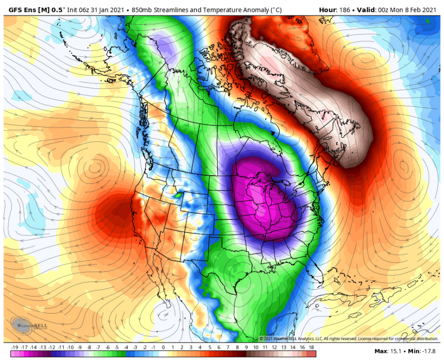
This map is probably overdone with the cold...but I think it's reasonable to expect some -10 to -15 temps in N IL on Sunday morning 2/7. Chicago's record low is -10 set in 1875...could be threatened. Rockford's record low is -16 set in 1972...that could be in jeopardy too. And some nice -52F temps in N Manitoba.
-
I know it's speculation, but you'd think the baroclinic zone would be pushed south...and perhaps strengthen even more (!)...given the expected snowfall over the next 2-3 days.
-
Days like today are where UHI drives me crazy. I’m not even in the core of Chicago metro...and the high/low today has been 37/10 under nearly full sun. But in RFD, it looks like the high/low will end up being 30/2. I know UHI may not explain all of it...but it doesn’t seem like there was much difference in air mass or cloud cover for here vs. RFD. It’s obnoxious. So much non snow covered pavement around here to absorb more of the sunlight, compared to rural areas. Could also be that the south winds today had more snow covered ground to cover out west by RFD, vs. here...although there is a pretty deep snowpack down by IKK.
-
Yeah...to clarify, it's a winter weather thread...so of course people who post in it want wintry weather.
-
Yes...it's a winter weather forum, after all.
-
Feb 3rd - 5th Potential strong stm threat
beavis1729 replied to Brian D's topic in Lakes/Ohio Valley
Right...but it's still annoying. Is UHI/albedo causing this? -
Ha. Now that there is extensive snow cover, I'd rather put all of our chips in on the cold. But if the choices are "cold with snow" or "extreme cold with not as much snow"...can't go wrong wither way. Nice 1060 high in MT at Day 8-9 on the 12z GFS; the Euro showed something similar yesterday. I'm sure there are maps showing this data...but I don't think the lower 48 has ever had a pressure this high in February in recorded history. Fun times ahead...
-
Sure, why not
-
I edited the title to change the dates to Feb 7-12, as there is growing consensus of a prolonged cold snap. IMO, how extreme on any given day is still TBD. 6z GFS still shows significant cold temps here...and that's even before the true cold drops down around Days 7-9. Seems like more of a radiator set-up overall, where nights are extremely cold but it warms up (relatively speaking) during the day because the airmass itself is not brutal...though still colder than normal. It's like the freezer keep regenerating, with all of the snow cover and consistent high pressure in a colder-than-normal airmass. It shows 8 consecutive days of subzero low temps here, with some days not getting much above 0...not easy to do this time of year. Really an amazing GFS run for prolonged arctic cold, verbatim...noting the usual op run caveats further out in time.
-
Yeah, 12z Euro is a "delayed but not denied" situation. Usual caveats on a Day 10 op map...but you don't see this every day. 1058 mb high in MT, with temps 60F below normal. Not bad.
-
Other models besides the GFS are getting on board...although of course it's still a ways out. 12z GEM and UKMET are showing widespread -20s and even a few -30s in IA...with -20s poking into IL. Uncle Ukie needs a new scale...
-
The overall trend on the models (not necessarily each individual model) over the past 12-24 hours seems to be: (1) Delay the core of the arctic outbreak a bit (2) Initial shot of extreme cold focused a bit further north and west, even as the airmass/source region itself is still brutally cold (3) Prolong the residence time of the cold air around here, even if not as extreme on a given day. With that said, the various models are still not in agreement and are flipping a bit from run to run...possibly due to a potentially more organized storm system prior to the cold air dump. 12z GFS at hour 99 shows temps as low as -53 in NW Manitoba. Here's 12z Sunday morning:
-
Yep. The source region for this airmass is modeled to be brutally cold on the GFS - see this wind chill map for hour 114. At the very top of this image in far NW Manitoba (around 59N), the color is off the scale...but the point WCs are as low as -89F. It just keeps getting colder up there on each subsequent GFS run. Yesterday, the modeled WCs in that area were -75F to -80F. I haven't seen this type of cold in Canada in a very long time...
-
18z GFS doubles down. Not expecting it to verify this cold, but crazy to see this on a day 6-7 map.
-
Time for a separate thread...I'll start with madwx's comments from the long range thread, and a Day 7 Euro prog. The cold arrives sooner on the GFS, and is more intense. ---------- Euro in agreement with cold starting Friday after the EOW system with the core of the coldest temps on Sunday thru Tuesday with some slight moderation after that. Some relevant record mins and low maxes for the period at MSN 5 -21 1936 -8 1895 6 -19 1977 -5 1875 7 -21 1875 -2 1893 8 -22 1899 -7 1875 9 -28 1899 -15 1899 10 -25 1899 -5 1899 11 -22 1885 -6 1899 Notable that all those 1899 dates are during the great Arctic outbreak where ice floes came out of the mouth of the Mississippi and New Orleans got down to their all time record of 6.
-
Winter 2020-21 Medium/Long Range Discussion
beavis1729 replied to Hoosier's topic in Lakes/Ohio Valley
18z GFS with even colder wind chills into far NW IL. This is probably among the top 5 coldest modeled wind chills that I've ever seen in the state. Not putting too much stock in these extremes yet, due to the well-known GFS cold bias at range...and of course it's still 7 days out. And some -70s on the map northern Manitoba...just a bit chilly. 12z GEM and 18z GFS v16 are actually starting to show wind chills worthy of advisory/warning criteria...but it's mainly -35 to -45 in the coldest areas instead of -50s. Either way, I think the probability of a significant arctic outbreak is increasing. We'll see if it ends up being near record breaking (say 30+ degrees below normal), or just a run of the mill cold snap (say 20-30 degrees below normal). Today is the anniversary of the 2019 cold snap, where Rockford's -31 broke its all time record low by 4 degrees...with a period of record 100+ years. -
January 30-February 1 Winter Storm Part 2
beavis1729 replied to Hoosier's topic in Lakes/Ohio Valley
My brother lives in Mequon, probably right by there. He reported similar (10”), with a 19” depth. -
Winter 2020-21 Medium/Long Range Discussion
beavis1729 replied to Hoosier's topic in Lakes/Ohio Valley
-
Winter 2020-21 Medium/Long Range Discussion
beavis1729 replied to Hoosier's topic in Lakes/Ohio Valley
Bring it...what can go wrong with an op and non-v16 GFS prog 11 days away?? -
Good snowfall with this storm...then preserve some/all snowpack until an arctic outbreak like some GFS progs have been showing...

-
3 here, coldest of the season. Some others...although it could have dropped lower intra-hour 6-7 AM. I think all are the coldest of the season, except ORD was also 8 on Christmas morning. ARR -3 RFD 0 DPA 2 DKB 2 JOT 6 ORD 8
-
I infiltrated Chicago Storm's mind when he moved to Naperville. Sneak attack.
-
With the usual caveats on a 16-day GFS map...it's interesting that Chicago's daily low temp records during the entire period from Feb. 7-25 (with one exception*) are all from 1936 or earlier...and most were from the 1800s or very early 1900s. Probably due to the recent UHI and the colder overall climate back then, which allowed snow cover/depth to generally persist further into February both here and in the source region. *Record low of -8 on 2/19/2015
-
Yep, with a slight edit. We barely hung on imby, until the current snowfall...and it was mainly in neighborhoods and sheltered areas. The more urbanized areas and busier streets had a lot of bare spots. I'm about 25 miles south of the WI border, as the crow flies.


