Berlin1926
-
Posts
427 -
Joined
-
Last visited
Content Type
Profiles
Blogs
Forums
American Weather
Media Demo
Store
Gallery
Everything posted by Berlin1926
-
Outta gas and Outta Time: Early March Winter Storm finale
Berlin1926 replied to Ji's topic in Mid Atlantic
The Blizzard of 1888 is raising its hand. -
Richmond Metro/Hampton Roads Area Discussion
Berlin1926 replied to RIC Airport's topic in Mid Atlantic
That was wild. One minute rain then poof snow. At 5pm. 35f -
Feb 22nd/23rd "There's no way..." Obs Thread
Berlin1926 replied to Maestrobjwa's topic in Mid Atlantic
Down 1.5 degrees in an hour. 36 in Midlothian now. High 40 at 1pm. -
Richmond Metro/Hampton Roads Area Discussion
Berlin1926 replied to RIC Airport's topic in Mid Atlantic
Temp falling faster. Down to 37 in Midlothian. -
Richmond Metro/Hampton Roads Area Discussion
Berlin1926 replied to RIC Airport's topic in Mid Atlantic
Yes -
The Blizzard of 1888 started as rain I believe.
-
Feb 22nd/23rd "There's no way..." Obs Thread
Berlin1926 replied to Maestrobjwa's topic in Mid Atlantic
Some big flake-blobs in Midlo this morning. -
Richmond Metro/Hampton Roads Area Discussion
Berlin1926 replied to RIC Airport's topic in Mid Atlantic
21z is 4pm isn't it ? -
Richmond Metro/Hampton Roads Area Discussion
Berlin1926 replied to RIC Airport's topic in Mid Atlantic
Travel Monday morning could be rough -
AC to New London is not going to forget this Blizzard.
-
“Cory’s in NYC! Let’s HECS!” Feb. 22-24 Disco
Berlin1926 replied to TheSnowman's topic in New England
You should feel like Xmas Eve. But, you don't have "Massachusetts" after your location. Taunton has a history of this for northern Connecticut. -
“Cory’s in NYC! Let’s HECS!” Feb. 22-24 Disco
Berlin1926 replied to TheSnowman's topic in New England
It would not surprise me if Connecticut is the blast zone for ridiculous totals. New Haven to Putnam could easily see 2-3'. I'm 60 years old, I've seen this movie before. Convinced that even interior Connecticut meets Blizzard Warning criteria. Totally jealous from my perch. Look forward to videos. -
Richmond Metro/Hampton Roads Area Discussion
Berlin1926 replied to RIC Airport's topic in Mid Atlantic
Hard to read through the noise on the main page. How're we doing down in our part if the Mid-Atlantic? -
But still Mid-Atlantic region if not DC.
-
Richmond Metro/Hampton Roads Area Discussion
Berlin1926 replied to RIC Airport's topic in Mid Atlantic
Over an inch in Midlothian and neighborhood roads covered. Getting slippery. Visibility less than .25 mile. -
Richmond Metro/Hampton Roads Area Discussion
Berlin1926 replied to RIC Airport's topic in Mid Atlantic
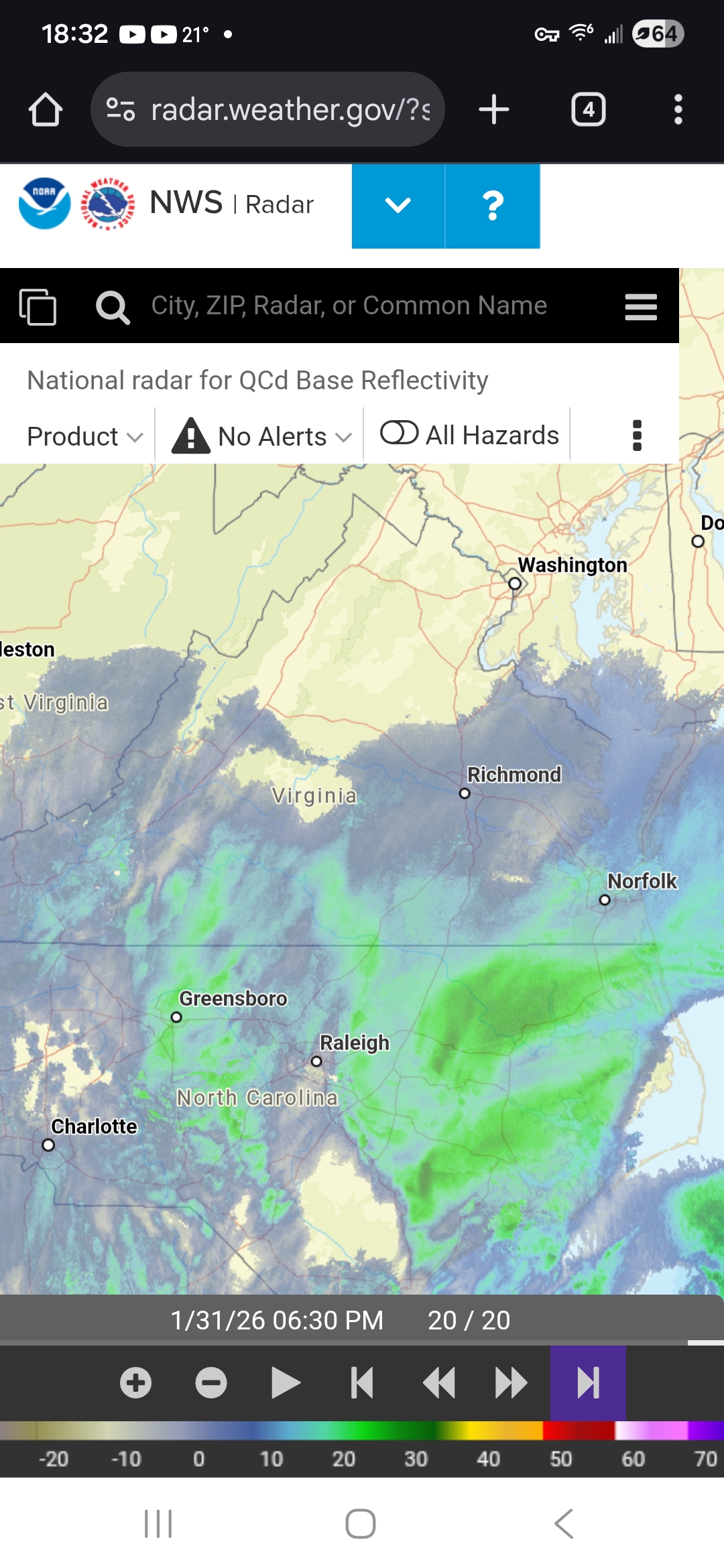
Base reflectivity light but steady. Question is do we have time to moisten things up.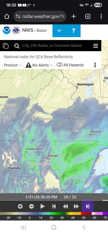
-
Richmond Metro/Hampton Roads Area Discussion
Berlin1926 replied to RIC Airport's topic in Mid Atlantic
Its up there just evaporating before getting down... -
Richmond Metro/Hampton Roads Area Discussion
Berlin1926 replied to RIC Airport's topic in Mid Atlantic
Wow! Im up in Brandermill and not even a flake! -
Richmond Metro/Hampton Roads Area Discussion
Berlin1926 replied to RIC Airport's topic in Mid Atlantic
Its definitely up there but its so dry its evaporating. We need this to continue for a few hours to hopefully squeeze out some flakes. Poor Raleigh looks dry period. -
Richmond Metro/Hampton Roads Area Discussion
Berlin1926 replied to RIC Airport's topic in Mid Atlantic
So close yet so far away.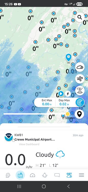
-
Richmond Metro/Hampton Roads Area Discussion
Berlin1926 replied to RIC Airport's topic in Mid Atlantic
It's 22 in Midlothian Wow. Its dry cold -
The “I bring the mojo” Jan 30-Feb 1 potential winter storm
Berlin1926 replied to lilj4425's topic in Southeastern States
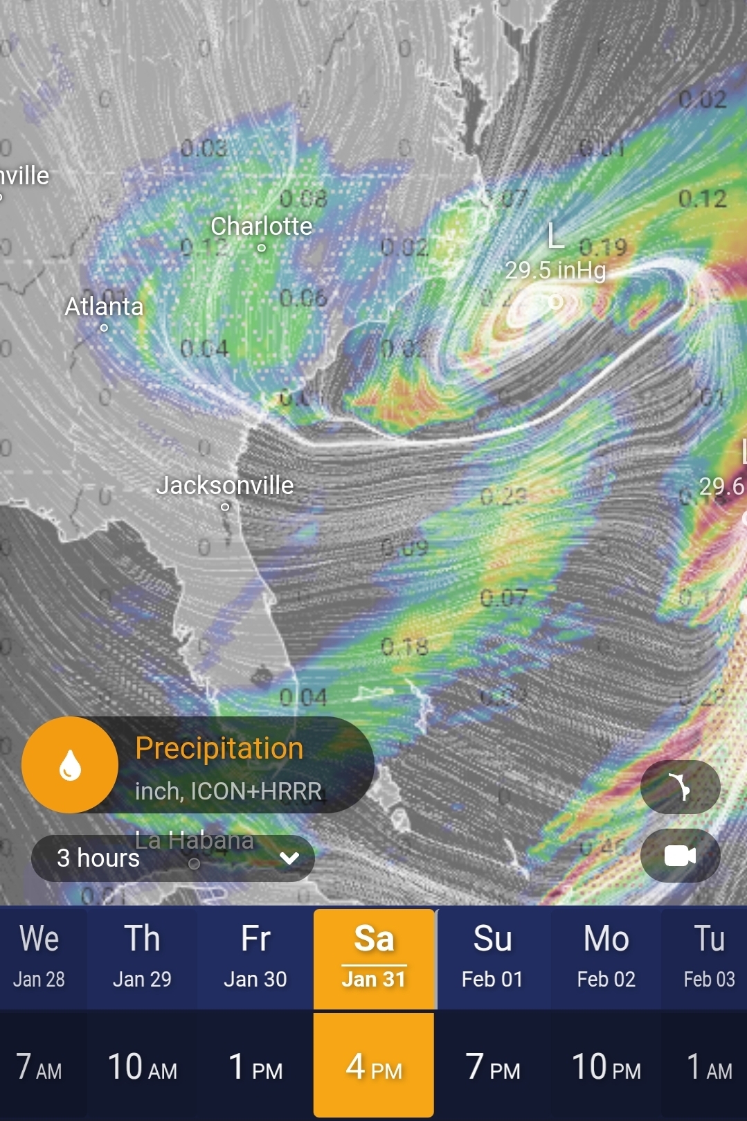
Cool tool. Here it is at 4p.
-
Richmond Metro/Hampton Roads Area Discussion
Berlin1926 replied to RIC Airport's topic in Mid Atlantic
Strangest forecasting this close to a storm I think ive ever seen in 30 years. This is bizarro world. -
Now, far north and west will it go?
-
Richmond Metro/Hampton Roads Area Discussion
Berlin1926 replied to RIC Airport's topic in Mid Atlantic
This seems very plausible.