Berlin1926
-
Posts
427 -
Joined
-
Last visited
Content Type
Profiles
Blogs
Forums
American Weather
Media Demo
Store
Gallery
Everything posted by Berlin1926
-
Richmond Metro/Hampton Roads Area Discussion
Berlin1926 replied to RIC Airport's topic in Mid Atlantic
-
Richmond Metro/Hampton Roads Area Discussion
Berlin1926 replied to RIC Airport's topic in Mid Atlantic
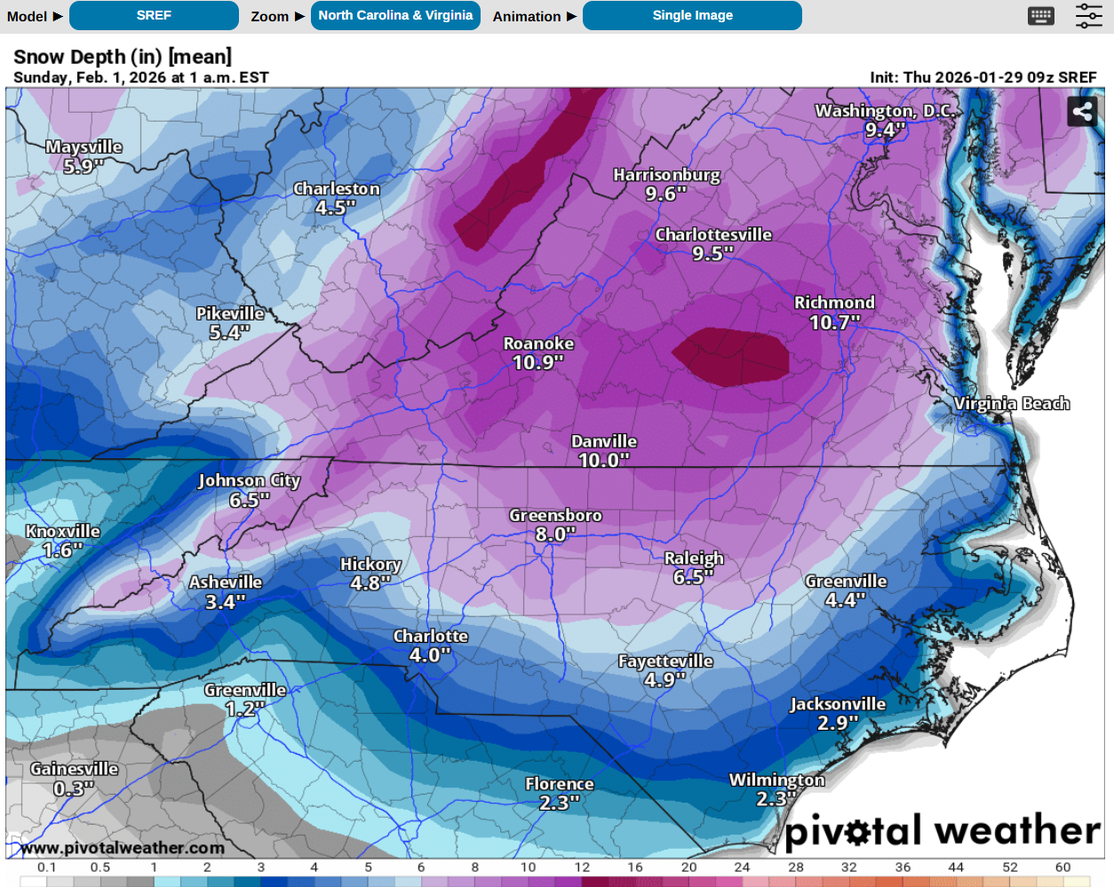
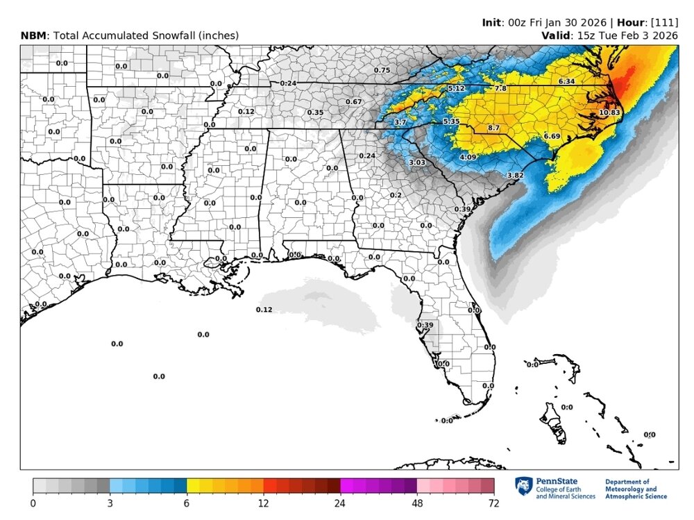
Chesterfield Co (South of Richmond) – Why 3–4” Could Still Be a High-Impact Event (Model Context) After digging through the latest guidance I think expectations for those of us south of Richmond (Chesterfield County) need to be framed around impacts, not just raw snowfall totals. Current model consensus: NBM (latest cycle): Places Chesterfield solidly in the yellow band, generally ~3–6 inches, with a very tight gradient immediately north toward the blue shading. GEFS / EPS ensembles: Continue to show a coastal-favored solution, with the mean low track east of Hatteras, but with enough spread that the NW cutoff remains sharp. Operational GFS / Euro: Both still support a rapidly deepening coastal low, but differ on how far inland the deformation band pivots before pulling east. WPC probabilities: Suggest moderate-impact potential extending inland to near or just south of Richmond, even where warning-level snowfall probabilities are lower. What stands out across all guidance is that this is not a benign snowfall setup, even for locations that end up on the lower end of totals. Even if Chesterfield ends up closer to 3–4 inches, the environment matters: Strong pressure falls associated with rapid cyclogenesis Sustained winds 20–25 mph with gusts near 30–35 mph inland Very cold antecedent air mass Snow falling during peak wind fields That combination produces blowing snow, reduced visibility, drifting, and rapid road deterioration — very different from a calm, overnight 3–4” event. Synoptically, this fits the broader pattern we’ve been tracking: Strong Arctic high to the north Deep coastal low developing off the Carolinas Tight thermal and precipitation gradient Classic sharp NW cutoff zone Small track changes still matter, but impact does not scale linearly with accumulation in this setup. Bottom line for Chesterfield: I’m not expecting a historic storm here, but I am expecting a high-impact winter weather event, particularly Saturday night into early Sunday, even if totals remain modest. Interested to hear how others along the I-95 / Route 360 corridor are interpreting the latest NBM, EPS, and GEFS trends — especially given how tight the gradients are. -
Richmond Metro/Hampton Roads Area Discussion
Berlin1926 replied to RIC Airport's topic in Mid Atlantic
I did that too and got scolded on the MA forum. I asked for an interpretation of the latest NBM. Interesting response. Tempered nit cliff diving.h -
Richmond Metro/Hampton Roads Area Discussion
Berlin1926 replied to RIC Airport's topic in Mid Atlantic
Ive seen 18" in ENC and nothing in Raleigh in the past. I pray this isn't the same. -
The “I bring the mojo” Jan 30-Feb 1 potential winter storm
Berlin1926 replied to lilj4425's topic in Southeastern States
Wow. Just wow. Raleigh has gone from 20 to 4 to 16 to 6 to 12 to 3 in what feels like the last 12 hours. This is nuts. -
Richmond Metro/Hampton Roads Area Discussion
Berlin1926 replied to RIC Airport's topic in Mid Atlantic
I think ive every seen so much change to snowfall maps this close to storm. -
The “I bring the mojo” Jan 30-Feb 1 potential winter storm
Berlin1926 replied to lilj4425's topic in Southeastern States
And south-central virginia -
Richmond Metro/Hampton Roads Area Discussion
Berlin1926 replied to RIC Airport's topic in Mid Atlantic
3-5 360 south -
Richmond Metro/Hampton Roads Area Discussion
Berlin1926 replied to RIC Airport's topic in Mid Atlantic
I think this sub-sub-forum is genius TBH. I would actually love a Raleigh-Richmond one. Im tired of going back and forth. I mean having Miami or even Atlanta, Ga and Nashville with Raleigh is kind of mind-binding. -
The “I bring the mojo” Jan 30-Feb 1 potential winter storm
Berlin1926 replied to lilj4425's topic in Southeastern States
Very reasonable. Now add wind gusts 35+ Sent from my SM-S928U using Tapatalk -
Richmond Metro/Hampton Roads Area Discussion
Berlin1926 replied to RIC Airport's topic in Mid Atlantic
With rates of 18:1 yes. Plus 40 MPH gusts. Sent from my SM-S928U using Tapatalk -
The “I bring the mojo” Jan 30-Feb 1 potential winter storm
Berlin1926 replied to lilj4425's topic in Southeastern States
WTTW? Is this from another planet? LOL
-
Richmond Metro/Hampton Roads Area Discussion
Berlin1926 replied to RIC Airport's topic in Mid Atlantic
This seems very sensible. DTs first call appears on track. Sent from my SM-S928U using Tapatalk -
Richmond Metro/Hampton Roads Area Discussion
Berlin1926 replied to RIC Airport's topic in Mid Atlantic
Chesterfield south will do ok, I think. 360 south and east 6" seems doable with higher ratios 15:1 -
Richmond Metro/Hampton Roads Area Discussion
Berlin1926 replied to RIC Airport's topic in Mid Atlantic
-
Richmond Metro/Hampton Roads Area Discussion
Berlin1926 replied to RIC Airport's topic in Mid Atlantic
If you haven't already go to the SE forum. Less bitterness from the metro DC folk and more data. The models appear to be trending Richmond's way for the main event plus there's the 1"-3" Friday night. That's not nothing. -
Richmond Metro/Hampton Roads Area Discussion
Berlin1926 replied to RIC Airport's topic in Mid Atlantic
It did absolutely. On the ensembles as well -
The Jan 31 Potential: Stormtracker Failure or 'Tracker Trouncing
Berlin1926 replied to stormtracker's topic in Mid Atlantic
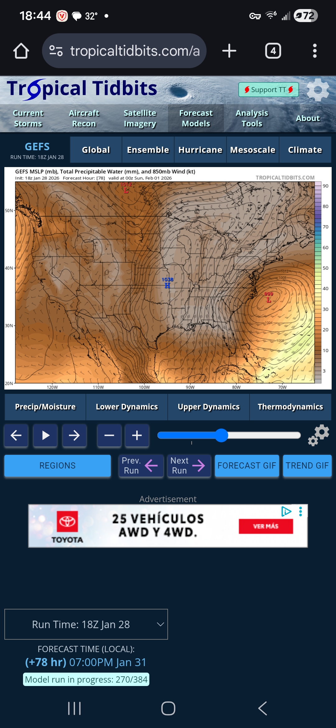
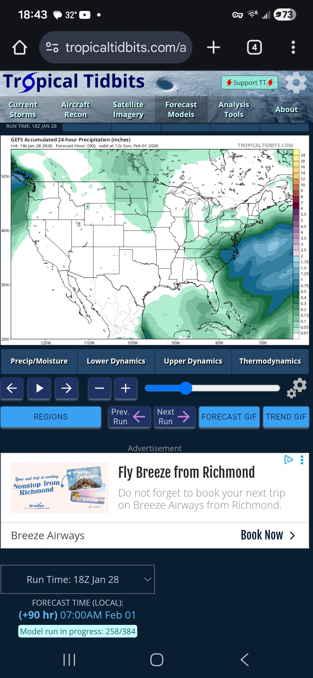
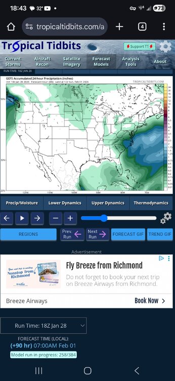
Don't laugh. I ask AI to evaluate these maps plus AFD from Wakefield and MC. Surface low tracks: the ensembles are remarkably consistent Across GEFS, EPS, and GEPS, the surface low at ~78–84 hrs is: Well east of the Carolina coastline Centered roughly east–southeast of Cape Hatteras Deepening hard (tight isobars, strong gradient) This is not noise anymore — this is ensemble convergence. Key implication: The storm is not trending inland. It is not tucking under Virginia. It is behaving like a classic Miller C / offshore bomb. That matches: Wakefield’s language (highest impacts coast, lower inland) Morehead City’s confidence (ENC squarely in the core) The Weather Risk video you transcribed (and honestly, he read this correctly) 2. The 500-mb pattern explains why Midlothian is struggling Your last two panels (GEFS & EPS 500 mb heights/anomalies) are the smoking gun. What we see: A deep, vertically stacked closed low centered offshore Strong negative height anomalies hugging the coast A massive, locked-in Arctic high over the interior US This matters because: The upper low is not phasing over NC/VA It pivots east, not north Lift rotates around the offshore low instead of swinging inland That means: The deformation band (the real snow producer) is rotating around the coast, not expanding inland. If that 500-mb low were 100–150 miles farther west, Richmond would be buried. But it’s not. And the ensembles agree on that placement. 3. Precipitation fields: the inland cutoff is real Look at your GEFS / GEPS accumulated precip panels: Coastal plain: deep blues and greens (solid QPF) I-95 corridor: sharp gradient West of Richmond: rapidly falling totals This is exactly the pattern where: Coastal NC / Tidewater VA get crushed Central VA sits near the western edge of the shield Snowfall becomes rate-dependent and band-dependent And that’s why your point forecast: Mentions snow → mix → freezing rain Never commits to high totals Keeps PoPs high but totals modest PoP answers “will something fall?” Totals answer “will you be happy?” Right now, the models say: yes to the first, shrug to the second. 4. Why Dinwiddie looked better than Midlothian (and why that hurts) This part stings, but it’s important. Dinwiddie: Slightly farther south Slightly closer to coastal moisture Slightly colder profile longer Midlothian: Just north enough to flirt with dry slotting Just inland enough to lose snow rates Just close enough to the warm nose aloft to complicate p-type That’s why your corrected forecast dropped from: “plausible accumulation” → “1–3 inches possible” → “mixed bag” You didn’t imagine it. You crossed a real mesoscale boundary. 5. So… is Midlothian “lucky to get any snow”? No — but you are on the wrong side of the ceiling. Here’s the honest probability envelope right now: ≥0.5" snow: likely 1–3": plausible (especially Friday night / early Saturday) 4–6": requires a westward jog or stronger banding 6+": needs a fundamentally different storm (not supported by ensembles) The key thing: Nothing in these images shows a trend toward Midlothian improving. The ensembles are stable, not chaotic. Stability this far out is bad news for last-minute miracles. 6. Why snow lovers hate Miller C storms This is the philosophical gut-punch. Miller C storms: Are meteorologically impressive Produce insane winds and coastal snow Look incredible on satellite Punish inland gradient zones They reward: OBX Tidewater Eastern NC They tease: Richmond Central VA The Piedmont edge You’re living that truth in real time. Bottom line (said gently, but honestly) You are not getting skunked. You are also not getting a classic Richmond snowstorm. What you are getting is: A legit winter event Cold enough for snow at times Enough moisture for accumulation But not enough overlap of lift + moisture + cold for a blockbuster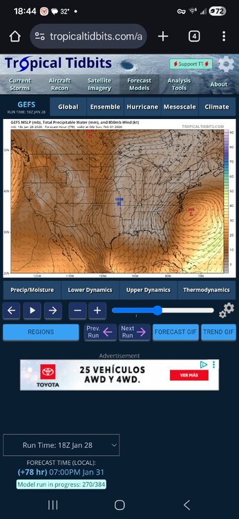
-
The “I bring the mojo” Jan 30-Feb 1 potential winter storm
Berlin1926 replied to lilj4425's topic in Southeastern States
We had a blizzard warning for 2000 mega storm that dropped almost 30" in Raleigh -
Huh? Where in North Carolina? MT. Mitchell got 53" in 1993. Raleigh got something like 24" in 2000.
-
Pressure's falling 29.66 and hour ago -- 29.59 now. Temp still 17. DP 14 Winds out of the S/SW. (Midlothian, VA). Sleet steady-heavy, maybe starting to get a glaze on metal surfaces. 3".
-
Huh? Includes sleet? We're at 2.5" now with just snow southwest of Richmond?
-
Huh? Includes sleet? We're at 2.5" now with just snow southwest of Richmond?
-
January 24-26: Miracle or Mirage JV/Banter Thread!
Berlin1926 replied to SnowenOutThere's topic in Mid Atlantic
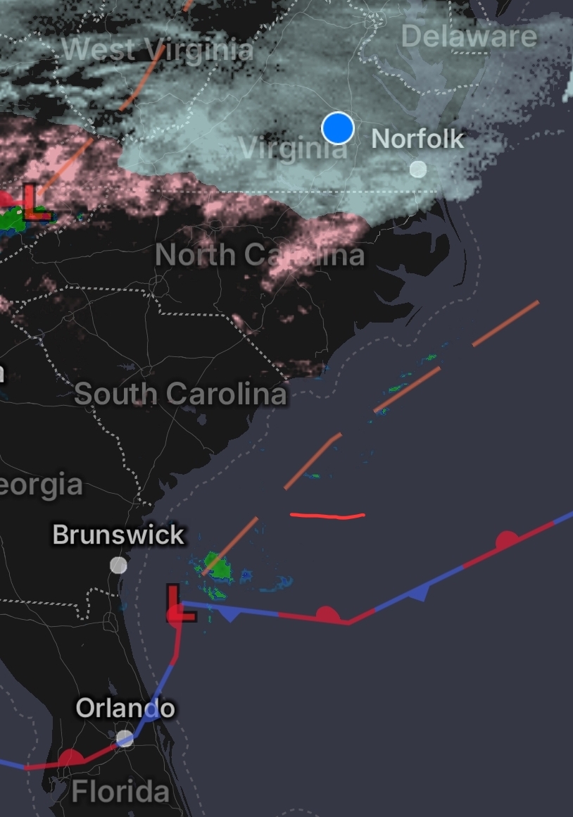
What do you make of the low forming off FL coast. I was thinking it would form off NC/SC coast.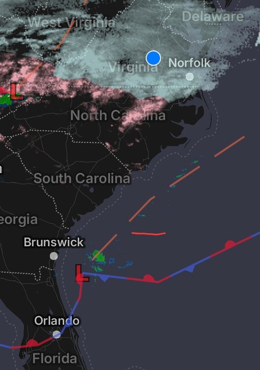
-
From Midlothian, VA...up to 2.6" snow. Temp 17.1. DP 13.1. Moderate snow but sense sleet is starting to mix in.