

JC-CT
-
Posts
18,191 -
Joined
-
Last visited
Content Type
Profiles
Blogs
Forums
American Weather
Media Demo
Store
Gallery
Everything posted by JC-CT
-
Still looks like the majority of members are shunted. Not comparing but just that run verbatim.
-
This doesn't look that good?
-
Tale of two camps on the ensembles though
-
People thought we were out? Sheesh
-
Pretty sick fronto
-
The correct answer is always
-
When do we start worrying about taint
-
How's the sampling up there?
-
Bruh just saw the gfs
-
Might make it worth it
-
Is it better, worse, or delayed until after the football game? I need to know
-
January 2016 remix lol
-
First piece should be well sampled by tomorrow?
-
Interesting
-
New England Winter 2024-25 Bantering, Whining, and Sobbing Thread
JC-CT replied to klw's topic in New England
First white christmas in what feels like a while...Merry Christmas yall -
December 2024 - Best look to an early December pattern in many a year!
JC-CT replied to FXWX's topic in New England
FedEx and UPS trucks stuck on hills galore -
December 2024 - Best look to an early December pattern in many a year!
JC-CT replied to FXWX's topic in New England
Solid squall -
Luckily doesn't seem like they are over much in the way of civilization right now
-
The best kind of crying
- 231 replies
-
- 11
-

-

-
Pretty good hit actually
-
-
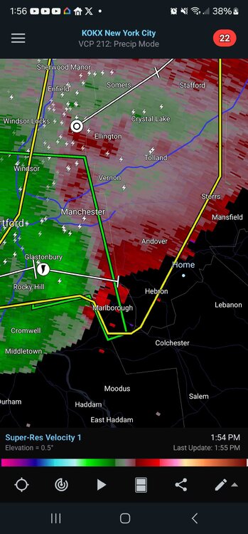
I'm not even under a warning lol
-
That's what she said
-
Just stopping in to check on the widespread, high end severe weather event for the entire region. Everything looks good?

