

Windspeed
-
Posts
4,785 -
Joined
-
Last visited
Content Type
Profiles
Blogs
Forums
American Weather
Media Demo
Store
Gallery
Everything posted by Windspeed
-
So far 2020 has been gangbusters. We're low on ACE considering number of named storms due to no majors or long-tracking storms with persistent hurricane intensity, but that is likely to change in a couple of weeks regardless of short-term development. We are still way ahead on ACE as well versus climatological mean.
-
Well if we're going to play the ~300 hr fantasy land game, why hello there upper divergent atmospheric crack on steroids...
-
This is somewhat ominous. Wind shear has been anomalously low. Sure, there has still been shear, hence Isaias' struggles and being kept in check through the Bahamas and east of Florida. Still, wasn't enough to kill it as we have seen in past seasons with early TCs. Climatological shear tends to reach its lowest point throughout the MDR and WATL by September. How anomalous lower shear heading into this period affects TCG and long-trackers remains to be seen, but it's enough to raise an eyebrow.
-
-
Both the GFS and ECMWF, including their ensembles are quiet the next 10 days for TCG across the Atlantic Basin. The Euro op does hint at MDR development next week but we appear to be entering a break in activity. Not necessarily unwarranted. July was a busy month despite no TC getting especially intense. A climatological sharp rise in activity begins around the 19th. Most signals are still strong for a very active CV stretch of the season beginning in a few weeks and likely remaining that way through October. While we still have landfall and ECONUS impacts by Isaias to deal within the next 24 hours, after everything settles, enjoy the break.
-
There's a 580 dm mid level trough / gyre extending west of the Cape Verdes. They do happen from time to time even in the EATL. But otherwise, the Azores heights have been doing their thing this year in typical fashion. Hence already having several MDR runners and strong 700 hPa wind bursts. In the first image, note the mid level trough. Also note 850 hPa vorticity field associated with TD10 riding northward and around. Regardless if TD10 gets named, it is doomed due to future encounter with marginal SSTs, but more importantly, the stable airmass about to blast off NW Africa due to, well, the Azores heights rebuilding and doing their thing again in a few days, i.e., nothing out of wack pattern-wise for any prolonged duration. Just a short-lived mid level PV trough about to get filled. See second image:
-
What, nobody's going to create a TD10 thread?!.. /s [emoji854]
-
-
This is not 93L but another wave behind it. 93L (a potential soon-to-be TC) moves NW somewhere west of the Verdes and dissipates. GFS wants to go gangbusters with the AEW behind it and grows a long-tracking deep MDR hurricane. Of note, the new GFS hasn't wanted to do jack squat with really any CV or MDR system up until now. Of course that is climatologically normal as typically this region doesn't start producing until mid August. Still...
-
Uhm... This may get classified in short order. May not do anything crazy on a forecasted NW track into marginal waters and a more stable airmass. Still pretty suggestive ASCAT:
-
The current AEW southeast of Cabo Verde has a vigorous and compact mid-level vortex. Though 92L was a larger and perhaps more impressive wave, it struggled maintaining any MCS with its mid level vort and failed to genesis before reaching a more hostile environment in the MDR. This wave on the other hand may do better entering the MDR if it can concentrate convection and close itself off at the surface. It certainly looks decent at the moment.
-
Interestingly the new AEW near the CVs has decent model support for short-term TCG.
-
-
In case anyone is curious, the next named "I" storm, Isaías, is pronounced "ee-sigh-ee-us". It's the Spanish name for Isaiah submitted by Argentina to the WMO.
-
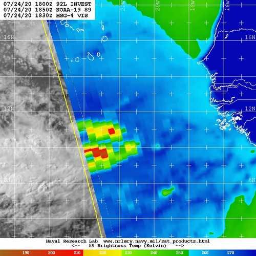
Our new Cape Verde disturbance has been designated Invest 92L.
-
This is banter'ish, but is it really? lol...
-
NHC isn't playing around with the large wave / disturbance near the Verdes. Developmental chances already up to 40%. We'll probably have a cherry tomorrow. ZCZC MIATWOAT ALL TTAA00 KNHC DDHHMM Tropical Weather Outlook NWS National Hurricane Center Miami FL 200 PM EDT Fri Jul 24 2020 For the North Atlantic...Caribbean Sea and the Gulf of Mexico: The National Hurricane Center is issuing advisories on Tropical Storm Gonzalo, located less than 500 miles east of the southern Windward Islands. The National Hurricane Center is also issuing advisories on Tropical Storm Hanna, located over the western Gulf of Mexico a little more more than 200 miles east of Corpus Christi, Texas. 1. A tropical wave located about 300 miles south-southeast of the Cabo Verde Islands continues to produced an area of cloudiness and disorganized showers and thunderstorms. The disturbance is expected move westward across the tropical Atlantic during the next several days, and some gradual development of this system is possible by early next week when it reaches the western tropical Atlantic. * Formation chance through 48 hours...low...near 0 percent. * Formation chance through 5 days...medium...40 percent. Forecaster Stewart
.jpg.4df00c6dcf87e009fec31afe00cc7978.jpg)
-
The next AEW exiting the coast already had a large wave breaking sharp axis, but now with deep convection associated with a strong MCS embedded within its inverted surface trough. This is the wave the EPS and ECMWF op runs have been consistently developing the past few days into a formidable TC. I'd say based on appearance, that's looking ever more likely. It will still have some dry air established to its north in pockets across the subtropical Atlantic, but the easterly SAL burst is way out ahead of it and may not be as much a factor. Also, the moisture envelope with this wave is quite large. If TCG occurs in the MDR this weekend into early next week, this would be Isaias. The "I" storms are frequently in the historical record as being Cape Verde or deep MDR systems east of the Antilles, but generally well into September. Here we may very well experience an "I" storm in July of 2020, yet it will not break the mold. As the Euro would have it, our next TC might end up being a powerful long-tracking Cape Verde hurricane. Obviously, not to count chickens before they hatch as even if a very advanced AEW, it's still just a low-embedded wave that could flop and not get named. Nah, who am I kidding? This thing is a beast...
-
Interesting thread on MJO phase 1 and 2 inter-seasonal as it relates to Atlantic Basin hurricane seasons. Note 2020...lol:
-
-
Invest91L has been designated. This has a decent chance of TCG in the central-to-NW GOM as conditions become more favorable. At this time there is still mid-to-upper level shear imparting over the western portion of the wave axis. But that should shift more easterly into the forecast period and allow some time for a potential low to stack. Not certain of any significant intensification but regardless, moisture fetch into very warm GOM SSTs could bring flash flooding rains into LA/Texas.
-




