

wxdude64
-
Posts
7,611 -
Joined
-
Last visited
Content Type
Profiles
Blogs
Forums
American Weather
Media Demo
Store
Gallery
Everything posted by wxdude64
-
Wow, that is like 35-40 to 1 ratios.
-
I've opened the box of pandora!
-
Awesome! Congrats and best wishes going forward.
-
Not quite as south as Roanoke, but looking back at my records, Dec 2010 was a fun month. 12.6" snow, 19 days of SOG, 13 days with a 'T', 8 days with measurable snow and only 10 days snowless. I'd take a repeat. And yes, it snowed on 24th and 25th here that year, about 3 inches total.
-
Yep. Been a while since we've had a snow fall and accumulate on everything and STAY. Usually we end up with 20-30 mph winds after and it all gets blown out/off.
-
Two edged sword. It beats down what snow you have on the ground, BUT it has a lot of staying power and is there long after the snow is gone.
-
That was a nice workout, shoveled the driveway and sidewalks out. By driveway I mean a paved 10 foot by 1400 foot area, lol. Plus, the sidewalks and stairways. Hasn't crossed freezing all day, currently 30.8/28.3 with a drizzle/snizzle thing falling since the snow stopped around 11 am.
-
I'm in-between Covington and Clifton Forge, had 5.3 at 11 am.
-
This takes slant sticking to a completely different level!
-
Did you get your wood taken care of?
-
*raises hand*
-
Looks good Bob!
-
Now WHAT would make you think other-wise??
-
OK, I called it. Sent a snow total report to NWS Blacksburg about 10 minutes ago. 1.5" on snowboard at 11 am, added to the 3.8" at 7 am, a 5.3" total. 5.0" OTG currently. STILL a few flurries and snow grains falling, but it isn't gonna add to the totals. I will say models and NWS did a good job here, forecast was 4-7". MOST models had us in 4-6" range, a couple outliners in the 6-9" range.
-
Takes that back, snow has picked up and on radar a decent batch to my west to push thru, I'll wait a bit. WAS gonna measre and send in a snow event total to NWS Blacksburg, maybe later. Eyeballing where I've cleared earlier guesstimate 1.5 has fallen since 7 am.
-
Had chicken and taters for dinner last night, so that determined this morning's late lunch/brunch. Tater cakes, bacon and toast with homemade blackberry jam. Or, as I refer to it when I make it, the biege/tan meal. Oh, this is not banter, lol. Looks like snow has lightened up a good bit in last 15, we may be done here. Still below freezing at 29.0/27.9.
-
I was kidding but appears I'm right....sadly.
-
0.3?
-
*First day in school for the little one in the future* Teacher- "So, again, explain your name 'Reekbok Snowtread' once again??"
-
Wishing you and family the best! You'll have to pick a 'snowy' type name for the baby!
-
You could have left the 'Dusting of snow' part out and still be correct.
-
Yes it is! When I did CoCoRaHS this morning at 7 am I had 3.8" on 0.36" liquid, about 10.6 to 1 ratio.
-
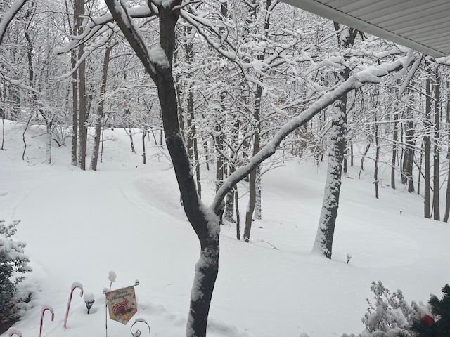
Pic from front porch about 30 minutes ago.
-
11/11 0.1 11/30 0.1 12/02 0.2 (sleet) 12/05 3.8 Total 4.2
-
Forgot the most important part, measured 4.5" when I got back.


