mitchnick
-
Posts
28,569 -
Joined
Content Type
Profiles
Blogs
Forums
American Weather
Media Demo
Store
Gallery
Everything posted by mitchnick
-
Probably the best consensus at this range all season for at least a measurable event+.
-
After Sunday, I was ready for it with a disgusted attitude. But after seeing the Gfs and Canadian, I'd love to get 1 more, then let it cook. Sun and 70'ish sounds pretty good right now.
-
This why next week is likely the end of the line. Lol
.thumb.png.aa0af52b8fa1014363c3650bac92f583.png)
-
Well, I should have mentioned that when I posted I had little doubt that it would get shoved south as we approached it.
-
Next week on the Gfs in mby is sufficient for me to forget 2 days ago and end the winter looking forward to next year's Niño.
-
I got so use to seeing Kuchera maps noticeably higher than 10:1 from all the cold, now they're back to reminding me where I live. Bleh
-
Gfs is decent. Meh, inch or 2. Looked better on surface map than snowfall map.
-
I said it after the first failed threat in December, we need all models on board if we expect to score. I should have stuck with that premise over the weekend but put my chips on the failed, overperformer modeling. Oh well, just another live and never learn in the wacky, weenie world of snowpium. As for next week, I haven't even looked at it, taking the one threat/failure at a time approach. One thing is for sure, not saying they will be right, but all modeling ends winter after next week. So if it's going to happen, next week is it.
-
Don't be so cocky!
-
Here's a link to the Cansips SSTA starting in November. Looks basinwide with a lean to the west. Not a classic Modoki imho unfortunately. But the key will be the PDO and blocking coupled with this forecast, right or wrong. Forecast will be updated this weekend. https://www.tropicaltidbits.com/analysis/models/?model=cansips®ion=global&pkg=ssta_noice&runtime=2026020100&fh=9
-
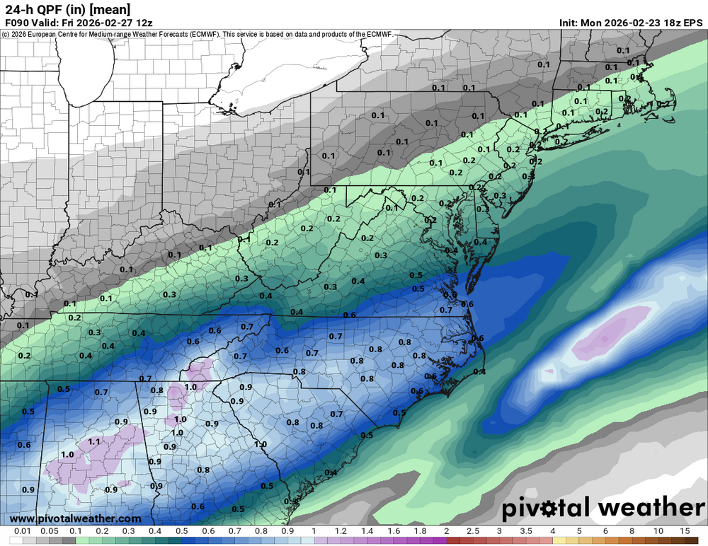
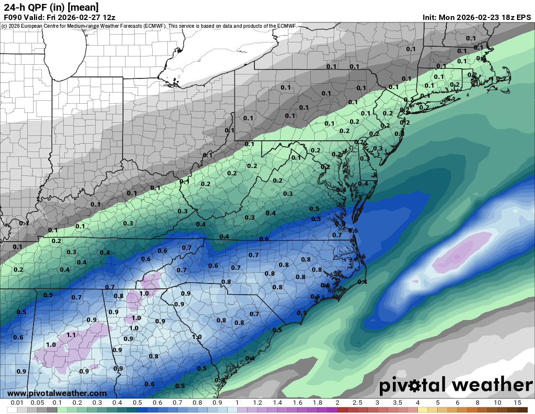
Eps 24hr qpf is south, but Eps snowfall mean is north. Qpf is low for snowfall which suggests maybe not many members are north?
.thumb.png.65d98497a27598dd1d7b7dd461d1f735.png)
-
Feb 22nd/23rd "There's no way..." Obs Thread
mitchnick replied to Maestrobjwa's topic in Mid Atlantic
Glad you're better! Did you really measure 4.25"? Eyeballing I thought 3-4". Guess I need better eyeballs. -
Feb 22nd/23rd "There's no way..." Obs Thread
mitchnick replied to Maestrobjwa's topic in Mid Atlantic
Wow. No where near that in Hanover. Eyeballing around 3-4"? Over near I83 was bullseyed by all modeling, so it makes sense. -
Feb 22nd/23rd "There's no way..." Obs Thread
mitchnick replied to Maestrobjwa's topic in Mid Atlantic
Really snowing hard in Hanover. Visibility is lowwwwww. -
Feb 22nd/23rd "There's no way..." Obs Thread
mitchnick replied to Maestrobjwa's topic in Mid Atlantic
Euro surprisingly low for the eastern shore and much of DE considering the runs the past few days imho. -
Feb 22nd/23rd "There's no way..." Obs Thread
mitchnick replied to Maestrobjwa's topic in Mid Atlantic
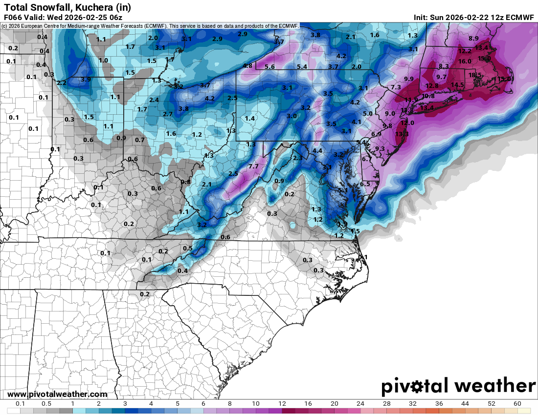
Here's Kuchera.thumb.png.c6394fdd6db4ba2ff3780857bf82e094.png)
.thumb.png.f3e7cac8673933dba8ba22ea768e0b6b.png)
-
Feb 22nd/23rd "There's no way..." Obs Thread
mitchnick replied to Maestrobjwa's topic in Mid Atlantic
18z Euro w/norlun obviously!
-
Feb 22nd/23rd "There's no way..." Obs Thread
mitchnick replied to Maestrobjwa's topic in Mid Atlantic
Ground and roofs are whitened at my daughter's 110' higher in elevation, but not mby yet. -
Feb 22nd/23rd "There's no way..." Obs Thread
mitchnick replied to Maestrobjwa's topic in Mid Atlantic
Just can't beat snow on snow piles. -
Feb 22nd/23rd "There's no way..." Obs Thread
mitchnick replied to Maestrobjwa's topic in Mid Atlantic
Same here. Wind came out of nowhere. -
Feb 22nd/23rd "There's no way..." Obs Thread
mitchnick replied to Maestrobjwa's topic in Mid Atlantic
You're not going to move again, are you? -
Feb 22nd/23rd "There's no way..." Obs Thread
mitchnick replied to Maestrobjwa's topic in Mid Atlantic
Once the heavier precip that was rotating in from the SE got over mby, it went to all snow with big flakes. -
Feb 22nd/23rd "There's no way..." Obs Thread
mitchnick replied to Maestrobjwa's topic in Mid Atlantic
My NWS forecast out of State College went down to 1-3" hours ago. Lol -
Euro wants to snow on us too.
-
Feb 22nd/23rd "There's no way..." Obs Thread
mitchnick replied to Maestrobjwa's topic in Mid Atlantic
Comparing apples to apples.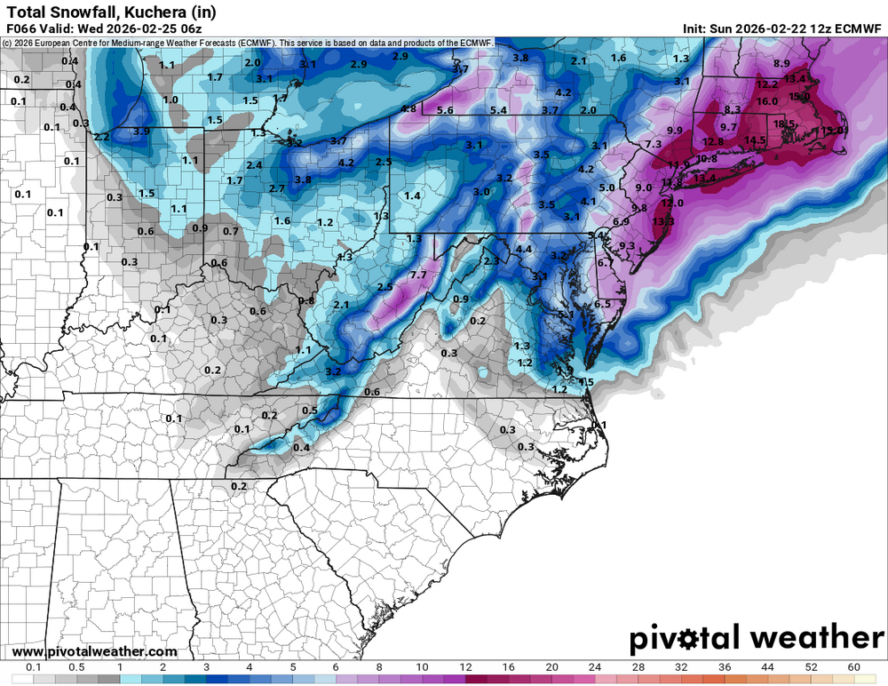


.png.9b8a7c9bb18254d6bde64cff3222b818.png)


.png.254b9c937d263d26639b7802fae87c47.png)


.png.e740325e12bd393767fb8cd62ff1aa1d.png)
.png.c8e3ce933310ed860659771194397ecf.png)