calm_days
-
Posts
284 -
Joined
-
Last visited
Content Type
Profiles
Blogs
Forums
American Weather
Media Demo
Store
Gallery
Everything posted by calm_days
-
 Yes, eventually i learned that contrails are more likely to become persistent in between weather systems and there are various interstitial areas between systems that cover a lot of area. This is part of what causes humans to say that it's chemtrails, because the likelihood of persistents has increased, and they do often look unusual and due to variations/differences in condensation nuclei for a variety of reasons, the cloud matter often has the appearance of the sun's brightness instead of stopping the progression of the sunlight. ~~ Regarding the Atmospheric Effects of Aviation Project, i do think it's important on some level, not likely exceeding this thread's existence, to consider that supersonic civilian aircraft were a real consideration back then (mid to late 1990s). Supersonic civilian transport aircraft are possibly returning at some point in the 2030s. What types of contrails and thus also cloud formations might result from their return?? As far as teleconnections, due to their higher altitude, would the effects be neutral or distinct?? It isn't something that i find to be of concern, but, it seems like it would be something that would be noticable whether it is addressed in any official press releases preceding the return of supersonic air travel. NASA Goddard was studying the climatological effects of supersonic planes' contrails at the full level of their collective knowledge back then, indicating that it would not be an insignificant potential in the future as well.
 -
2023 Atlantic Hurricane season
calm_days replied to Stormchaserchuck1's topic in Tropical Headquarters
Yes; although this image is made a lot smaller to be uploadable and downloadable quickly enough, the unique patterns are still visible!! -
LONG TERM /WEDNESDAY THROUGH SATURDAY/... Extended period is in theory more straight forward now that NHC has initiated advisories on what is expected to become tropical storm and or hurricane Idalia which I mistakenly referred to as Gert yesterday morning. Overall the system is expected to affect our area late Wednesday into Thursday. At this time threats don`t look too bad with the stronger winds mostly offshore. As for heavy rain, there could be a few hours and or bands but dry air entraining into the system from the south and west could limit this. The concern I see is that the steering currents are becoming really weak at our time of arrival of just thereafter so the remnants could wash out over or near the area. Just putting it out there. Next weekend will hopefully be dry and a bit refreshing with the airmass in the wake of the system. ^^ Earlier discussion from NWS Wilmington is wondering about whether Idalia will stall out or not
-
HRRR 12z and 18z from yesterday did depict this form of activity, although the storm strength extended more northward for the duration!! Here is the water vapor overview; there was a lot of lightning here in Brunswick county so it makes sense to see there are some big lows active to which this convection connects!!
-
The current radar though seems to show that it did not split but it looked like it was splitting. this current version of the MCS is not in the HRRR so, we will have to see what it outputs next with this information.
-
7 AM discussion update from ILM!! && .UPDATE... Appalachia is already sinking its teeth into this MCS. The typical bowing across north Georgia is occurring, with the northern segment heading more to the east, and the southern segment over metro Atlanta moving more towards the SSE. How far this thing splits gets tricky. The southern segment might sink so far south that doesn`t really touch the local forecast area. The northern segment, as it surges east, will be close. Current trends look to clip some of the northern portions of the SC Pee Dee region in a couple hours, but time will tell. The most frustrating part yet is that high-resolution guidance has backed off considerably on the convection chances and coverage today. With guidance and radar trends, tapered the rain chances off a bit for the morning, at least initially. &&
-
2023 Atlantic Hurricane season
calm_days replied to Stormchaserchuck1's topic in Tropical Headquarters
One main phenomenon which contextualizes this earlier activity is: tropical cyclones frequently meet up and merge with a larger low pressure system which is often moving from west to east. Understandably, both types of activity are here together. I think on some level there still isn't the vocabulary to describe the ULL(s) and cyclone(s) as the same system, yet, although there would be a threshhold after which it would be clear in the models that the merging would eventually happen. -
about 3 1/2 inches so far from this unique coastal low!! it's meaningful that the cooler east coast pattern has had fewer MCV inland systems and instead these occasional coastal lows which are much less disruptive in terms of wind and lightning. the heavy rain sound was relaxing but it just kept going so i did wake up and check the radar to see if it was going to conclude, which it was just about to do.
-
Area Forecast Discussion National Weather Service Wilmington NC 939 AM EDT Fri May 19 2023 .UPDATE... Heavy rain continues over the Cape Fear region, as a mesolow has set up. Both observations and radar estimates show rainfall totals of 4-6 inches over parts of Brunswick and New Hanover Counties over the last few hours. Some estimates and preliminary data even show some spots recording over 7 inches. A Flash Flood Warning has been issued for these areas until noon EDT (this will need more evaluating later). Training mesolow is nearly quasi-stationary at this point, at least another 2-3 inches of rain is possible over the next few hours. Northern extent of the surface low has started to enter the adjacent northeast SC coastal waters over the last couple of hours, seemingly kicking a little further out to the northeast than expected. This would lead you to believe that there would be a decrease in the rain, but latest analysis also shows another nearly vertically stacked low in the 925-700mb layer. This has caused some pretty deep moisture convergence/transport and frontogenesis extending roughly from 1000mb to 700mb, per the SPC Mesoanalysis page. All of this is feeding directly into the Cape Fear region from the ESE. Despite some rather speedy upshear and downshear Corfidi vectors (about 25kts), this strong, deep moisture convergence under the training mesolow means this won`t slow down over the next few hours. && New radar loop image as of just before 3 PM! && Public Information Statement National Weather Service Wilmington NC 454 PM EDT Fri May 19 2023 ...MAX 24-HR RAINFALL ACROSS SOUTHEAST NC - MAY 19 2023... Location Amount Time/Date Provider ...North Carolina... ...Brunswick County... 4 SW Belville 10.56 in 0447 PM 05/19 Mesonet 3 SSW Belville 10.31 in 0446 PM 05/19 Mesonet 1 SW Leland 8.33 in 0415 PM 05/19 Mesonet 1 N Belville 7.08 in 0415 PM 05/19 Mesonet Leland 6.75 in 0440 PM 05/19 CWOP Leland 6.67 in 0415 PM 05/19 Mesonet West End Holden Beach 3.13 in 0440 PM 05/19 CWOP Sunset Harbor (NC) 2.73 in 0440 PM 05/19 CWOP Green Swamp 2.60 in 0353 PM 05/19 RAWS Shallotte Fire Station 2.45 in 0440 PM 05/19 CWOP Bolivia 2.36 in 0437 PM 05/19 CWOP Lockwoods Folly (NC) 1.87 in 0435 PM 05/19 AWS Shallotte (South) 1.71 in 0438 PM 05/19 CWOP Shallotte 1.57 in 0440 PM 05/19 CWOP Holden Beach 0.71 in 0430 PM 05/19 CWOP ...New Hanover County... 2 ENE Belville 8.15 in 0440 PM 05/19 AWS 2 WNW Ogden 4.24 in 0415 PM 05/19 Mesonet Wilmington 4.13 in 0353 PM 05/19 ASOS Murrayville Public Works 3.37 in 0428 PM 05/19 CWOP Smith Creek 3.29 in 0415 PM 05/19 Mesonet Bayshore (NC) 1.52 in 0440 PM 05/19 AWS Masonboro 1.37 in 0440 PM 05/19 CWOP Masonboro Yacht Club 1.25 in 0345 PM 05/19 HADS ...Pender County... Surf City 3.32 in 0420 PM 05/19 Emergency Mngr Back Island 3.09 in 0418 PM 05/19 RAWS 3 SSW Hampstead 2.92 in 0415 PM 05/19 Mesonet Saltwater Landing (Surf City 2.61 in 0440 PM 05/19 CWOP &&
-
i don't have an exact answer but this overall pattern looks like one in which there are a lot of interactions between systems including some oceanic components!!
-
Some chilly periods in March and April would probably be preferable to actual heat from February through late autumn sometime!! (also i feel like if you put a vote up in Southeastern States if we were ready for a cooler than average summer, there would be lots of yes votes!!)
-
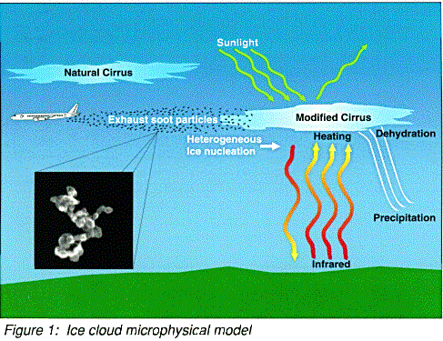
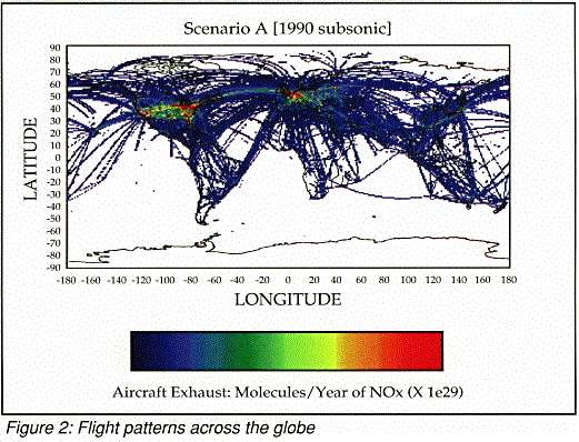
Cirrus Cloud and Climate Modifications due to Subsonic Aircraft Exhaust Key Investigators: Eric J. Jensen, Owen B. Toon NASA has recently initiated a program to evaluate the potential effects of current and future commercial aircraft fleets on atmospheric chemical processes and climate. As part of this program, we are modeling the effects of subsonic aircraft exhaust on upper tropospheric cirrus clouds. Using sophisticated computer programs, we have developed a detailed ice cloud microphysical model here at NASA Ames Research Center. The model simulates cloud processes such as ice crystal formation, growth, and transport. The formation and evolution of aircraft-generated contrails is simulated to determine what processes and environmental conditions control the growth, spreading, and dissipation of contrails. In addition, the formation of natural cirrus is simulated with and without aircraft exhaust soot particles to predict the impact of commercial air traffic on the frequency of cirrus occurrence and their impact on climate. Recent observations of cirrus clouds have shown that clear air in the upper troposphere is often supersaturated with ice. Cirrus do not always form in these regions due to the lack of natural nuclei to provide a foundation on which ice crystals form. If aircraft exhaust soot particles are efficient ice nuclei (as shown in Fig. 1) , then the frequency of cirrus may be significantly enhanced in regions with heavy air traffic (see Fig. 2) . As a result, the aircraft exhaust may increase the frequency of cirrus occurrence and increase the number of ice crystals in cirrus. As cirrus clouds absorb infrared radiation emitted by the Earth's surface and reflect sunlight, changes in cirrus properties would produce heating of the upper troposphere and cooling at the surface. Also, precipitation of cirrus ice crystals removes upper tropospheric water vapor. Because water vapor is a very important greenhouse gas, changes in cirrus and the upper tropospheric water vapor budget due to aircraft exhaust may substantially influence climate. Currently, the properties of soot generated by aircraft exhaust are not well understood. We do not know how effective these particles are as ice nuclei. We are using our cirrus cloud microphysical model to simulate the impact of soot particles on cirrus cloud frequency and climate for a wide range of assumptions about the soot properties. We are evaluating these effects for a range of environmental conditions, including cirrus anvils generated by strong convective storms and thin cirrus generated in fair-weather conditions. A final determination of the exhaust impact on cirrus and climate will require aircraft observations of natural and anthropogenic upper tropospheric particles, laboratory studies of ice nucleation on soot particles, and numerical modeling of the formation of cirrus altered by exhaust soot particles. Figure 2. Image courtesy of Steve Baughcum (Boeing Aircraft Co.), Don Maiden (Langley Research Center), and M. Metwally (McDonnell-Douglas Aircraft). i partially remembered reading this many years ago. (Although this is old information, it would be very relevant in NASA et al figuring out how to produce a new suite of information that would help people to know why clouds do what they do, including the new types of clouds and activity. I think on some level the complexity of the PR (eg. would the airlines themselves be involved?) is simply not something that NASA et al necessarily previously had the time to do. However, i think their social media teams at this point and forward, are very much able to figure it out, with some patience and problem-solving.)
-
Here is a recent study from last year!! i think this is helpful too, and i'm glad to know that many people here will be interested in reading about these phenomena. Again as professional and amateur meteorologists, we have been seeing the differences in clouds including persistent contrail clouds for some time, and have been aware the additions to the cloud atlas relating to them, and have not assigned pseudoscientific concepts to them, but were also are lacking scientific context as far as what the changes might be!! Importance of Secondary Ice Production to Ice Formation and Phase of High-Latitude Mixed-Phase Clouds during SOCRATES and MARCUS atmospheric sciences cloud physics Xi Zhao, Xiaohong Liu, Vaughan Phillips, Sachin Patade, Minghui Diao, Ching Yang, Neel Desai Abstract Measured ice number concentrations are often much higher than the number concentrations of ice nucleating particles (INPs) in moderately cold mixed-phase clouds, suggesting the potential importance of secondary ice nucleation (SIP). However, the occurrence frequency and importance of SIP relative to primary ice nucleation for ice formation and mixed-phase cloud properties are largely unknown. Representing the SIP processes in weather and climate models is equally challenging. In this study, we present a process-level understanding of SIP in high-latitude mixed-phase clouds based on integrated model-observational analyses of the NSF SOCRATES aircraft and DOE ARM MARCUS ship-borne data. We run the Community Earth System Model version 2 (CESM2) nudged towards the MERRA2 Reanalysis and output the modeled clouds and aerosols along the aircraft flight and ship tracks for direct model-observation comparisons. We found that CESM2 with a physical representation of SIP processes (e.g., ice-ice collisional break-up, droplet shattering during rain freezing) better capture the observed ice crystal number concentrations (ICNCs) and cloud properties. SIP often dominants the ice formation in the moderately cold mixed-phase clouds, and transforms ~30% of pure liquid-phase clouds simulated in the model into mixed-phase clouds. We also compare modeled ice enhancement ratio due to SIP to ICNC and INP number concentrations observed during SOCRATES and MARCUS.
-
This one is really interesting also, presented at the 1998 AEAP conference: i do not want to post every single relevant study, but, this is definitely a valid contribution to this overall topic!! A Numerical Study of Aircraft Wake Induced Ice Cloud Formation Klaus Gierens and Johan Stroms DLR, Institut Physik Atmosph D-82234 Oberpfaffenhofen, Germany Department of Meteorology, Stockholm University, S-10691 Stockholm, Sweden Aircraft condensation trails are usually thought to form mainly from condensation of ambient water vapor onto soot and other aerosol particles that originate from the fuel combustion in the jet engines (e.g. K\"archer et al.1996). However, aircraft are also able to produce large concentrations of ice crystals without involving exhaust particles. An example of such a phenomenon, termed APIP (Aircraft Produced Ice Particles; see e.g. Rangno and Hobbs, 1983; Sassen, 1991; Foster and Hallett, 1993) occurs when an aircraft moves through a super-cooled cloud. The mechanisms thought to be responsible are splintering on leading surfaces and adiabatic cooling near the aircraft and propeller tips. It is interesting to note that the mere disturbance of the air by the aircraft is able to form cloud particles. Aerodynamic cloud formation might not be restricted to temperatures warmer than -30~\Celsius, for which the APIP phenomenon has been studied so far. In the temperature range between -30 and -60~\Celsius\ which corresponds to the crusing altitudes of commercial airtraffic, the most important ice nucleation process seems to be freezing of haze droplets at relative humidities near water saturation (i.e. above ice saturation). Thus, is it possible that the turbulence alone from an aircraft flying through a metastable atmosphere, with reference to humidity, can form an APIP trail? The magnitude of the vertical air motion caused by the trailing vortices behind a big airliner can be on the order of meters per second, which results in very strong turbulence (evident to anyone who have been flying close behind an other aircraft). If an airparcel in the wake of the aircraft is lifted to the point where the humidity is increased enough for homogeneous freezing to occur, a cloud would rapidly form. To test the hypothesis: that it is possible for an aircraft to form a contrail by the aerodynamic effects from the aircraft alone, we have performed numerical simulations of ice cloud formation in the wake of an aircraft flying at cruise altitude. The engine exhaust has been excluded from the simulations in order to study cloud formation due to aerodynamic effects. The ice is formed via homogeneous freezing nucleation of ambient haze droplets in the upwelling limbs of the vortex pair behind the aircraft. Properties of wake ice clouds are compared with properties of contrails obtained with in situ measurements and recent simulations. In particular, we find that aerodynamically induced ice clouds are similar in microphysical and radiative respects to contrails that are formed from the nucleation of exhaust particles. The results show that significant fractions of contrails as young as 2 to 5 minutes may originate from aerodynamic effects and not only from nucleation of the exhaust particles. Spreading and Growth of Contrails in a Sheared Environment Eric Jensen, Andrew S. Ackerman, and Owen B. Toon The evolution of persistent contrails has modeled over time-scales of 15-180 minutes using a large-eddy simulation model with detailed microphysics. Model results have been compared to satellite and in situ measurements of persistent contrails from the SUCCESS experiment. In particular, we simulated the evolution of the persistent contrail observed on May 12, 1996. In simulations with large ambient supersaturations and moderate wind shear, crystals with lengths > 200 microns are generated within 35 minutes by depositional growth. In situ measurements in the May 12 contrail case showed that these large crystals did in fact form. The large crystals fall rapidly and the contrail horizontal extent increases due to the wind shear. Strong radiative heating (with rates up to 30 K/day) drives a local updraft and lofts the contrail core several hundred meters. The observed rate of contrail spreading and maintenance of optical depths larger than 0.1 can be explained simply by growth and precipitation of ice crystals nucleated during the initial contrail formation if the environmental humidity is high enough (relative humidity with respect to ice > 125%). This result is consistent with observed high humidities in regions where the persistent contrails formed on May 12. Also, the simulations indicate that the humidity must be high throughout a depth of at least several hundred meters below the contrail to allow the crystals to continue growing as they fall. this is from the 1999 AEAP conference!! OBSERVED CONTRAIL-CIRRUS FORMATION CONDITIONS AND IMPLICATIONS Ulrich Schumann, Deutsches Zentrum für Luft- und Raumfahrt (DLR), Institut für Physik der Atmosphäre, Oberpfaffenhofen, 82230 Wessling, Germany, email: [email protected] According to the Schmidt-Appleman criterion, contrails form below a threshold temperature or above a threshold altitude in the troposphere. The threshold temperature is engine dependent. The extended Schmidt-Appleman criterion accounts for the so-called „h -effect" where h is the overall propulsion efficiency of the engine/aircraft combination (Schumann, 1996, Meteor. Z., 5, 4-23), i.e. the fraction of combustion heat used to provide the work to propel the aircraft against its drag. For large h , the engine exhaust temperature-/humidity-excess ratio is small and mixing with ambient causes contrails at higher ambient temperature than for low h , since only the fraction (1-h ) of the heat but all of the H2O from the fuel combustion leaves the engine with the exhaust gases. The efficiency h of present engines is expected to increase with better technology in the future, and future aircraft cause contrails over a larger altitude range. Persistent contrails form in ice-supersaturated air masses. Aircraft induce cirrus in weakly ice-supersaturated air masses where no cirrus would have formed otherwise. These findings, as discussed in chapter 3 (with D. W. Fahey et al.) of the forthcoming IPCC report, are of importance in assessing the climatic impact of contrails, and caused considerable debates. This paper reviews the arguments and provides new data to support the findings. Recent contrail observations with ambient temperature and humidity measured (with J. Ovarlez) during the POLINAT 2 project provide further evidence for the importance of engine efficiency for contrail formation. The observed contrails can be explained only when the theory includes the „h -effect". Engines with high propulsion efficiency cause contrails where engines with low efficiency would cause no contrails. A spiral contrail observed in NOAA-AVHRR-satellite data of more than 1500 km length and more than 1.7 hours age provides evidence that contrails form in regions where otherwise no cirrus clouds form. Statistics of upper tropospheric humidity derived (with K. Gierens) from data obtained within the MOZAIC project (Marenco et al., 1999; Helten et al., 1999) show that airliners fly about 15% of their time in ice supersatured air masses. The ice supersaturation is often too low for natural cirrus particle nucleation. Direct intercomparison of MOZAIC and POLINAT measurements support each other (Helten et al., submitted, 1999). Ice supersaturation occurs frequently in the upper troposphere in the North Atlantic flight corridor, at least during the September/October 1997 POLINAT-2/SONEX experimental period. The MOZAIC data and the POLINAT data imply that the ice water content of contrails raises about exponentially with temperature. Hence, contrails forming at lower altitude and higher ambient temperature are optically thicker and radiatively more effective than contrails at higher altitudes. Preference for Presentation: oral Topic Area: Contrails might deserve a special session, but this paper could fit to the session „Atmospheric Observations". also from 1999, a short abstract but with some helpful context!! Perturbation of the aerosol layer by aviation-produced aerosols: A parametrization of plume processes B. Kärcher, DLR Institut für Physik der Atmosphäre, Germany S.K. Meilinger, Max-Planck-Institut für Chemie, Germany The perturbation of the sulfate surface area density (SAD) in the tropopause region and the lower stratosphere by subsonic and supersonic aircraft fleets is examined. The background aerosol surface area, the conversion of fuel sulfur into new sulfate particles in aircraft plumes, and the plume mixing with ambient air control this perturbation. The background aerosol surface area is enhanced by the addition of ultrafine aerosol particles at cruise altitudes. The study includes recent findings concerning the formation and development of these particles in aircraft plumes. Large-scale SAD enhancements become relevant for background SAD levels below about 1-10 mm2/cm3, even for moderate sulfate conversion fractions of 5%. Results from an analytic expression for the surface area changes are presented which contains the dependences on these parameters and can be employed in large-scale atmospheric models.
-
this seems partially relevant as well, adding some details and context to the above, and trying to answer my own question!! The Role of Fuel Sulfur in Controlling Aircraft Emissions of Volatile Aerosol Species B. Anderson, W. Cofer, G. Gregory, H. Wallio, D. Bagwell, and G. Nowicki NASA Langley Research Center Hampton, VA 23681 We report measurements of total and nonvolatile (at T ž 290°C) aerosol emission indices made 0.1 to 15 km downstream of the NASA Langley B757 aircraft alternately burning fuels containing ~70 and ~700 ppm sulfur. The flights were conducted as part of the NASA-sponsored Subsonic Assessment: Cloud and Contrail Effects Special Study, held in Salina, Kansas during April - May 1996. Data were obtained from aboard the NASA Wallops Flight Facility T-39 Sabreliner aircraft which had been instrumented with a suite of meteorological and trace gas/aerosol sensors, including capability for CO2 determination and coarse sizing of particles in the 4 nm to 3,000 nm size range. To obtain fuels with identical hydrocarbon matrices, the ~700 ppm sulfur fuel was created by introducing a sulfur additive to the ~70 S fuel. The resulting low and high sulfur content fuels were loaded in the B757 left and right wing tanks, respectively. Then, with the B757 fuel flow system, both engines could be fed from either wing tank or the individual engines could be fed with fuel from their respective wing tanks, thus making it possible to burn low and high sulfur fuel simultaneously. Exhaust plume measurements were recorded on two separate flights at altitudes ranging from the surface to > 13 km and under a variety of atmospheric conditions. Although nonvolatile aerosol (presumably soot) production was essentially equivalent, very distinct, engine independent differences in volatile aerosol emission indices were observed in combustion of the low and high sulfur fuels. These differences were most pronounced in the ultrafine size range (4 to 20 nm diameter particles) where a 10 to 20 times greater normalized number density of particles were observed in the high S plume. Indeed, only in contrail-producing situations were exhaust plumes from combustion of the two fuels distinguishable based on emission indices of larger particles (>20 nm). At cruise altitude and under contrail-forming conditions, we estimate, based on an inferred size distribution and assuming the particles are composed of 70:30 w/w sulfuric acid:water, that on the order of 15% and 8% of the fuel sulfur was converted to aerosols in the near-field aircraft exhaust plume in high and low sulfur fuel cases, respectively. i've not been able to find this online yet but based on the title, i do think it also would have some information relevant to this topic!! A. Ackerman Secondary Ice Nucleation in Persistent Contrails
-
I guess this could be part of it? https://web.archive.org/web/20000608111808/http://hyperion.gsfc.nasa.gov/AEAP/gandrudabs.html Contrail Microphysical Comparisons For HI/LO Sulfur During Success Bruce Gandrud, Cynthia Twohy and Darrel Baumgardner During the NASA SUCCESS campaign different levels of fuel sulfur were burned in the NASA 757. The contrails from the 757 were sampled with the suite of instrumentation on the NASA DC8. A counterflow virtual impactor (CVI) was flown with water content and condensation nuclei routinely monitored. The results clearly show higher Total Ice Conc and higher Ice Conc-Volatile nuclei in the high sulfur fuel case. These results along with Ice water content and complimentary particle measurements will be presented. Another submitted paper titled "Ice-forming Particles in Aircraft Exhaust" by Twohy and Gandrud is closely related to this work.
-
I recently saw that one type of large airliner again that produces the cumuliform contrails that we remember from when we were younger, and so i checked on wikipedia to see if there is any meteorological explanation for what determines the cloud form resulting from condensation trails. So, there is just partial information on wikipedia, but i am sure some people on here might be able to explain or accurately speculate!! A slight tangent that is also highly relevant to all of us as actual professional and amateur meteorologists: Because persistent contrails are the cause of claims of you-know-what-trails, I continue to sincerely wish that NASA would help to put an end to that conspiracy theory, which negatively impacts the mental health of potentially 100,000s of people, by revisiting the Atmospheric Effects of Aviation Project suite of information, and producing a modern "explainer" about the persistent clouds!! https://web.archive.org/web/20000520093129/http://hyperion.gsfc.nasa.gov/AEAP/AEAP.html It is definitely time to update this for the 21st century, as it is one of the more interesting NASA atmospheric science inquiries that has ever existed.
-
i don't know if there is a current thread for solar-terrestrial interactions, but this is at least interesting enough to post!! I'm not sure of the hydrometeorological significance of this specific small interaction, but that the solar cycle is getting going and could make unique changes in some upper atmospheric and whole atmospheric phenomena is interesting to note as we wonder what the upcoming winter months, and seasons to follow, will be like!! SOLAR FLARE CAUSES RARE 'MAGNETIC CROCHET': The X-flare of Jan. 9th did something rare. It jerked Earth's magnetic field. Here is a composite of magnetometer recordings from Boulder, Colorado; Honolulu, Hawaii; and Fredericksburg, Virginia: Full recordings: FRD, BOU, HON. Credit: International Real-time Magnetic Observatory Network (INTERMAGNET) The "jerk" is circled in yellow. It began around 1846 UT, and was detected by many magnetic observatories across the dayside of Earth. The phenomenon is called a 'magnetic crochet.' Radiation from the flare ionized the top of Earth's atmosphere and caused currents to flow 60 km to 100 km above Earth's surface. These currents, in turn, briefly altered Earth's magnetic field. Everything returned to normal a few minutes later.
-
2022 Mid-Atlantic Severe Wx Thread (General Discussion Etc)
calm_days replied to Kmlwx's topic in Mid Atlantic
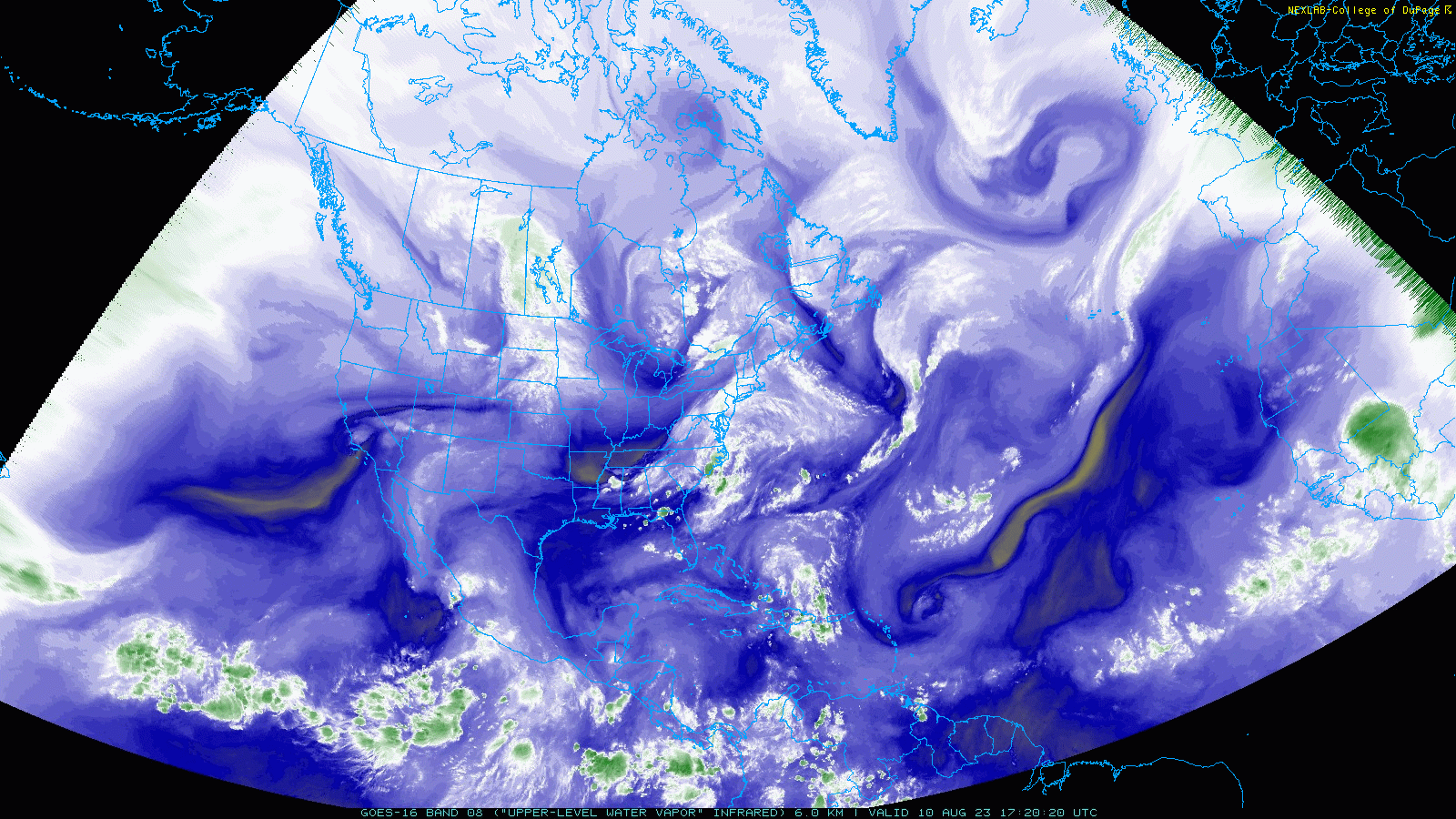
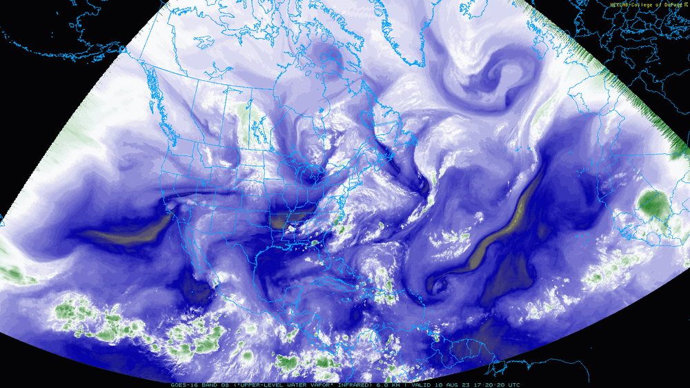
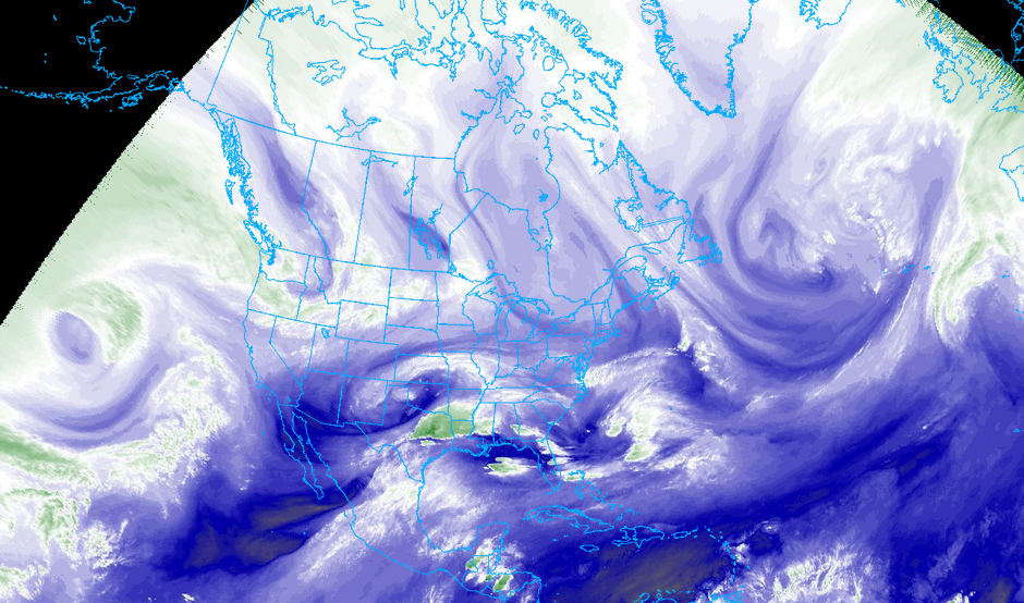
yes; Some of the aspects of the overall pattern can be seen in these water vapor images i think!! https://i.imgur.com/T4svC8I.mp4 https://i.imgur.com/2Jcm0SS.mp4 copy and paste link for fullscreen or click for a smaller view that can be expanded! -
A fairly broad Slight Risk today, but without really appearing in the HRRR. It does have mixed model support ILM: && .NEAR TERM /THROUGH TONIGHT/... Flat mid level flow through the period as low amplitude ridge stays suppressed in the Bahamas. Below 500mb however heights rise and a long trajectory from the SSW pushes 850mb to almost 20C easily allowing afternoon temperatures to soar into the mid to upper 90s, a few 100 degree readings seemingly possible. Models have backed off considerably in their depiction of early PM seabreeze convection and given the deep subcloud layer in fcst soundings this idea appears to have some merit. Later in the afternoon attention turns to the west. Convective vort max now over OK to be traversing the mountains while the sweltering heat yields 2500-3000 J/Kg of CAPE. Convection likely focused to our north (misses us completely according to the WRF) but HREF ensemble paintball output as well as the operational GFS shows pretty uniform areal coverage of storms. Damaging wind and frequent lightning appear the main threats. Severe hail also possible as the very wide CAPE in forecast soundings imply very high updraft speeds. The high LCLs and dry subcloud layer should mitigate the tornado threat. && GSP: Low amplitude troughing will remain overhead with embedded shortwaves tracking across the fcst area throughout much of the near term fcst period leading to the potential for shower and thunderstorm development. The majority of CAM guidance shows showers and thunderstorms on tap this afternoon into early this evening. However, forecast confidence will be low regarding convection as high-res guidance is not in agreement regarding where storms will initiate or the amount of coverage we will see. The HRRR has us dry the last several runs while the NAMnest shows scattered convection developing across the central NC mtns mid to late afternoon, pushing east into portions of the NC Piedmont late afternoon into early evening. The NAMnest keeps convection mainly across western NC and along the NC/SC border with most of the SC Upstate and NE GA remaining dry. The FV3, NSSL, and ARW are the most bullish with shower and thunderstorm activity this afternoon into this evening and show showers and thunderstorms initiating early afternoon across the NC mtns and pushing east while increasing in coverage across much of the CWA, with the exception of NE GA and the far western SC Upstate. With so much spread in the CAM guidance, have capped PoPs to chance across western NC and the NW SC Upstate with slight chance across NE GA and the SW SC Upstate. Shear values do not look overly impressive this afternoon, ranging from 20-30 kts. However, SBCAPE values range from roughly 1,500-2,500 J/kg this afternoon. So, with storms potentially firing during peak daytime heating, despite lower- end shear, decent instability could lead to scattered strong to severe thunderstorms this afternoon and early evening. SPC Day 1 Severe Weather Outlook currently has most of western NC and portions of the SC Upstate in a slight risk with a marginal risk from NE GA into the western SC Upstate. Main potential threats with any strong to severe storms today are damaging winds gusts and large hail. However, isolated tornadoes cannot be ruled out. RAH: This along with dew points reaching the lower-60s will support CAPE of 1500-2500 J/kg. However, it is still very unclear how much convection will be able to actually develop given the lack of upper forcing and dry NW flow aloft, with weak height rises if anything as a ridge starts to build off the Southeast US coast. CAMS had been showing the best potential for convection in the late evening and overnight hours as an MCV currently over OK/KS potentially approaches, but there has been a significant shift north with that system, with most models now showing it going through the Ohio Valley and Northeast. Thus the convective threat may be more conditional and largely dependent on either remnant outflow boundaries from the aforementioned upstream convection, or a Piedmont surface trough that will set up. Thus lowered POPs a bit keeping them in the 25-40% range. Based on the latest CAMS, any convection likely wouldn`t get going until late afternoon. Modest mid-level flow will support 0-6 km shear of 25-35 kts, which isn`t overly impressive, but could still support multicell clusters and perhaps a supercell if anything is able to develop. Hail and damaging winds would be the main hazards, as the flow looks fairly unidirectional which would limit the tornado threat. Loss of daytime heating should help diminish any convection overnight, with decreasing clouds and mild lows in the mid-60s to near 70. &&
-
There was a lot of research done in the 1990s about contrails and climate!! The main one i'm aware of is called the Atmospheric Effects of Aviation Project. https://web.archive.org/web/20000520093129/http://hyperion.gsfc.nasa.gov/AEAP/AEAP.html The correlation between increased methane, water vapor, and thus more material for contrails to persist and evolve may or may not yet have been explored directly in research, but, it does make sense. The formation of cirrus and cirruform clouds has changed quite a lot To answer LibertyBell's, i also could react negatively sometimes to the strange and unfamiliar shapes of the clouds, but lately i have a feeling that all of this possibly including the layer i've noticed may be part of an effortful attempt to manage climate feedback loops. this couldn't be announced to the public for, i am assuming here, many reasons. But, the efforts could still be made. Again i had long puzzled over the seemingly displeasing appearance of some of these types of clouds until realizing that it would be the more pure cloud types that would result in various types of runaway feedback. There is this sense that the clouds which look unattractive to us may be helping to prevent certain kinds of feedback loops, eg. that they are asymmetrical! Remember how recently we have been experiencing during tropical season what are often called "halfcanes"?? Maybe it is a key part of that. Heat domes also seem to have some relevance to this discussion but i will just mention them for now in case someone else wants to discuss them, research, and come back soon!!
-
I am glad to have a new anecdote about this phenomenon!! Yesterday i was outside and held up my finger to cover the sun, and much of the light was blocked!! Today going outside, when i block the same amount of the sun with my finger, there is still a large circular glowing area surrounding it just abou less than three times the length of the sun. In checking the water vapor satellite imagery, the amount of water vapor measured in that level of the atmosphere is much lower here today than it was yesterday. So, there is some medium in the atmosphere somewhere that the sunlight is shining through that scatters the light long before it reaches the eyes, and its extent does change from day to day.
-
Yes I would be glad to continue to edit my posts to remove anything that you consider to be too egregious!! just tell me which phrases to change! My initial instict in calling the thread "why is the sun still yellow in weather forecast graphics" wasn't correct because it did imply a change of the sun itself as opposed to an atmospheric optical phenomenon. needless to say i prefer it the way it is now! i am the opposite of a conspiritist! To this day I still wish that meteorological and aeronautical organizations acted together with a massive public information campaign to disprove the you-know-what-trail conspiracy by explaining outright that the atmospheric conditions have changed and that is why contrail dynamics visibly changed. it's possible that they were and are under pressure from industries that do not want people walking outside every day and knowing that they are seeing the direct results of climate change, but, i also find that hard to believe that NOAA, NASA, any and every science organization with purview relative to the atmosphere and weather, could have been pressured by industries that way. Without direct information from them, i consider it to be a reasonable extrapolation that the increase in and change in dynamics of persistent contrails is a result of increased atmospheric methane which also increased atmospheric water vapor. There is a reason why these clouds were not already in the atlas, they are a result of the present day atmospheric conditions! https://cloudatlas.wmo.int/en/homomutatus.html
-
After posting i saw that some explanations online were that there have been some changes in the amount of the ozone layer, which scatters the light depending on its fullness, that previously the daytime sun would have looked more yellowish to people. To address the mention of the actual sun changing, no!! I don't think that has happened, it is some sort of atmospheric variation that changes how all light passing through it will appear from below! it may relate to this phenomenon, although this study doesn't specifically mention anything about any trapped water vapor becoming a very translucent layer of clouds etc!! https://research.noaa.gov/article/ArtMID/587/ArticleID/1299/Water-vapor-in-the-upper-atmosphere-amplifies-global-warming-says-new-study National Weather Service has always had the sun's color as more of a clear white, which is reassuring, it looked like this for a long time, but then, a few days after posting the thread, i tried looking more closely at the sun and it had yellow hues in the light, more than i remembered, but still becoming a very bright and huge blob. my guess is that the sheer brightness had kept me from looking at it as directly, and that some days due to ozone variation it did appear more clear white! here is how a present-day version of the above graphic would appear, with an attempt to present the current welcome yellowishness.

-
There is a direct climate change context to this, however, we are not really sure what to call it because it was too dramatic to describe to the public (that is how it seems anyway?). To take a guess, perhaps lots of water vapor entered higher stages of the atmosphere and stayed there, changing the behavior of light passing through it. I am interested in what anyone here thinks it could be! People have been noticing this since at least 2010 if not earlier, that the daytime sun became very bright-looking, with the light splaying out in all directions, resulting in a fairly large amorphous shape in the sky, and definitely no longer had a yellow appearance (but the color as well as shape of the sun in most weather forecast graphics has stayed the same.) The phenomenon, whatever it specifically is, can always be seen during the full moon as well: a clear and wide circle of light (not a moon halo) surrounding it expands fairly far from the center and then eventually stops. It's possible that this change has happened in ancient times of hotter climates as well. it doesn't seem to be on the level of a climate disaster, but it does seem to at least resemble an effect of climate change.