rjvanals
-
Posts
715 -
Joined
Content Type
Profiles
Blogs
Forums
American Weather
Media Demo
Store
Gallery
Everything posted by rjvanals
-
We should probably avoid spiking the football before the goaline….
-

Jan 19th Snow on Snow: the this always works until it doesn't thread
rjvanals replied to psuhoffman's topic in Mid Atlantic
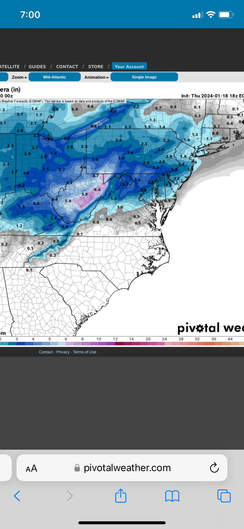
18z Euro looks like a hold vs 12z -
Jan 18-19 Storm Threat: Bob Chill made me do it
rjvanals replied to stormtracker's topic in Mid Atlantic
RGEM is better than 6z -
Jan 18-19 Storm Threat: Bob Chill made me do it
rjvanals replied to stormtracker's topic in Mid Atlantic
Yeah drier than 12z and in decent agreement w the GFS -
Mid-Atlantic Snow Totals Thread - Winter 2023-2024
rjvanals replied to mattie g's topic in Mid Atlantic
12/11 1.6” 1/16 4.8” Total: 6.4” -
Glad you got on the board after all the solid analysis you contribute
-
Jan 15-16 Storm Threat Thread: Do we finally win or get Saltburned?
rjvanals replied to H2O's topic in Mid Atlantic
Canadian would be acceptable- 425 replies
-
- 1
-

-
- jinx
- kiss of death
- (and 3 more)
-
Jan 15-16 Storm Threat Thread: Do we finally win or get Saltburned?
rjvanals replied to H2O's topic in Mid Atlantic
Kept seeing that the models kept moving the center of the low ~75 miles each run so not surprised (probably won’t help us) -
Jan Medium/Long Range Disco 2: Total Obliteration is Coming
rjvanals replied to Jebman's topic in Mid Atlantic
18z GEFS is a down tick for snow in the Monday/Tuesday period -
Looking at the MD traffic cams it doesn't look like a "real" storm until you get to Hagerstown. The Whitetail webcams look pretty awesome!
-
What’s disappointing is we had ~4 hours this morning w a good enough column but no precip ☹️
-
We’ve had some flurries off and on here but needed rates and haven’t had them
-
3K is a definite improvement by holding back the torch at 850 for a few more hours
-
That’s a depressing sight showing the lack of real January cold across the east
-
We're going to have trouble getting better trends if the low goes over Kent Island like the Euro is showing (40 mile swing from its 6z run)
-
The GFS unfortunately has picked up a stronger southerly wind at 850 across the metro the 3k NAM was showing earlier. Hope its wrong
-
The 18z Euro tries to do this at hr 54 but has a tiny warm layer just above 850 that screws it up
-
NAM would probably break DCA inch streak at least
-
Euro was the first to pick up on the mid level warmth issue on its Monday night run. The best runs for the storm showed a Saturday night into Sunday storm w a different setup vs the Saturday storm we have now so who knows if that initial scenario would’ve worked.
-
The surface has been holding pretty steady but the 850 level in particular has been degrading across the past few model cycles to a razors edge at this point
-
12z 3k NAM looks pretty similar to the 12/16/20 storm with a heavy burst of snow initially across the metro area then watched the CC line move steadily NW; wasn't a bad storm here w around 3 inches and dumped ~6 inches in Frederick https://www.washingtonpost.com/weather/2020/12/17/snow-ice-dc-md-va/
-
In that storm I went from my parents house in Potomac where we had a plowable snow to Comet Ping Pong in NW where it wasn't much more than a cartopper. 2-17-18 was another one w a sharp gradient from downtown to western suburbs as well.
-
Pretty similar idea to the GFS just juiced up a bit
-
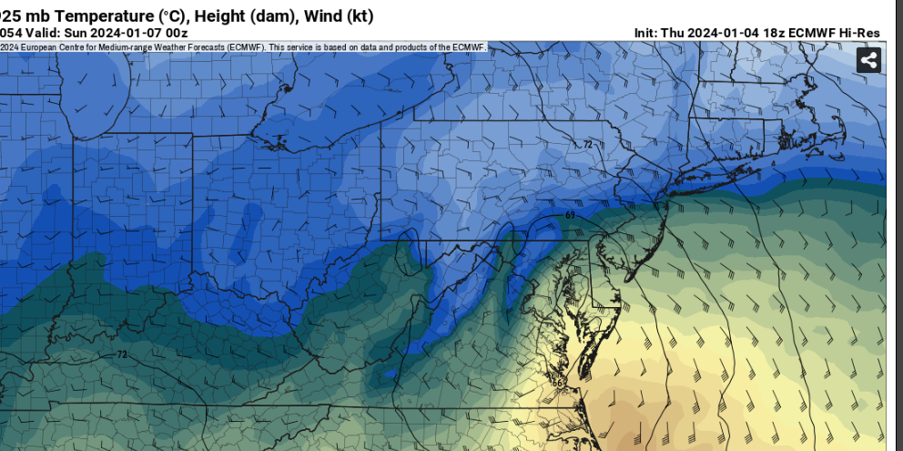
The 4pm sounding in DC that’s showing rain is borderline for snow which is the main difference between this and the past two runs