madwx
-
Posts
2,352 -
Joined
-
Last visited
Content Type
Profiles
Blogs
Forums
American Weather
Media Demo
Store
Gallery
Everything posted by madwx
-
is Baraga Plains the Peter Sinks of the UP?
-
already rocking 88/80/103 here. running a bit ahead of yesterday and the frontal boundary is hanging up about 3 counties to our north
-
Heat index hanging at 105 approaching 9PM
-
Heck yeah
-
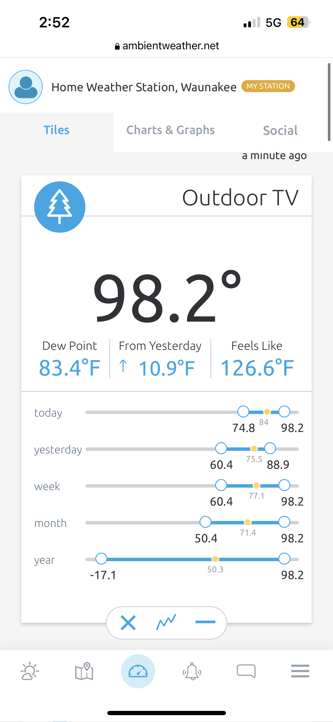
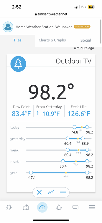
97/83/123
-
94/81/115 at my house right now
-
Only got down to 78 overnight. Today is our shot at hitting 100 IIRC the old benchmark was hitting 90 by 10 AM to be on pace for 100
-
The last Excessive Heat Watch for us was July 21-22, 2016 but that was only for 31 hours. July 17-20, 2011 we were under an EH Watch for 81 hours that was the last one longer than this. Those have been our only two in the past 15 years.
-
Finished with 3.07”. All the rain was done before noon, avoiding any major flood issues
-
up to 2.63" with heavy rain still ongoing. flood advisory put up for Dane County
-
1.25” already at my house. Flood watch seems well warranted
-

2023 Short/Medium Range Severe Weather Discussion
madwx replied to Chicago Storm's topic in Lakes/Ohio Valley
Reeling it in -
Japanese beetles are the worst, can't think of any other pest that can ruin a garden so thoroughly.
-
Estimating winds of about 60 mph here. Small branches and lots of leaves here. First crazy lightning show of the summer. Going to have about 1.4” inches when it’s all said and done. Can tell we’re coming out of the drought. Low spots in my backyard have standing water
-
out of all the MD ever written, that has to be top 10 in terms of mailing it in
-
it would become elevated over the surface inversion. if it was well formed it would still be able to punch through the cool layer and bring strong winds to the surface
-
Need some wider updrafts or some updraft merging before things really pop off
-
Initiation near Prairie Du Chien
-
Don’t love the billow clouds just to our NW but can see some nice ACCAS out my window
-
The HRRR didn't handle yesterday well at all
-
Already 81/70. Boundary sitting just to our north and better shear is moving in from the west
-
2023 Short/Medium Range Severe Weather Discussion
madwx replied to Chicago Storm's topic in Lakes/Ohio Valley
The cirrus clouds are moving off to the east. 72/67. We’ll have about 8 hours of full heating -
2023 Short/Medium Range Severe Weather Discussion
madwx replied to Chicago Storm's topic in Lakes/Ohio Valley
Feeling optimistic about tomorrow -
Did hit 91/79/107 here earlier. Mixed the dews down a bit now so heat index down to 102
-
Crazy amounts of smoke here at the surface all day today. Must be wild for all the GA planes flying VFR into EAA