
mjwise
-
Posts
477 -
Joined
-
Last visited
Content Type
Profiles
Blogs
Forums
American Weather
Media Demo
Store
Gallery
Everything posted by mjwise
-
90's in DeKalb: May - 3 June - 6 July - 2 August (assuming current forecasts hold true through the 31st) - 1 (only a 91, and we haven't had a high over 82 since that) May and June had me thinking we were in for a real steamer on par with 2012, but summer in most of this subforum just kind of rolled over after the solstice heat.
-
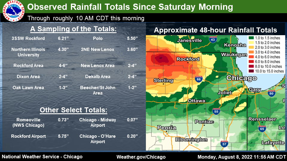
Strong E-W gradient to precipitation this month in northern Illinois. DeKalb is up to 6.48" for the month, 1.7" from this last system. Freeport is the bullseye, over a foot of rain this month. Looks like spring outside here.
-
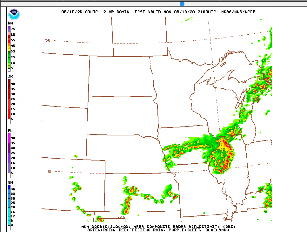
ARW/ARW2 seemed to do the best. HRDPS and RGEM in second. GGEM/CMC best of the globals. The NAM, FV3 and the rest of the globals (and their ensembles) far behind that. GFS probably in dead last - forecasting 0.1" for a city that got a foot of rain in the ensuing 36 hours. I wish the forecasting of LLJ-driven events was just a little better - they have historically produced the most severe/acute summer flood events in this part of the country and they still are just not modeled well at all. Same issue a decade+ ago. Convection is hard to model well, but the globals are still far away.
-
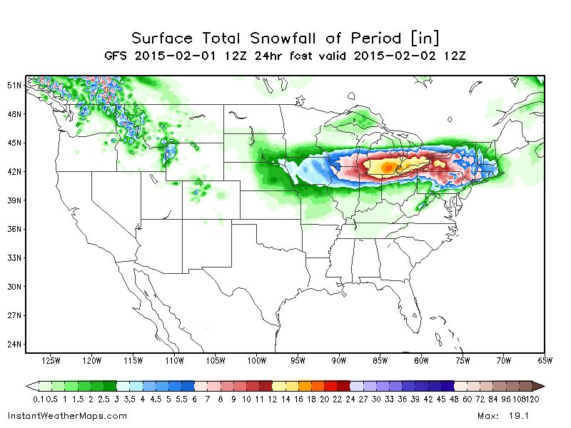
DeKalb officially ended up with 4.3" over about 30 hours from Sunday ~4AM to Monday ~10AM. Biggest rain event since I moved here a few years ago, and totals northwest were far higher. It's another under- or impoperly-modeled nocturnal LLJ event to add to a growing list this year, reminiscent of 2011. The GFS and the ECMWF were both poor, displacing the axis precipitation a hundred or more miles north just a few hours out, predicting a few tenths for locations that got nearly a foot of rain. (The mesoscale models managed it better as far as placement but still undermodeled the totals by a lot)
-
-
Dekalb ended up with more 90s in May (3) than July (2). Would not have guessed that at the beginning of July.
-
Make that 85/81.
-
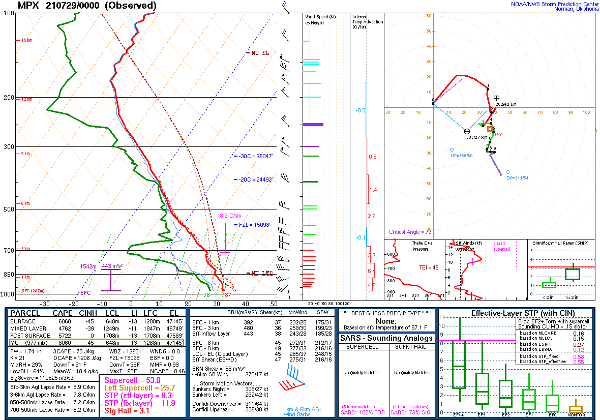
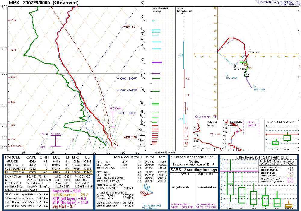
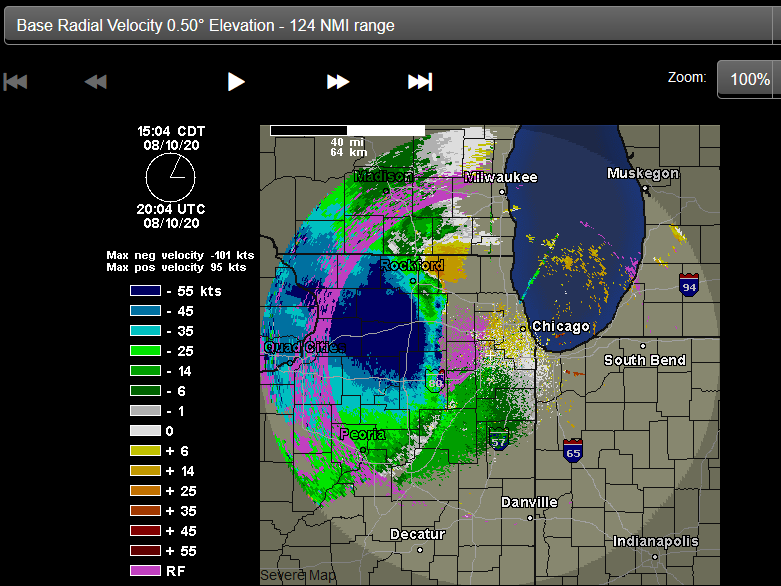
Winds maxed out in the upper 40's I think around here overnight - I slept through it. More interesting was the amount of warmth and moisture at low levels of the atmosphere. Before the line came through, KDKB achieved an 80 degree dewpoint with an 80/80 temperature reading...at 2am. There was also this sounding at MPX.
-
Everything about what is going down in the PNW is crazy. Like getting to 115 degrees in Chicago crazy. All-time record highs are going to be smashed by big margins all over the place if the models actually verify. And the scariest part of all? The GFS has led the way the whole time...
-
Just got warned. EDIT: Easily the best storm in the year I've lived here.
-
Schaumberg, hope you're cashing in on this WAA wing of storms. Nice light show down my way at least. We lucked out a week and a half ago with that small stalled cell in Dekalb - I know sycamore has seen almost nothing in June.
-
Best (Only?) T-storm of the season in DeKalb. Hadn't looked at point and click since Wednesday when there was a 0 pop and 90's forecast, so this is a pleasant surprise.
-
Not coming down as it is points east and southeast, but decent snow and 1 degree in DeKalb. -20 wind chill. Coldest I've ever experienced accumulating snow.
-
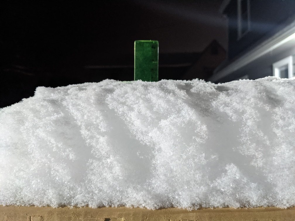
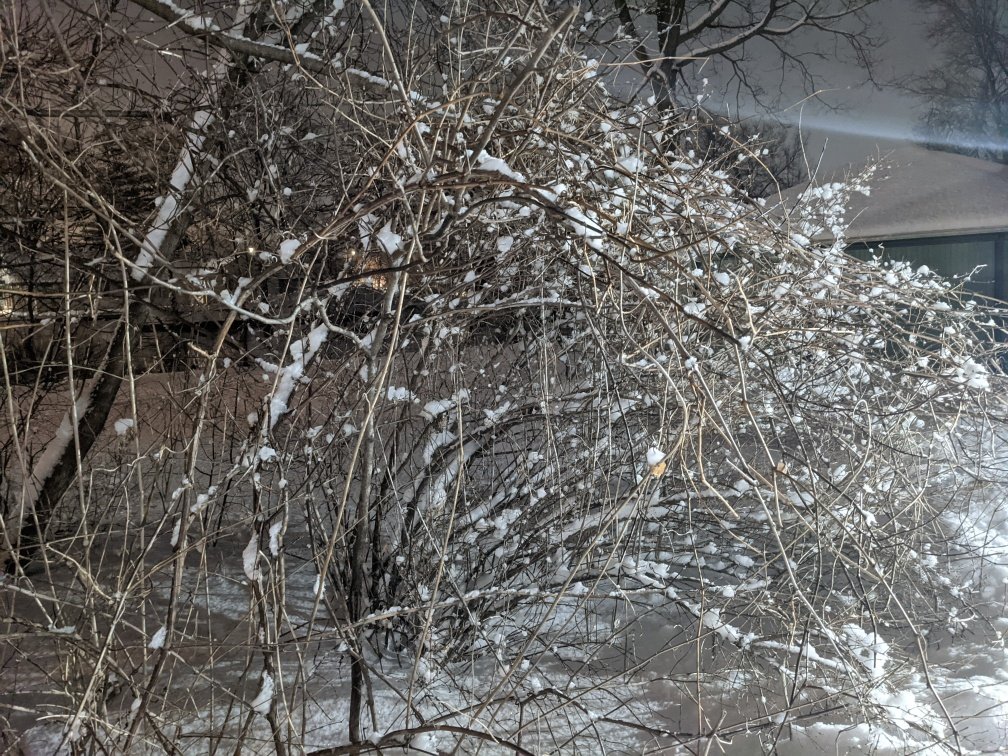
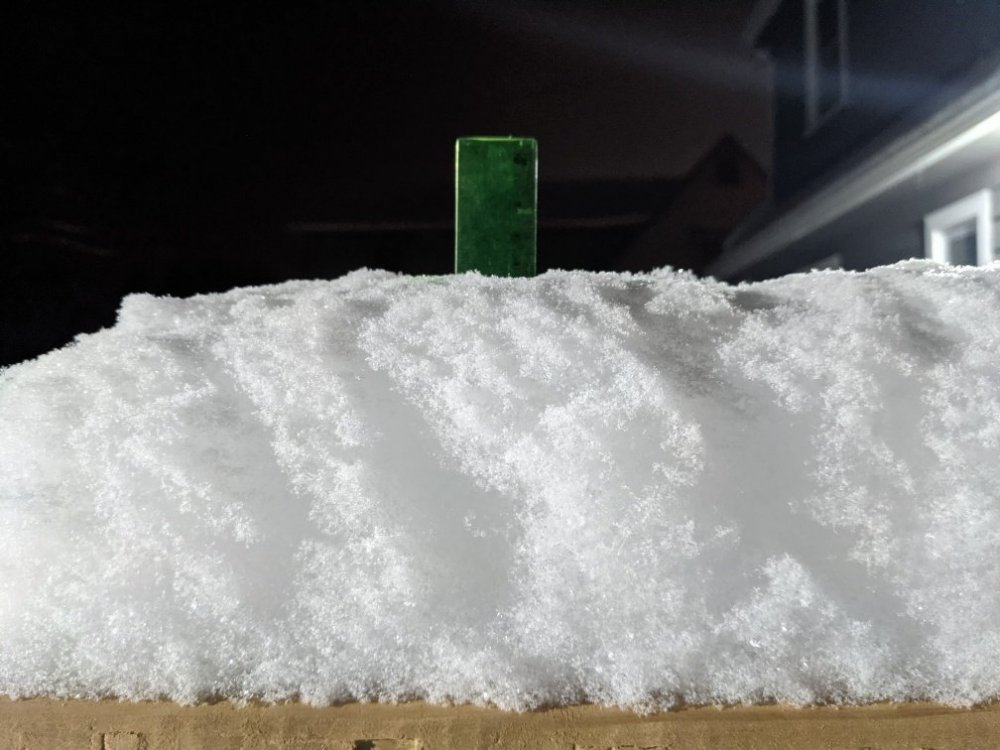
Finished with about 4" of the fluffiest snow I've ever seen in DeKalb. The ratio on this stuff has to be 25:1 or better. Weirdly enough, it kind of plastered the trees.
-
Parachutes in Dekalb at 6 degrees. I don't think I've ever seen snow at this rate at this temperature before. Only seen sugar grinders or flurries below 10 degrees.
-
Moderate snow in Dekalb. 28/17 just before it began.
-
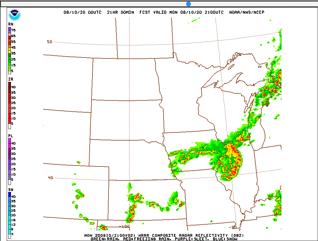
The 0z operational HRRR notches the win on this one, easily the closest of the hi res models last night. The rest missed the boat almost entirely.
-
DeKalb seriously lucked out. Windy but only leaves and small twigs down here. I am happy to take the rain and take a pass at days+ without power that people in Iowa are facing. Still ethereal and dark in the cold pool rains/gusts.
-
The wind core is south of you and not really part of the main convective line, it's a bit removed.
-
Just hit in DeKalb. Tornado sirens going off.
-
It's about go time here. FWIW, no real shelf cloud in DeKalb. Too overcast to see if there was one, at least from my house.
-
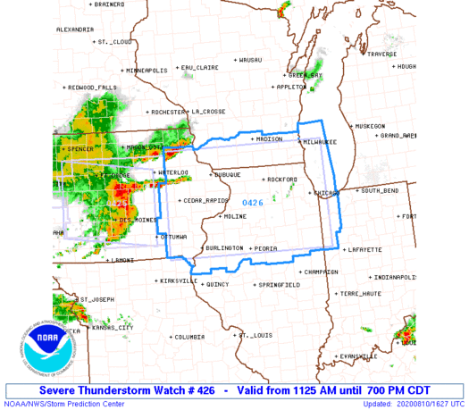
Well, 5000J/kg+ SBCAPE and 4000J/kg+ MLCAPE and 35 knots of 0-6km shear IMBY per the 19z mesoanalysis. Chances I escape with power...low and decreasing.
-
The conditions in eastern Iowa in front of this thing are about as good as it gets. The WAA wing was ready to party.
-
PDS Watch is out. 80-100 MPH gust headline.
-
If you are under 60 and do not have preexisting health conditions, you are at very low risk from the virus, even if you do contract it. If you are under age 20, we know that flu season is far more dangerous to your health. I have yet to wear a mask anywhere here in southwest Virginia. It's not being enforced or even directly suggested at any store or service provider I have visited. If I end up some place that demands wearing one, I suppose I will, but as an engineer, the idea that nonstandardized, random, contaminated pieces of cloth can appreciably prevent or stop the transmission of a tiny virus is just short of believing in magic beans. I wouldn't pile into an arena with 10,000 other people at this point, but freaking out about an unmasked person at a beach has no rational basis in the data we have.