
mjwise
-
Posts
480 -
Joined
-
Last visited
Content Type
Profiles
Blogs
Forums
American Weather
Media Demo
Store
Gallery
Everything posted by mjwise
-
We're up to 9 10 consecutive days with measurable precipitation in DeKalb. Makes it difficult to mow the lawn that sprang back to life...
-
Didn't make it close to upper 70's predicted for today. 66 seems to be the max. A dark, gray, dreary "summer is over" kind of day.
-
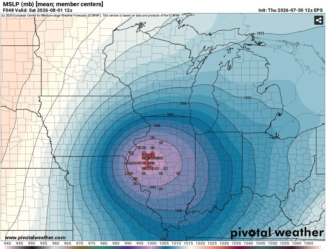
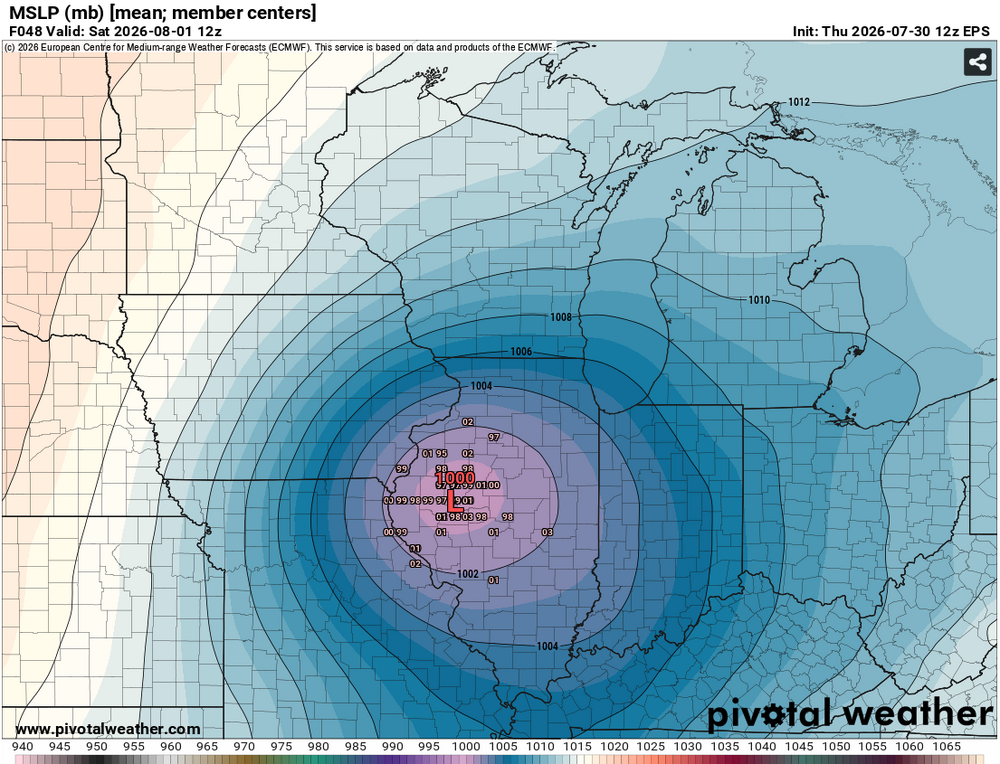
If the EPS mean pans out, it will be a record or near-record SLP for August as it is sliding across central Illinois. Record in that area is 1001-1002mb and EPS mean is hovering around that. https://www.wpc.ncep.noaa.gov/research/roth/AugustRecordLowSLPs.gif
-
Even before today's rain, this is DeKalb's first above average June for precipitation since 2018.
-
61 degrees midday with steady rain on first day of astro. summer is something I do like, but I must admit it also feels wrong. Checking Chicago-area climo for June 21-22, this kind of first day of summer happens maybe once a decade. The last four years have all had heat right around the solstice. The last year with a notably cool and rainy spell around the solstice was 2018.
-
Wind really roared here for about 10-15 minutes. 51MPH gust at recorded at DKB. Power has flickered several times. 53 degrees out. Pretty unreal for June 17, feels more like April 17. ETA: Winds still going, 49MPH gust recorded as well.
-
Our temperature has actually dipped about 5 degrees from 12:30-4:30 PM here today. Falling afternoon temps are hard to achieve without precipitation this time of the year.
-
According to this database (still seemingly updated), it would be record-breaking or nearly so for June once it gets into the lower GL region. Per the map below, record low pressure in June from Chicagoland into the central portion of the lower peninsula of michigan is ~992-993mb https://www.wpc.ncep.noaa.gov/research/roth/SLPrecords.html
-
Nice baroclinic support so far into June with the GEFS, EPS, and AIFS ensemble means all showing a 992-995mb low traversing southern Lake Michigan late Wednesday. Looks like most likely a cool rain for MBY.
-
No signs of any real summertime heat in the ensembles at least through the solstice for the GLOV.
-
Outside this forum, but Raleigh, NC is having a terrible year. They just set their (drought-assisted) 14th record high of the year down there, and their record period goes back to 1887. Ugh.
-
This was an NBM issue. The ensemble runs (both EPS and GEFS were doing it) as of Wed-Thurs last week were forecasting the development of a stout 588-591 dam ridge centered over eastern IA and western IL between Tuesday and Saturday of this week but then there were big changes across the ensembles by Saturday to a much more progressive pattern. The NBM apparently doesn't like big changes developing in the ensembles between days 5-8 and tried to "correct" what it saw as an error on its own. The extended forecast grids for our area were a mess for a couple of days because I don't think the local offices are supposed to alter the extended forecasts anymore from what NBM generates.
-
Subsevere rocking and rolling IMBY at least. Plenty of lightning and thunder though.
-
First 90 of the year for Chicago today.
-
Model sounding here for 18z is nearly 5000 SBCAPE with minimal to no capping, 87/76 T/Td, and PWAT of 2 inches. Charged! Already felt quite juicy out tonight.
-
Enhanced for severe wind also expanded into Chicagoland on the new D2.
-
Looks like it's real. Another report out of the same area at 111 MPH with debarked trees.
-
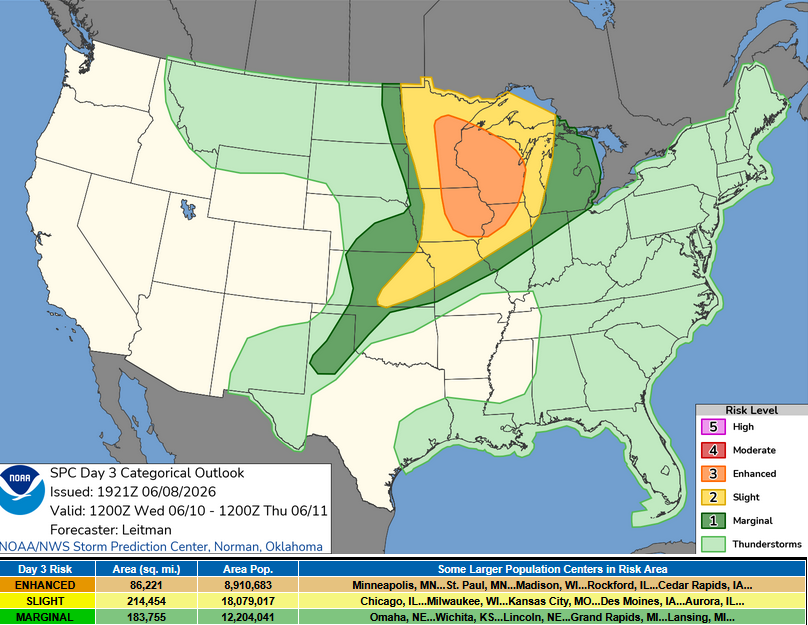
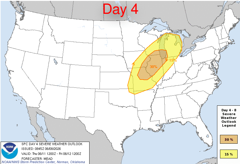
I never start threads but I thought there should be one for this with a Day 3 enhanced and Day 4 30% severe delineation already posted. Smarter people can discuss.
-
That ridge is fading fast in the models. LOT still had us well into the 90s for Thurs and Fri next week on this morning's forecast package but I think they're going to have to pull back on that. ETA: LOT noted in the morning discussion the point and click and zone forecasts are married to the NBM and that appears to be having some issues.
-
Up to about 6.8" for the month and over 11" across Mar-Apr to date. We had just 0.01" in Feb so quite an upgrade. Most of WI-IL border region is well over 10" month to date.
-
Here we got them for such a long period because DeKalb was right on the border of two different polygons separated by some time and the mixed E and NE motion of the squall line made them challenging to draw.
-
We got tornado sirens for about an hour here because of the orientation and timing of the warnings. No real wind here but great summer like squall line light show even into the cold pool.
-
A minute of slightly larger than pea-sized pingers in DeKalb at the tail end of the line.
-
88/80/105 in DeKalb. Full corn transpiration mode activated. Just disgusting.
-
I think that was the best storm we've had all year in Dekalb. Just a nice, seasonably strong afternoon storm that we didn't see at all in April or May.