
mjwise
-
Posts
477 -
Joined
-
Last visited
Content Type
Profiles
Blogs
Forums
American Weather
Media Demo
Store
Gallery
Everything posted by mjwise
-
Hello neighbor. I was going to say don't get your hopes too high - but then I see Columbia averages all of one snowy day and 1.5 inches of snow a year. I certainly hope we do better than that. This has easily been the hottest summer in SW VA in the four years I've lived here. The past few years were significantly cooler and wetter than this, especially last year - 2018 was Roanoke's wettest year on record.
-
Looks it to my untrained eye, but I'm looking more in VA and during the day on Sunday (watching soundings in BUFKIT) - not focusing on overnight in NC. ETA: Latest HRRR definitely not as warm as 3km nam was earlier. I didn't realize how warm that run was.
-
Not much forecasting left to do, and the only short range model to watch (HRRR) has been ticking warmer.
-
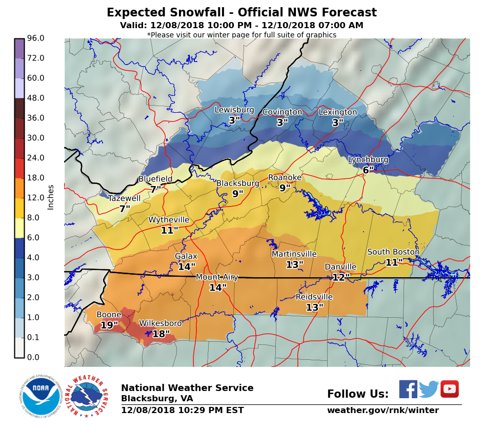
Last call from RNK

-
They made left movements, yes, but not anti-poleward. If a sustained SW movement (not a stall or eye wobble) actually occurs with this storm, it's without apparent precedent in the historical record.
-
Significant left/anti-poleward motion has never been observed with an Atlantic major hurricane at the mid latitudes in the 160+ year historical record either, so there's that too. Even getting to shore is an uncommon achievement for storms at this latitude.
-
As a reminder, the GFS is uncoupled from the ocean, meaning that a hurricane can sit and spin for an indefinite period and be fed with basically a static, inexhaustible energy source. These GFS runs showing Flo sitting in one place for like 48+ hours are immediately suspect for that reason alone.
-
I don't think the GFS models cold water upwelling or if it does it doesn't do it very well. Cat 5 comes to a complete halt just east of the OBX and maintains Cat 5 strength for over 48 hours? I don't think so.