luckyweather
-
Posts
636 -
Joined
-
Last visited
Content Type
Profiles
Blogs
Forums
American Weather
Media Demo
Store
Gallery
Everything posted by luckyweather
-
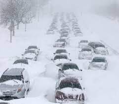
In Southern Hemisphere news, super strong PV this winter (that is of course transitioning toward summer now): The average temperature at the Amundsen-Scott South Pole Station between April and September was minus-78 degrees, coldest on record (records since 1957). 4.5 degrees lower than current 30-year average sea ice levels surrounding Antarctica hit 5th highest level on record in August Vostok Station hit -110.9 on Thursday (9/30) Southern annual mode has no meaningful connection to northern hemisphere that I know of, so no real substance here other than the bottom of the planet just had a super spicy winter. Kind of hope that isn't a foreshadowing of northern hemisphere winter as an ultra strong PV locked up tight at the pole while we have occasional cold rain and mild zonal flow all winter would suck.
-
Tabloid quality forecast, I doubt this guys has any training, but it’s September so why not? https://snowbrains.com/direct-weather-winter-early-start/ Also Judah C touches PV going into early winter in latest blog: https://www.aer.com/science-research/climate-weather/arctic-oscillation/
-
Non zero chance Monday might crank out another 90 in RFD depending on fropa timing.
-
240 hr Euro was showing strong Greenland block for around the end of the month. Optimist in me says the trend is your friend. Pessimist says we’ll blow the goods before it’s time to use them and bring out the suicide booth gif for yet another brown Christmas.
-
Normal last 90 for RFD is 8/22, latest ever was 10/9. Today was nearly certainly the last 90, finishing at 31, unless there’s an October surprise lurking beyond the extended.
-
Cells kept forming/reforming/training over nw Boone county this afternoon, second time this week that’s happened, I’ve watched the towers build nearly overhead in nw Winnebago county and then basically train over Boone / mchenry county. Certainly a coincidence but made me wonder what right here is causing the localized forcing
-
Seems like 30 is a lot, but after checking, 30 wouldn’t break the top 10 for RFD. Now 5 days past the normal last 90 (8/22). I bet we end right around 30 for RFD. https://www.weather.gov/lot/90_degrees
-

Spring/Summer 2021 Banter/Complaint Thread
luckyweather replied to madwx's topic in Lakes/Ohio Valley
17” in 24 hours, broke the old state record by 3”. Reading some of the accounts of how fast some creeks rose - unimaginable to me. One person was in a building 400’ from a creek that they said had never left its banks and within a minute was at roof level standing on things to gasp for air. -
Spring/Summer 2021 Banter/Complaint Thread
luckyweather replied to madwx's topic in Lakes/Ohio Valley
Losing 2 minutes of daylight daily here at 43 degrees north as we’ve left the solstice in our distant wake, full steam ahead to the equinox. -
I believe the president is in mchenry county right now, sitting US prez in vicinity of tor warned storm motion
-
Tor Warning for Winnebago County IL. At work in our Datacenter in Franklin Park, getting ready to head out and in that direction. Radar indicated rotation, amateur look at radar looks like the rotation is between Pecatonica and northwest of downtown Rockford, moving due east.
-
Spring/Summer 2021 Banter/Complaint Thread
luckyweather replied to madwx's topic in Lakes/Ohio Valley
A tragedy. Most of the glaciers on Rainier are about 25k years old, retreating and advancing of course, but this is just eating them up, just like the last two summers heatwaves annihilated Alaska. I don’t think we’re supposed to touch that topic too much here, but whistling past the graveyard we are. -
sweet
-
Spring/Summer 2021 Banter/Complaint Thread
luckyweather replied to madwx's topic in Lakes/Ohio Valley
I saw this in Skillings page and thought it was interesting. That fire in Rockton IL was so hot and big it was intermittently blocking the heat signature from GOES-16. https://cimss.ssec.wisc.edu/satellite-blog/images/2021/06/210614_goes16_visible_shortwaveInfrared_firePower_fireTemperature_IL_chemical_plant_fire_anim.gif -
My son had basketball practice at Hononegah high school about a half mile from the plant, they evacuated everything within 1 mile so I got this pic when picking him up around 9. Bonus pic from my house 8 miles away. Nice light rain of ash on my car in the school parking lot, top 3 precip event of the year here.
-
Spring/Summer 2021 Banter/Complaint Thread
luckyweather replied to madwx's topic in Lakes/Ohio Valley
Downhill mtb park north of MKE opened for the season today. Started out muggy and damp, rained off and on, and by the time I left around 3 it was 55 and chilly, cloud deck was basically at ground level. 80 and patchy sun a little inland, always a marvel for me what the lake can do to the weather. -
Spring/Summer 2021 Banter/Complaint Thread
luckyweather replied to madwx's topic in Lakes/Ohio Valley
Less than a month to the solstice and the sun angle starts the descent to its minima. -
My wife and I have been fully vaccinated for a few weeks now (our 2nd Pfizer dose was in mid April), never did have any detectable reaction whatsoever to the vaccine. I wear a heart rate monitoring watch (I’ve been wearing them since January 2015 and have 6 years of solid data now) and I saw a couple day marginal increase in my resting heart rate which I assume was my immune system doing what it does, and then back to my long term average. Now that Pfizer is opened up for 12 and up, our 15 year old got his first shot this morning. So far so good. Now to get it approved for under 12’s so our 11 year old can get it and we’ll be done until it’s booster time whenever that may be.
-
Pour one out for the 20/21 winter, my backyard base fully disappeared on Sunday, c’est finis. Until November....
-
marveling at the astounding departure from normal during that month and the subsequent google-ing for any insight is what led me to this board. Have never been a part of such an extreme long duration meteorological event and while I believe CC is intensifying, I doubt I’ll live through another event of that magnitude in this lifetime. This March wasn’t even remotely close. Thanks for the reminder of that amazing event.
-
PWS shows we bottomed out at 23.5 imby, also the current temp. Could be making snow right now but I’ve lost the drive, this is about as low as we saw in all of March, I had expected March to be more like recent Marches but of course, have to wait until April 1 for that.
-
Got my first dose of the Pfizer vaccine yesterday. No side effects, now to wait 3 weeks for my second dose. Very impressively efficient operation managed by the National Guard here in Winnebago County, IL. I didn’t think I’d get an appointment until into April since I’m just a regular old healthy adult but I got the email from the health department Monday and jumped on it.
-
yeah that stat / trend sucks. as a weenie you like the season to go on as long as possible but into March. April snow is useless, it’s the equivalent distance from the solstice as August, no staying power, just a total tease and annoyance. Although - caveat - the past two mid April’s quick overnight dumps have made for some spectacular morning after caked landscapes, till mid day when it’s all gone. Maybe since it’s seems March is back in the game things will equalize and April will behave a little more traditionally this year.
-
Knew we weren’t done. Euro, icon, gem, gfs all have accumulating snow to some degree in WI, N IL and IA through hour 168.
-
Laid down 3” this morning before the wet bulb got too high. Still building the base, with these 20 degree lows I can make more than the afternoon sun eats up, although I know I’m on life support here. For sheer novelty purposes I’ll keep reporting here periodically how it’s going. If every single day that conditions here supported snow it actually snowed, how long would we have snowcover? I’ll be able to tell you soon. Obviously bad science as that’s now how things work and things like surrounding snowpack albedo etc aren’t in play as this is literally only imby, but hopefully you guys find it a little interesting. Hoping to push it into April and who knows from there.


