TheWeatherPimp
-
Posts
1,400 -
Joined
-
Last visited
1 Follower

About TheWeatherPimp

- Birthday 03/14/1987
Recent Profile Visitors
15,930 profile views


-

4/1-4/2 severe threat (southern portion of subforum)
TheWeatherPimp replied to largetornado's topic in Lakes/Ohio Valley
Filtered sunshine in Indianapolis. Definitely working hard at clearing and temp up to 62 from 57. -
4/1-4/2 severe threat (southern portion of subforum)
TheWeatherPimp replied to largetornado's topic in Lakes/Ohio Valley
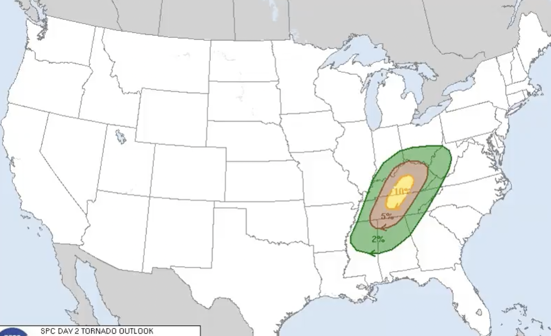
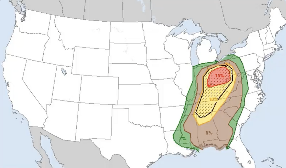
Not sure I can ever remember in the course of two day 2 outlooks, areas going from 0% tornado risk to hatched 15% tornado risk. Pretty remarkable change.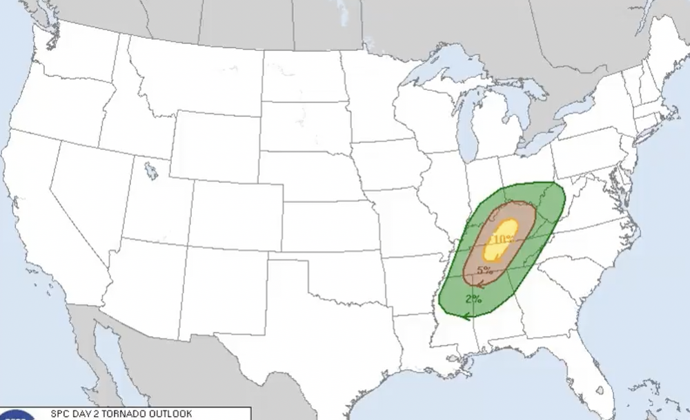
-
4/1-4/2 severe threat (southern portion of subforum)
TheWeatherPimp replied to largetornado's topic in Lakes/Ohio Valley
The SPC Day 2 outlook is......real late. I hear via chat that a Moderate Risk is coming. -
4/1-4/2 severe threat (southern portion of subforum)
TheWeatherPimp replied to largetornado's topic in Lakes/Ohio Valley
I'll be the first to admit that I woke up quite surprised to see the placement of the day 2 outlook. With the dynamics in place across much of Indiana and Western Ohio, it won't take much instability at all to cause trouble, particularly with the guidance shifting the track of the low more northwest. We'll see what their afternoon update shows, but the latest solutions are quite worrisome for much of Central and Southern Indiana and Western/Southwestern Ohio if some recovery/instability occurs tomorrow. -
2024 Short/Medium Range Severe Weather Discussion
TheWeatherPimp replied to Chicago Storm's topic in Lakes/Ohio Valley
The Winchester Tornado hit very close to home (well it was my home). The house I grew up in was destroyed and my family's houses were less than 2 blocks from the tornado. They were very lucky and I feel extremely relieved. I was on the phone with them yelling at them to get in the bathrooms and cover themselves with blankets and pillows. It was nauseating. But I'm so thankful they are all okay. It sounds like the NWS Indianapolis has finalized the rating of the Winchester tornado as an EF3. To be honest, I truly thought they might push it over the threshold based on some of the photos I've seen but I haven't seen the damage in person and won't until later this week. -
Decent freezing rain accumulations in Downtown Indy. Just now changing over to some sleet.
-
Yeah, Indy is going to be a mess during the evening commute. We should see rain change to snow in Indy/Marion County within the next 60-75 minutes and snow rates will reach 1"+ per hour for a couple hours. Hopefully people left work early.
-
NWS Indy leaning in pretty hard on their conference talking about widespread disruptions and possible power outages and structural damage due to the weight of the snow and leaning heavily into the idea that this will at least be a top 25 storm for Indy.
-
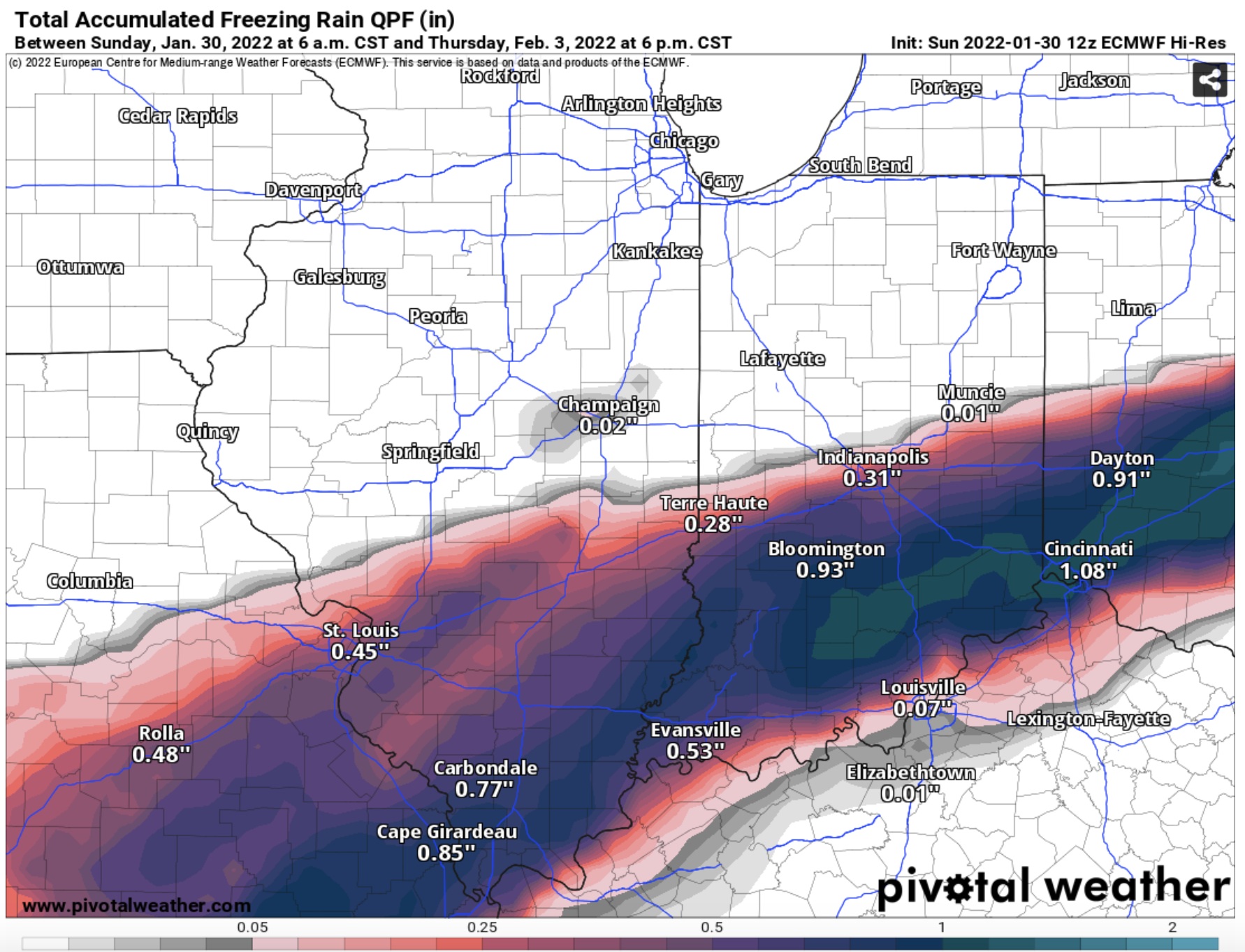
The NAM extrapolated is a classic and prolonged freezing rain event for much of Central Indiana, something I've personally been worried about for days now. This has ice event written all over it.
-
-
With the depth of the arctic air, I wouldn't be surprised to see freezing rain and temperatures in the middle to upper 20's. Ice should accrete quite efficiently wherever the band of freezing rain sets up. That combined with falling temps and strong winds Thursday Night and Friday will lead to a very dangerous combo.
-
One thing I just tweeted that I'll echo here. I'm hoping when the NWS issues headlines they keep it simple and just run a watch/eventual warning for the duration of wave 1/wave 2. No point in making things complicated when impacts will be felt from Wednesday through at least Thursday Night. But NWS IWX is already talking about possible headlines for the first wave followed by a second round of headlines for wave 2. That's overly complicated and confusing IMO. Just my two cents, not that it matters.
-
Good good sir. Moved back to Indianapolis last summer, so thought I would pop my head in here.
-
Good discussion from IND. Not sure I agree with everything they said about the freezing rain potential, but otherwise a good discussion. https://kamala.cod.edu/in/latest.fxus63.KIND.html