

Carvers Gap
-
Posts
17,456 -
Joined
-
Last visited
Content Type
Profiles
Blogs
Forums
American Weather
Media Demo
Store
Gallery
Everything posted by Carvers Gap
-

Dandridge Dollop 12/24/20 Storm Thread (Winter Wonderland)
Carvers Gap replied to AMZ8990's topic in Tennessee Valley
Side-by-side of 12z and 0z Kuchera amounts. New run is on the left. 6z was a slight improvement from 0z. 12z was a slight improvement from 6z.- 847 replies
-
- 3
-

-

-
- cold temperatures
- snow
- (and 8 more)
-
Dandridge Dollop 12/24/20 Storm Thread (Winter Wonderland)
Carvers Gap replied to AMZ8990's topic in Tennessee Valley
Kuchera from the 12z Euro has nearly identical placement of snow axis in our sub-forum but beefier. -
Dandridge Dollop 12/24/20 Storm Thread (Winter Wonderland)
Carvers Gap replied to AMZ8990's topic in Tennessee Valley
12z Euro barely budges...impressive to see back-to-back runs from 6z and 12z hold that steady after the other models moved. -
Dandridge Dollop 12/24/20 Storm Thread (Winter Wonderland)
Carvers Gap replied to AMZ8990's topic in Tennessee Valley
Through 39, looks very similar to 6z...slower than the GFS. -
Dandridge Dollop 12/24/20 Storm Thread (Winter Wonderland)
Carvers Gap replied to AMZ8990's topic in Tennessee Valley
Just looking at 500 vort maps...the 12z Euro looks very similar to its off-run at 6z through 27 -
Dandridge Dollop 12/24/20 Storm Thread (Winter Wonderland)
Carvers Gap replied to AMZ8990's topic in Tennessee Valley
12z Euro is rolling.- 847 replies
-
- 2
-
-
- cold temperatures
- snow
- (and 8 more)
-
Dandridge Dollop 12/24/20 Storm Thread (Winter Wonderland)
Carvers Gap replied to AMZ8990's topic in Tennessee Valley
Shew. There are literally all options on the table from a whiff to a major winter storm.- 847 replies
-
- 1
-
-
- cold temperatures
- snow
- (and 8 more)
-
Dandridge Dollop 12/24/20 Storm Thread (Winter Wonderland)
Carvers Gap replied to AMZ8990's topic in Tennessee Valley
12z UKMET is well east of the 12z GFS and most models. 12z CMC/GDPS is like right in the middle of the two tracks. There is a westward trend to the 12z suite for sure, but the UKMET slp is quite a bit east. This is not settled I don't think. So the eastern envelope is still a miss to the east for everyone but extreme NE TN. The western envelop is a slp slightly west of the Apps. The eastern envelop is a slop tracking just east of Asheville. UKMET looks too weak FWIW. -
Dandridge Dollop 12/24/20 Storm Thread (Winter Wonderland)
Carvers Gap replied to AMZ8990's topic in Tennessee Valley
Holding off my run until after the 12z Euro....might be interesting.- 847 replies
-
- 2
-
-
- cold temperatures
- snow
- (and 8 more)
-
Dandridge Dollop 12/24/20 Storm Thread (Winter Wonderland)
Carvers Gap replied to AMZ8990's topic in Tennessee Valley
@Holston_River_Rambler, the UKMET looks decent...but I only have it in 12 hour increments. What do you have? -
Dandridge Dollop 12/24/20 Storm Thread (Winter Wonderland)
Carvers Gap replied to AMZ8990's topic in Tennessee Valley
For folks who are new...Go to Tropical Tidbits, select the CMC from global models, choose 500 vort map from upper air dynamics tab, toggle to hour 66, and then use the previous run arrows to look at the last four runs. Look at the changes in that trough axis. GFS is similar but not nearly as pronounced.- 847 replies
-
- 1
-
-
- cold temperatures
- snow
- (and 8 more)
-
Dandridge Dollop 12/24/20 Storm Thread (Winter Wonderland)
Carvers Gap replied to AMZ8990's topic in Tennessee Valley
The buckle/indentation on the eastern side of the 500 vort trough(you can see it around MI/IN) is not nearly as pronounced on earlier runs. That same feature is on both the GFS and CMC. That is pulling the base of that trough a bit more eastward and pulling that lee side slp northwest. That feature should give us a clue on future runs. -
Dandridge Dollop 12/24/20 Storm Thread (Winter Wonderland)
Carvers Gap replied to AMZ8990's topic in Tennessee Valley
That is the sign of a pretty powerful signature for storm to do that. I simple neutral tilt trough will do the trick, and the system basically returns to that after it passes our longitude.- 847 replies
-
- 1
-
-
- cold temperatures
- snow
- (and 8 more)
-
Dandridge Dollop 12/24/20 Storm Thread (Winter Wonderland)
Carvers Gap replied to AMZ8990's topic in Tennessee Valley
12 CMC is west with its axis and on the eastern side of the envelop. The 500 vort map evolution is interesting. @Holston_River_Rambler was on to something earlier when he mentioned the axis of this trough needed to be watched. At 60, there is a portion of that trough that tightens up, goes slightly negative for a time(before returning to neutral). This pulls the slp north and west. Powerhouse of a system. That buckle(near MI/IN) on the approaching side of the trough is pulling the system west on both the CMC and GFS. That is why we are seeing slp pop in areas along the Big Sandy River.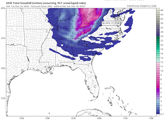
- 847 replies
-
- 2
-
-
- cold temperatures
- snow
- (and 8 more)
-
Dandridge Dollop 12/24/20 Storm Thread (Winter Wonderland)
Carvers Gap replied to AMZ8990's topic in Tennessee Valley
But man, the CMC just went freakin' bonkers. -
Dandridge Dollop 12/24/20 Storm Thread (Winter Wonderland)
Carvers Gap replied to AMZ8990's topic in Tennessee Valley
Welcome to the forum!!! -
Dandridge Dollop 12/24/20 Storm Thread (Winter Wonderland)
Carvers Gap replied to AMZ8990's topic in Tennessee Valley
12z GEFS at 54 Ioses the lee side low cluster. Looks like the slp may run west of the Apps or the energy to our north is being modeled stronger. My guess is the spine of the Apps is washing out the solution. Again, one more trend and this is a middle TN storm. Just depends on when the trend stops, but it has been pronounced for about four runs. Storm has sharpened which means it is less positive tilt and more neutral by the time it hits middle/east TN. 12z is on the left and 6z on the right...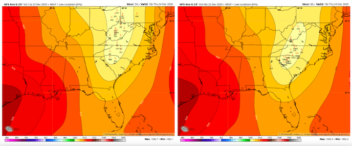
- 847 replies
-
- 1
-
-
- cold temperatures
- snow
- (and 8 more)
-
Dandridge Dollop 12/24/20 Storm Thread (Winter Wonderland)
Carvers Gap replied to AMZ8990's topic in Tennessee Valley
The trend on the GFS has taken the snow axis from central PA to eastern OH(during the past four runs: edit). Big changes and all westward at this point. I suspect the westward job stops during the next 1-2 runs if this follows the pattern of every other storm this winter. 48-96 hours have had big jogs westward and then revert back eastward at some point. Storm still looks health, but the angle of the storm is up for grabs right now.- 847 replies
-
- 2
-
-
- cold temperatures
- snow
- (and 8 more)
-
Dandridge Dollop 12/24/20 Storm Thread (Winter Wonderland)
Carvers Gap replied to AMZ8990's topic in Tennessee Valley
Surface accumulations are significantly down on this run. The westward trend continued. I think the spine of the Apps shredded the storm. I will say...one more jog westward, and this becomes a middle TN storm (and maybe major) on the GFS. The synoptics still look good, but a low directly over the apps just messes with dynamics to no end. My expectations are low for MBY on this one. -
Dandridge Dollop 12/24/20 Storm Thread (Winter Wonderland)
Carvers Gap replied to AMZ8990's topic in Tennessee Valley
GFS is going to be a paste job for some. -
Dandridge Dollop 12/24/20 Storm Thread (Winter Wonderland)
Carvers Gap replied to AMZ8990's topic in Tennessee Valley
Through 42 hours, the GFS looks sharper and follows the trend of short range modeling. -
Dandridge Dollop 12/24/20 Storm Thread (Winter Wonderland)
Carvers Gap replied to AMZ8990's topic in Tennessee Valley
12z GFS is rolling. -
December 2020 Medium/Long Term Pattern Discussion.
Carvers Gap replied to John1122's topic in Tennessee Valley
That is a nasty looking storm on the Euro after 200. -
Dandridge Dollop 12/24/20 Storm Thread (Winter Wonderland)
Carvers Gap replied to AMZ8990's topic in Tennessee Valley
12z RGEM has a similar trend NW. In this scenario, NE TN gets a good thump, but if you look at the snow totals for this storm, you can seen the axis really sharpen and back west a bit. So looks like the short range "cone" is the spine of the Apps to just around Nashville. Prior, this had stopped at the Plateau. NE TN is on the easter envelope of this now - but a good run nonetheless but trends do matter at this stage - not a huge fan of trends right now for MBY. That said, the storm is still there...just backing west a bit. So, the likelihood of somebody getting snow on Christmas Eve is still there with chances for somebody in our forum area(to see a decent thump of snow) increasing at this point.- 847 replies
-
- 4
-
-
- cold temperatures
- snow
- (and 8 more)
-
Dandridge Dollop 12/24/20 Storm Thread (Winter Wonderland)
Carvers Gap replied to AMZ8990's topic in Tennessee Valley
@John1122 and some other posters in that region are gurus for your micro-climate. I will let them answer your question in detail on that. They are way more knowledgeable about the northern Plateau than I am. But yeah, generally, your chances look decent IMHO.