WVsnowlover
-
Posts
690 -
Joined
-
Last visited
Content Type
Profiles
Blogs
Forums
American Weather
Media Demo
Store
Gallery
Everything posted by WVsnowlover
-
Outta gas and Outta Time: Early March Winter Storm finale
WVsnowlover replied to Ji's topic in Mid Atlantic
Pretty good glaze on everything here. Vehicles completely encased and fairly thick. -
Outta gas and Outta Time: Early March Winter Storm finale
WVsnowlover replied to Ji's topic in Mid Atlantic
Second biggest snow of the season here. Eyeballing around 2". Just got back from running into Charles Town which is only a few miles away and there was just a light coating. -
Outta gas and Outta Time: Early March Winter Storm finale
WVsnowlover replied to Ji's topic in Mid Atlantic
You would most definitely win the award for most negative person on this board lol. -
Feb 22nd/23rd "There's no way..." Obs Thread
WVsnowlover replied to Maestrobjwa's topic in Mid Atlantic
What model shows that at this point? At least or this way. HRRR says we're basically done out this way but sure hope it's wrong. -
Feb 22nd/23rd "There's no way..." Obs Thread
WVsnowlover replied to Maestrobjwa's topic in Mid Atlantic
Well that was fun for a little while but looks like that's about a wrap here. Have fun everyone to the east! -
Feb 22nd/23rd "There's no way..." Obs Thread
WVsnowlover replied to Maestrobjwa's topic in Mid Atlantic
Lowest visibility of the day now with small wind whipped flakes. Almost feels like an actual snowstorm out there right now. Starting to cover paved surfaces now. -
Feb 22nd/23rd "There's no way..." Obs Thread
WVsnowlover replied to Maestrobjwa's topic in Mid Atlantic
Best rates of the day. Absolutely dumping big fat flakes. Major radar enhancement here in the last 10-15 minutes. -
Feb 22nd/23rd "There's no way..." Obs Thread
WVsnowlover replied to Maestrobjwa's topic in Mid Atlantic
Finally have a coating here as well -
Feb 22nd/23rd "There's no way..." Obs Thread
WVsnowlover replied to Maestrobjwa's topic in Mid Atlantic
Wow that looks amazing...enjoy!! -
Feb 22nd/23rd "There's no way..." Obs Thread
WVsnowlover replied to Maestrobjwa's topic in Mid Atlantic
That's wild I'm just down the road from you and no accumulation at all -
Feb 22nd/23rd "There's no way..." Obs Thread
WVsnowlover replied to Maestrobjwa's topic in Mid Atlantic
Ouch...just brutal out this way. Oh well I'm ready for spring after yesterday. -
Feb 22nd/23rd "There's no way..." Obs Thread
WVsnowlover replied to Maestrobjwa's topic in Mid Atlantic
Agreed. I'm preparing the boys that there's a good chance they have school tomorrow. -
Feb 22nd/23rd "There's no way..." Obs Thread
WVsnowlover replied to Maestrobjwa's topic in Mid Atlantic
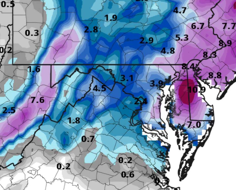
Disappointing to see the IVT pulling east on most guidance now. We were really relying on that feature out here in the Winchester area. Starting to get the feeling we'll be lucky to see a couple inches of slush on the grass at this point. -
Randy in his rental car right now getting the f*ck out of Houston lol

-
Feb 22nd/23rd "There's no way..." Storm Thread
WVsnowlover replied to Maestrobjwa's topic in Mid Atlantic
Just minor differences between the clown map and snow depth maps on the 12z gfs...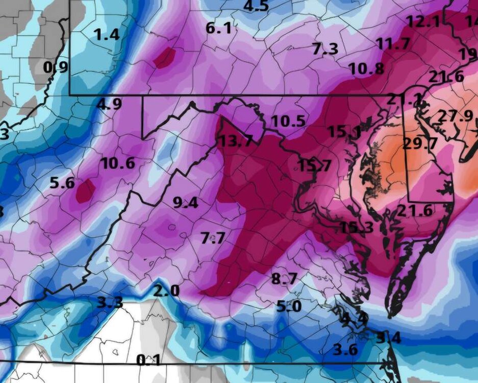

-
The Jan 31 Potential: Stormtracker Failure or 'Tracker Trouncing
WVsnowlover replied to stormtracker's topic in Mid Atlantic
That novelty wears off fairly quickly. It's all about the chase and the high that good model runs bring for most here. -
Question for anyone with more knowledge than me which is most on here...Does the kicker coming out of the NW still seem like it's going to be a key player for this storm? Are we better off of it slows down which should allow the storm to come up the coast more or would it be better if it speeds up and potentially phases?
-
I really don't mind where we're sitting right now. Trends are great and we still have time. I have a good feeling about this one for some reason. Tomorrow might be a really fun day of model watching! Here's to keeping the trend going for the 12z suite.
-
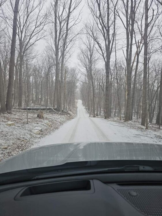
Light pixie dust here outside of Charles Town, WV.
-
I bartended there for many years when I was younger! It is an amazing place with great owners but they're the Asams lol .
-
January 24-26: Miracle or Mirage JV/Banter Thread!
WVsnowlover replied to SnowenOutThere's topic in Mid Atlantic

-
Sorry but you guys have had your share over the past few years. The far NW crew is beyond overdue. It will still be an epic storm for the entire board.
-
That's what the kuchera maps are for...
-
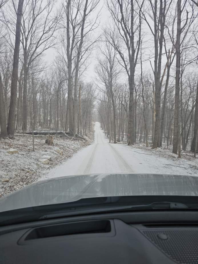
Currently a little west of Winchester. Just enough snow to make some of the roads a little slick.
-
But what fun would that be? Most on here should be smart enough to not take them for verbatim.