cbmclean
-
Posts
3,343 -
Joined
-
Last visited
Content Type
Profiles
Blogs
Forums
American Weather
Media Demo
Store
Gallery
Everything posted by cbmclean
-
January 28-29 2022 Miller abcdefu Storm Obs/Discussion
cbmclean replied to mappy's topic in Mid Atlantic
That is truly beautiful. -
Some people seem to get as much or maybe more more joy from others failing to get snow than from their own successes. It is actually quote a common attitude I have found, although I don't understand it myself.
-
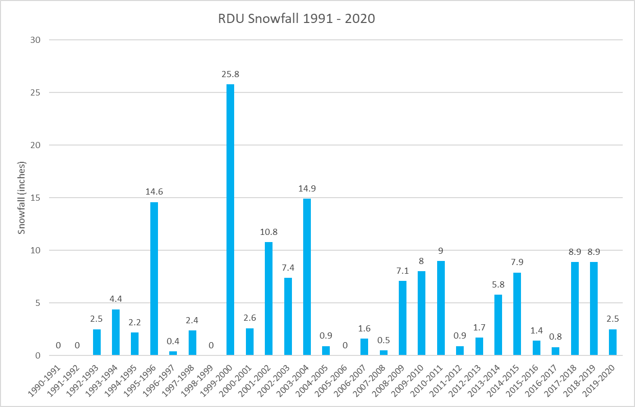
I found the numbers and crunched them. The RDU 30 mean for snow is 5.13 inches. The median is only 2.5 inches. So we are already above the median. 60% of years (18 of 30) during this period were below the mean. And if we didn't get any more snow it would only be the third consecutive year below the mean. 2018 - 2019 was well above the mean: 8.9 "
-
I just grabbed the monthly data from here https://www.weather.gov/wrh/climate?wfo=RAH You can also get the GSO data from there as well.
-
I personally find the shotgun/spread revolution less aesthetically pleasing than say the 1990's with fullbacks. The game has swung too much to the offense for my personal taste. Please note that I am just talking about my personal preference. I hate it when people try to argue that their personal likes are objectively superior and their personal dislikes are objectively inferior.
-
Conversely, the 1990s were a dark time.
-
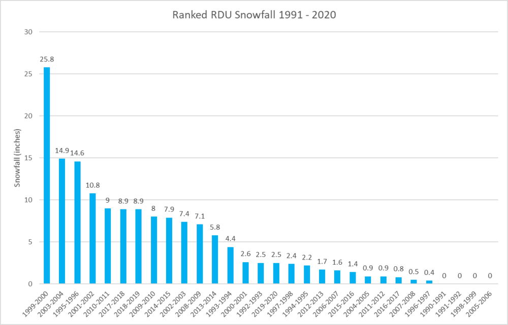
Here is a ranked graph of RDU snowfall from 1991-2020. Note the Carolina crusher sticks out like a beautiful sore thumb.
-
For RDU, the mean for 1981 - 2010 was 6.75 " so when we lost the 1980's our mean went down a good bit. Our median plummeted though. It was 4.25".
-
I will look in a minute, but first I have obtained the yearly snowfall amounts from 1991 - 2020. The median snowfall is......2.5 inches, less than half the mean! So RDU has already exceed its real "normal" snowfall for the year. Congratulations for us all. (note, I treat "T" as zeros in my calculations Here is the yearly data 1990-1991 0 1991-1992 0 1992-1993 2.5 1993-1994 4.4 1994-1995 2.2 1995-1996 14.6 1996-1997 0.4 1997-1998 2.4 1998-1999 0 1999-2000 25.8 2000-2001 2.6 2001-2002 10.8 2002-2003 7.4 2003-2004 14.9 2004-2005 0.9 2005-2006 0 2006-2007 1.6 2007-2008 0.5 2008-2009 7.1 2009-2010 8 2010-2011 9 2011-2012 0.9 2012-2013 1.7 2013-2014 5.8 2014-2015 7.9 2015-2016 1.4 2016-2017 0.8 2017-2018 8.9 2018-2019 8.9 2019-2020 2.5
-
What do you define as normal? For the 1991 - 2020 period, RDU "normal" (mean) is 5.2 inches: 2.6 in Jan, 1.4 in Feb, 0.3 in March, 0.1 in Nov, and 0.8 in December. I haven't been able to find the yearly numbers to calculate a median but I am certain it is significantly less than the mean.
-
Late January and February Medium/Long Range Discussion
cbmclean replied to WinterWxLuvr's topic in Mid Atlantic
Last year was very frustrating in that regard. It started in November, which was a ++++++AO nightmare which torched our source regions. That broke down but was instantly replaced with weeks-long Pac puke in December. By January even with great blocking there was no cold to be had in the entire hemisphere. By mid February that finally changed, but by then our blocking went "poof" and the cold dumped into the southern plains leading to historic events there. C'est la vie. -
Late January and February Medium/Long Range Discussion
cbmclean replied to WinterWxLuvr's topic in Mid Atlantic
To clarify, it might be better to say "good results are much less improbable in good patterns". Good results are still unlikely at our latitudes. Obviously in my neck of the woods that is even more true. -
Late January and February Medium/Long Range Discussion
cbmclean replied to WinterWxLuvr's topic in Mid Atlantic
Because good results are much more probable in good patterns and bad results are much more probable in bad patterns. -
Any one have the 1999-2020 raw data easily accessible for RDU? I am curious to compare the mean vs the median. I am guessing that at least 2 out of 3 years are below the 30 year mean.
-
The majority of years are below average at RDU when it comes to snow.
-
Its so safe you wouldn't believe!!!
-
The marathon man.
-
Potential 1/28-1/30 2022 winter storm
cbmclean replied to Prismshine Productions's topic in Southeastern States
Just when I thought I was out... -
Is it unhealthy that I attempted to hire some guys to break that SWs knees? But then I realized that that would just make it fall behind more.
-
I love the term "grandboss".
-
Late January and February Medium/Long Range Discussion
cbmclean replied to WinterWxLuvr's topic in Mid Atlantic
Isn't he from Richmond. We don't claim there. He's all you.- 4,130 replies
-
- 3
-

-
- prime climo
- cold canada
- (and 1 more)
-
Late January and February Medium/Long Range Discussion
cbmclean replied to WinterWxLuvr's topic in Mid Atlantic
I am curious how you extract vorticity consolidation, or lack thereof, from that map. -
Late January and February Medium/Long Range Discussion
cbmclean replied to WinterWxLuvr's topic in Mid Atlantic
I agree that the original post could have been interpreted as unnecessary jab at us in the SE, but the mockery of their snow disappointment was poor taste in my opinion. We had a good day today. Let's just enjoy the feeling without trying to poop on other's parade. -
Late January and February Medium/Long Range Discussion
cbmclean replied to WinterWxLuvr's topic in Mid Atlantic
I am embarrassed on behalf of the SE board. Not all of us are like that.- 4,130 replies
-
- 10
-

-
- prime climo
- cold canada
- (and 1 more)
-
Did the reaper wear shoes? I always envisioned him with boney feet.