

cbmclean
-
Posts
3,342 -
Joined
-
Last visited
Content Type
Profiles
Blogs
Forums
American Weather
Media Demo
Store
Gallery
Everything posted by cbmclean
-
What, if anything, are the potential implications for an SPV split in terms of sensible weather? I'm not really familiar with split PVs.
-
So does a split stratospheric PV mean anything for the lower troposphere?
-
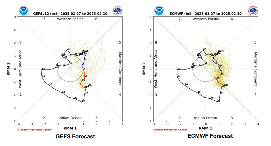
I will also note that not all of the GEFS members are that explosive into 6, with a sizeable number looking like the Euro. I wonder if the ensemble mean is being significantly skewed by the camp which is predicting explosion.
-
As Weather Will noted, GEF apesh!t SER likely stems from explosive intensification of the MJO into Phase 6 with one member bursting through the roof and apparently causing the world to incinerate. The EPS is much more restrained with a general prediction of progression through 6 into 7. We really want to get back to 8 to tart feeling better.
-
I protest at the use of the word "gorgeous" to describe a Bermuda High in winter.
-
Well you did have that glorious but brief Gheorghe Mureșan era. Seriously though I liked watching him play. He had some talent.
-
January Medium/Long Range: Chasing more snow to close out the month
cbmclean replied to mappy's topic in Mid Atlantic
So a warm period the first week of Feb looks highly likely barring some major modeling collapse (wouldn't it be nice if the warm pattern collapsed like last years epic pattern collapsed?) Looks like the crystal ball is very murky after that. As @psuhoffman has pointed out, historical analogs say a flip back to cold would be expected by the end of February into March. The real question as I see it is what happens the period of say Feb 10 - 24. -
January Medium/Long Range: Chasing more snow to close out the month
cbmclean replied to mappy's topic in Mid Atlantic
The GFS appears to be firmly in the camp of a longer tour through the bad phases of the MJO. May be contributing to that enhanced SER look. -
January Medium/Long Range: Chasing more snow to close out the month
cbmclean replied to mappy's topic in Mid Atlantic
I would call it more less troughing in the west. Still I'd rather have it go that way than the other. I tried to embed a trend GIF but it wouldn't work for me. I've seen people do it before. How do you do it? -
January Medium/Long Range: Chasing more snow to close out the month
cbmclean replied to mappy's topic in Mid Atlantic
The 10 HP winds are actually very strong this year or so I have heard, so no SSWs in the offing. As many have observed they are a crapshoot at best and absolutely undesirable with a good longwave pattern. -
January Medium/Long Range: Chasing more snow to close out the month
cbmclean replied to mappy's topic in Mid Atlantic
That event is fondly remembered in my sub for obvious reasons. -
January Medium/Long Range: Chasing more snow to close out the month
cbmclean replied to mappy's topic in Mid Atlantic
The upcoming 2030 - 2060 base period. -10 F equates to 60 F. -
January Medium/Long Range: Chasing more snow to close out the month
cbmclean replied to mappy's topic in Mid Atlantic
Are you familiar with Ji? -
I'm not sure I can handle another emotional roller coaster. If it's still there in 5 days I'll get invested.
-
When you outdo a day in Feb 1899 for cold, you have made an accomplishment.
-
Would you expect the PDO to impact the jet? I thought that was an independent problem due to the Hadley cell expansion.
-
I'm glad that is helping the cause this year, but it doesn't bode well for chances of getting a nice clean miller A in future Ninos if that Pac Jet stays permanently jacked up. I'm hoping it collapses...just wait til the end of this winter first .
-
Where do you view radar?
-
https://en.wikipedia.org/wiki/Snow_in_Florida
-
I'm glad to see you spell it right!!
-
So some years ago I thought the whole notion of "the models will change when the storm gets better sampled over land" was ridiculed into oblivion along with the "18Z models are trash" myth. I was told that the vast majority of model ingestion is from satellite soundings and that RAOBs were of much reduced importance. Now I'm hearing this idea being resurrected all over the place by people who seem to know what they are talking bout. So which is it?
-
Ah you're one of those types. Just Kidding. I vividly remember the dreaded snowline between Raleigh and Fayetteville from my childhood as well. When I moved to Greensboro for college I remember reveling in the marginal events that were snow there and rain back home.
-
Not disputing your basic point, but there were widespread -30s and I believe some -40s in the 2021 outbreak in the Midwest. Of course the east coast was completely shielded from that outbreak by our beloved friend, the SER.
-
Hey, which High School did you go to? I'm from Hope Mills.
-
Agreed. It would be about 0.9" more than I have seen in the last three tears combined..


