

jm1220
-
Posts
22,990 -
Joined
-
Last visited
Content Type
Profiles
Blogs
Forums
American Weather
Media Demo
Store
Gallery
Posts posted by jm1220
-
-
Rain with graupel here. The misery continues.
-
1.9" here. Backyard is a pond/swamp again.
-
Roads closing in Long Beach from flooding. Strong SE winds driving in water plus heavy rain.
-
45mph gusts at JFK and FRG.
-
 1
1
-
-
Upton talking up moderate coastal flooding for the S Shore back bays and 8-12 foot waves for the beaches. Won't be a severe erosion event most likely since this won't have time to build up a large fetch but any amount of erosion at this point is really bad news.
Nice afternoon for once. Flowers and plants are greening and blooming like crazy.
-
1 minute ago, bluewave said:
This is a much warmer version of the -PDO for us defined more by the record marine heatwave near Japan than the cold ring off of California.
Yep it’s crazy, and it must be driving these roaring Pacific Jet patterns that inundate us with warmth. In this era maybe the only way that changes is a competing marine heatwave somewhere else.
-
1
-
-
5 minutes ago, Brian5671 said:
I've seen 98-99 as a possible analog...yuck
Don’t think we can dispute the pendulum is slamming back the other direction after our big snow 2000-18 period. Until the Pacific meaningfully changes out of this crap SST orientation the odds are strongly against us.
-
1
-
-
3 minutes ago, MANDA said:
Thought this was interesting. La Nina seems to be coming on rather quickly as the Nino collapses. Will be interesting to watch this over the next weeks and months. That is some rapid cooling over a very short period of time. Latest EURO suggesting quite a busy Atlantic hurricane season.
Possible naming frenzy but impacts to be be determined.
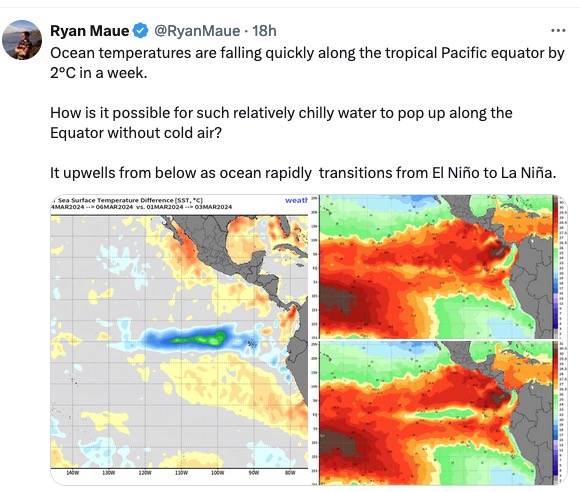
Yay Perma-Nina. The Nina hangover pattern never really went away this winter from the last one, we have a very -PDO and boiling equatorial WPAC, and now we have an official probably mod-strong Nina for next winter. Hopefully we get a high ACE and it’s an East based Nina or we’re in big trouble next winter too.
-
14 minutes ago, bluewave said:
Airports are just as good if not better for measuring snowfall and temperatures than the neighborhoods that are nearby. The actual ASOS is away from the concrete on grassy strips like a backyard in the adjacent neighborhoods. Those local neighborhoods also have streets and driveways which are also made of concrete. We could make the case that our local airports probably aren’t the warmest spots in our area since they are located very close to the water which are subject to cooling sea breezes during the summer. There are places more inland of Newark with more 90° days. Newark only ranks 4th in 90° days since 2010 due to the breezes off the bay since the ASOS is right on the water.
Data for January 1, 2010 through December 31, 2022
Click column heading to sort ascending, click again to sort descending.NameStation TypeNumber of Days Max Temperature >= 90HIGHTSTOWN 2 W COOP 465 HARRISON COOP 459 FREEHOLD-MARLBORO COOP 453 Newark Area ThreadEx 439 NEWARK LIBERTY INTL AP WBAN 439 CANOE BROOK COOP 438 New Brunswick Area ThreadEx 414 NEW BRUNSWICK 3 SE COOP 414 If Central Park can’t get its act together with measuring snow, official measurements for NYC should be moved to LGA. It’s about centrally located in the 5 boroughs, not far from Manhattan.
-
2
-
-
Up to about 2", maybe a little over. Outside looks like a swamp.
-
4 minutes ago, psv88 said:
2 inches now. Jackpot!
Yaay. The mosquitoes in a couple months will be something fierce.
-
 2
2
-
-
Up to about 1.3”. Some of these downpours are crazy. My backyard is turning into a pond.
-
17 minutes ago, the_other_guy said:
it would’ve been a snow rain event with a good dump upfront.
Long story short it’s just too warm to snow around here now and it’s been like that all winter. There’s no March snowstorm coming to save the day.
You need absolutely perfect conditions at this point to get snow around here and that really only happens in the heart of winter
No more snow, but of course the misery's nowhere near done.
-
20 minutes ago, the_other_guy said:
Today was your March snowstorm. 10 degrees too warm for it.
Today would’ve been rain any time of the year. This is a hugger that would’ve driven warm air in for the coast. Well inland might’ve stayed snow.
-
 1
1
-
-
40 minutes ago, Volcanic Winter said:
We’re probably “due” for some landfalling tropical systems up here. We’ve really only had Isaias (which I remember as pretty wild given what it was at the time) and the remnants of Ida which of course spawned the great NJ EF3 and associated outbreak, along with crazy flooding in the northern metro. Perhaps this year we see more east coast / northeast landfall risk?
Always thought it was pretty wild how we had Irene and Sandy back to back, the former a significant impact and the latter historic. Probably sooner or later we’ll see the next one. I do enjoy a good tropical system (hurricane parties are fun, we evacuate my parents out of Seaside and gather at my sister’s place inland). But I think the risks from a Cat 2 + are probably too great to really be exciting anymore, probably more when I was a kid. It’s been a while since we’ve had a stronger storm up here, you’d think it’s a matter of time with the warmer SST profiles in the Atlantic. Just need a relatively fast mover without too much prior surface churn.
Think my oldest tropical system memory was when I was a little kid at my parent’s place in Seaside while Bob scraped by the immediate coast. Pretty sure that’s the one I remember though ofc it wasn’t a big deal here.
The place that’s really due is SE FL from PBI to Miami which hasn’t really been hit since 2005 by a major. Up here it seems like the tropical systems come in waves like 2011-12, and 1938-54. We probably are due for another storm like Bob that hit eastern LI and New England hard.
-
1
-
-
2 hours ago, bluewave said:
No cold air.

Well-plenty of Irish green for temps and this winter into spring probably rain too.
-
67 in S Nassau around Sunrise Highway.
-
1
-
-
61 here. Stunning! And this time of year temps often bust warm when we can keep the sea breeze away. No leaves on the trees yet is why.
-
4 minutes ago, LibertyBell said:
but sun over rain any day unless it's a drought
It’s almost impossible to sustain any long term drought here because of how many ways we can get heavy rain. And the average precip has been increasing significantly in the last few decades.
-
1
-
-
1 minute ago, donsutherland1 said:
Some points about the 12z GFS's Day 8-9 Storm:
1. The GFS is in a timeframe where skill is low
2. The GFS lacks support from other global models and the ensembles
3. The GFS's soundings show readings remaining above freezing throughout the stormNew York City's Above Freezing Snowfalls:
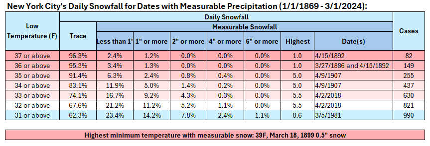
In short, unless there is more than a marginal air mass and strong support from the other guidance, one should be skeptical of the snowfall amount (7.8") shown on the GFS. Ratios for any snow would be far lower than 10:1.
Thanks for the reality check. There's very little cold air to speak of around the area going into this storm, so any storm we'd have would have to manufacture its own through crashing heights. If there's heavy snow the temp should crash to 32-33 but we'd probably waste some/a lot on white rain and getting it to accumulate. And of course this is at Day 8 anyway.
-
3
-
-
1 hour ago, psv88 said:
Nobody wants snow after march 1. Time for baseball, beach and boating. LFG
If it’s a 6”+ event I’d be interested but if it’s some slop that’s gone the next day I really couldn’t care less. This event is still 8 days away and even though the pattern does become more favorable it probably just matters for upstate NY and New England. Boston will probably find some way to make it over 10” for the winter-that’s obscenely low for them.
-
12 minutes ago, MJO812 said:
Gfs to our north shows a snowstorm
Good for them.
-
Garbage pails blown everywhere in my backyard and part of gutter blown down. Pretty wild is right.
-
1
-
-
Brief shower here. Looks like the bulk of it is south of me so this should be about it.
-
1
-

March 2024
in New York City Metro
Posted
If this late month cold shot is happening we'll definitely go below again a few times. And that will damage some of the plants that will bloom this week in the upcoming warmth.