

jm1220
-
Posts
22,944 -
Joined
-
Last visited
Content Type
Profiles
Blogs
Forums
American Weather
Media Demo
Store
Gallery
Posts posted by jm1220
-
-
51 minutes ago, Brian5671 said:
Looks like a SE ridge there-maybe the blocking can link up and give us warmth...LOL
If there’s a big closed off low east of us the only result will be easterly winds and low clouds. We’d want some kind of westerly flow to warm us up and keep it dry.
-
 1
1
-
-
55 minutes ago, Allsnow said:
Brutal…
Shows up right on schedule to trash the start of spring.
-
1
-
-
One or two more of these and we’ll spontaneously transform to a rainforest. The water table’s so high that I’m sure many basements will start flooding with any more rain much less 2-3”+.
-
1
-
 1
1
-
-
2 hours ago, Allsnow said:
Reports up north of 7-8 inches of snow with 3 inches of sleet…
I would love to experience that
For the Valentines Day 2007 storm I lived in Central PA. That's exactly what it was-probably 8" of snow in 3" of sleet. 4" of snow then the sleet and 4" at the end that added up to 10-12" of absolute cement. Temps were in the teens to around 20 the whole storm. That seriously was the heaviest, densest concrete I remember falling out of the sky. It froze solid and lasted for weeks. In other parts of the state it was so disruptive that major roads/interstates shut down because it's so hard to move. I think in that storm much of this subforum had a big ice event. Much of upstate NY/NNE had 24"+ which I would've much rather experienced, but all the dense sleet made what I had probably just as disruptive. The St Patricks Day 2007 storm I was home on Long Island and remember the insane amount of sleet from that one. So that month long period I saw more sleet than any other time in my life.
-
1
-
-
11 minutes ago, MANDA said:
Nice snow cover from western NY into CNE/NNE.
Albany lucked out with 5-6" at the end but ouch that 20 miles or so north never mixed and got 18".
-
@uofmiami Did you send your rain total to Upton? Most recent amount they have for Syosset is 3.7”.
-
1
-
-
3.8” for me, over 4” very close by. Syosset I think ended with 4.2” and all NYC sites over 3”. Any more of these and the island will sink under.
-
1
-
-
Larkfield Rd in Commack closed from flooding. At least this time it didn’t shut down Jericho Turnpike. Huntington Village flooded pretty good too, that’s where there were amounts over 4”. Otherwise getting pretty gusty now.
-
2
-
-
1 minute ago, LibertyBell said:
yep, March 2010 and the great summer of 2010....
March 1993 and the great summer of 1993.....
Another very stormy Nino March.
-
 1
1
-
-
22 minutes ago, Roger Smith said:
Early reports so far:
3.43" at NYC
3.20" at LGA
2.97" at EWR
2.82" at JFK
Adding up the hourly totals at JFK I got 3.12", LGA 3.44", Central Park 3.63 and EWR 2.86" (missing data?)
-
1
-
-
Looks like 3.8" will do it here. Kudos to the HRRR for nailing the heavy rain just north of the warm front and developing band with the cold front. Still have 7 days left with many/most of us over 10" now for the month.
-
1
-
-
Even better, tonight it will probably get below 30 here. Wonder how much of this will ice up. Still raining moderately. Closest gauge to here says 3.48". Seeing 4.02" in Huntington Village just north of here and some over 4" in N Nassau.
-
1
-
-
2 minutes ago, lee59 said:
2.70 inches here and still raining. The snow line is drifting south and east. Wind has switched to west here. Now snowing in the Albany area and the Catskills.
That heavy band is the front/wind shift line.
-
13 minutes ago, weathermedic said:
Nice squall line developed over Long Island and entering Suffolk County now.
Absolutely dumping here in that band. My backyard's drowned.
-
Heavy rain band w/the front that was advertised on the hi-res models is getting together and coming east. Yard is a pond again and more to come. We're turning into a rainforest.
-
2
-
-
25 minutes ago, lee59 said:
Looks like a lot of ice in the Albany area. Lots of snow to the north and Northeast
Definitely a big event for Glens Falls/Lake George area. Good for them.
Downpouring here currently. I'll probably make it to 3". We'll see what happens further east where the relatively spared zone's been so far.
-
1
-
-
2 minutes ago, ag3 said:
Up to 1.89” here on my home gauge.
We’ll probably end well over 3”, outside chance at 4” in a few spots. Drenching until 4-5pm.
-
1
-
-
5 minutes ago, ag3 said:
Hrrr and short range models have this ending faster than modeled. By 3-5 pm.
Matches radar, IMO.
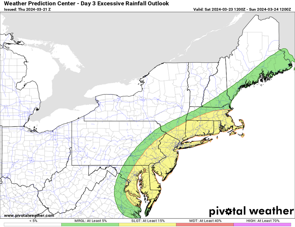
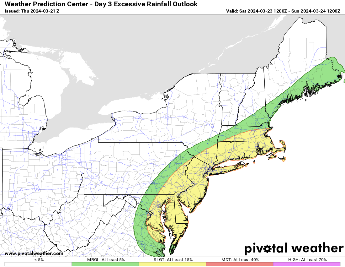
Usually happens with these. No mid level closed low to slow it down. Should still be some heavy rain amounts though north of the warm front where lift is strong. W Suffolk through NE NJ/Hudson Valley/S CT should get drenched in the next few hours.
-
1
-
-
5 minutes ago, uofmiami said:
Ski resorts up there will be happy.
March even into April is some of their prime season in NNE/Adirondacks ski country.
-
1
-
-
1 hour ago, Brian5671 said:
HRRR coming in very wet

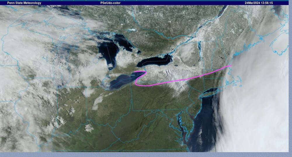
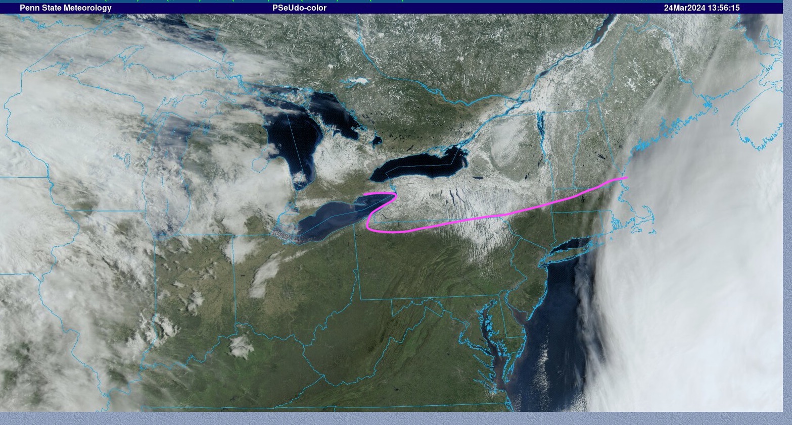
RGEM continues to nail MBY but some of the hi res models especially are worst over the usual suspect NJ/Hudson Valley areas. I'll be perfectly fine with getting relatively spared.
-
13 minutes ago, bluewave said:
The really damaging freeze around the region was last May when some spots in Upstate NY got down into the low 20s.
https://www.wamc.org/2023-09-19/a-late-may-frost-caused-some-ny-farms-to-lose-most-of-their-apples
The evening of May 17 Critz turned on a large frost fan which helps mix warmer air from above with cooler air at ground level to try and prevent frost forming on the flowering trees. Then the temperature dipped down to 23 degrees.
"32 is okay," Critz said. "30, 29, you start having a little damage maybe 10 percent. You can go down to like 27 you'd be like 50% damage, but usually there's enough blossoms even if you lose 50% of them, you're still going to bear a good crop. Then it went down to 23 and just killed everything."
The apples he does have, have a frost ring around them. These apples will be pressed to make sweet cider and hard cider.
Last year or the year before GA had a very damaging freeze for the peach crop after a freeze hit right after our new normal much warmer than average “winter” started the growing season early. Maybe this will be a more frequent occurrence in this new climate normal with the growing season starting earlier and earlier but still prone to cold snaps.
-
The blossoms here mostly look fine even though we got down to 24 last night. Guess they can be pretty hardy.
-
Got down to 24 here.
-
3 hours ago, Rtd208 said:
HRRR is a drencher so far. 0z has 4" on the NJ shore and NYC, 3" just about everywhere else.
-
1
-
March 2024
in New York City Metro
Posted
RGEM looked pretty far east with the rain late week. Good. Keep it away