

jm1220
-
Posts
22,976 -
Joined
-
Last visited
Content Type
Profiles
Blogs
Forums
American Weather
Media Demo
Store
Gallery
Posts posted by jm1220
-
-
5 minutes ago, uofmiami said:
Ski resorts up there will be happy.
March even into April is some of their prime season in NNE/Adirondacks ski country.
-
 1
1
-
-
1 hour ago, Brian5671 said:
HRRR coming in very wet

RGEM continues to nail MBY but some of the hi res models especially are worst over the usual suspect NJ/Hudson Valley areas. I'll be perfectly fine with getting relatively spared.
-
13 minutes ago, bluewave said:
The really damaging freeze around the region was last May when some spots in Upstate NY got down into the low 20s.
https://www.wamc.org/2023-09-19/a-late-may-frost-caused-some-ny-farms-to-lose-most-of-their-apples
The evening of May 17 Critz turned on a large frost fan which helps mix warmer air from above with cooler air at ground level to try and prevent frost forming on the flowering trees. Then the temperature dipped down to 23 degrees.
"32 is okay," Critz said. "30, 29, you start having a little damage maybe 10 percent. You can go down to like 27 you'd be like 50% damage, but usually there's enough blossoms even if you lose 50% of them, you're still going to bear a good crop. Then it went down to 23 and just killed everything."
The apples he does have, have a frost ring around them. These apples will be pressed to make sweet cider and hard cider.
Last year or the year before GA had a very damaging freeze for the peach crop after a freeze hit right after our new normal much warmer than average “winter” started the growing season early. Maybe this will be a more frequent occurrence in this new climate normal with the growing season starting earlier and earlier but still prone to cold snaps.
-
The blossoms here mostly look fine even though we got down to 24 last night. Guess they can be pretty hardy.
-
Got down to 24 here.
-
3 hours ago, Rtd208 said:
HRRR is a drencher so far. 0z has 4" on the NJ shore and NYC, 3" just about everywhere else.
-
1
-
-
44 minutes ago, Brian5671 said:
Euro is a monsoon through next weekend

Everybody double check your French drains.
-
Models flipping wetter again at 12z. CMC has 4” for parts of LI. Quite the nice CCB that develops and nails most of us on Saturday. Too bad there’s zippo cold air until you’re well north into NY State/NNE. Could’ve been very nice if some cold air could stay around beforehand with this track/evolution.
-
31 minutes ago, snowman19 said:
That should be a really good trick with 50’s and 60’s
Maybe LibertyBell can suggest a chemical we can mass release into the atmosphere/oceans to raise the freezing point of our water and make it be able to snow at 50 degrees.
-
 8
8
-
-
28 here.
-
1 minute ago, SnoSki14 said:
Tomorrow in the burbs will be very cold. Could easily go below forecast.
Low 20s will do damage but it's still pretty early in the growing season even with all this warmth lately.
I think generally it'll be okay here, again if it holds the bugs/mosquitoes off for a while I consider it a win. All this rain will mean swarms of them soon.

-
46 minutes ago, donsutherland1 said:
Boston has never had two consecutive seasons with less than 20" of snow. The lowest two season average was 17.4" (1979-80 and 1980-81).
Yikes. I think their worst snow season ever is only a few tenths below this winter.
-
1
-
-
3 minutes ago, psv88 said:
28 degrees won’t do much damage. This isn’t like the late season one we had some years back which was devastating
Point and click here is 27 degrees tonight and 24 tomorrow night. Tomorrow night might be pretty bad if winds go calm, and often our low goes below the point/click.
-
1
-
-
24 minutes ago, donsutherland1 said:
A strong cold front is crossing the region. Already, the temperatures is falling from New York City westward.
The low temperature will likely approach or reach freezing tomorrow and Friday morning in New York City. Readings in the 20s are likely well outside New York City, Newark, and Philadelphia.
A storm will likely bring a windswept 1.00"-3.00" of rain with locally higher amounts during the weekend. Significant coastal flooding at high tide and beach erosion are likely.
Milder air will also begin to return during the weekend. The closing days of March could turn warm.
It is very likely that New York City's Central Park will finish the 2023-2024 snow season with less than 10" of seasonal snowfall for a record second consecutive season. Records go back to 1869.
The ENSO Region 1+2 anomaly was +0.4°C and the Region 3.4 anomaly was +1.1°C for the week centered around March 13. For the past six weeks, the ENSO Region 1+2 anomaly has averaged +0.88°C and the ENSO Region 3.4 anomaly has averaged +1.42°C. The ongoing basinwide El Niño event is now fading. Neutral conditions could develop during the spring.
The SOI was +3.25 today.
The preliminary Arctic Oscillation (AO) was -0.827 today.
Based on sensitivity analysis applied to the latest guidance, there is an implied near 100% probability that New York City will have a warmer than normal March (1991-2020 normal). March will likely finish with a mean temperature near 48.0° (5.3° above normal).
I wonder if Boston has ever finished with 2 winters in a row under 15"? I think last winter they had just under 13" and this winter under 10" as well. It's just as bad there/even worse based on averages.
-
1
-
-
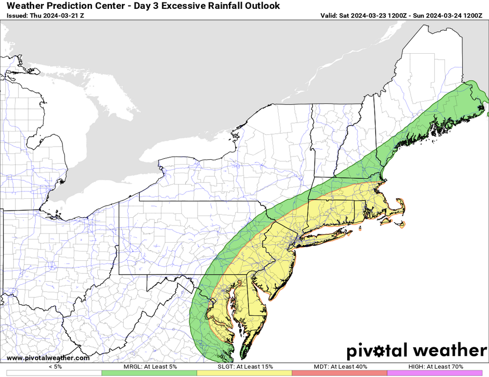
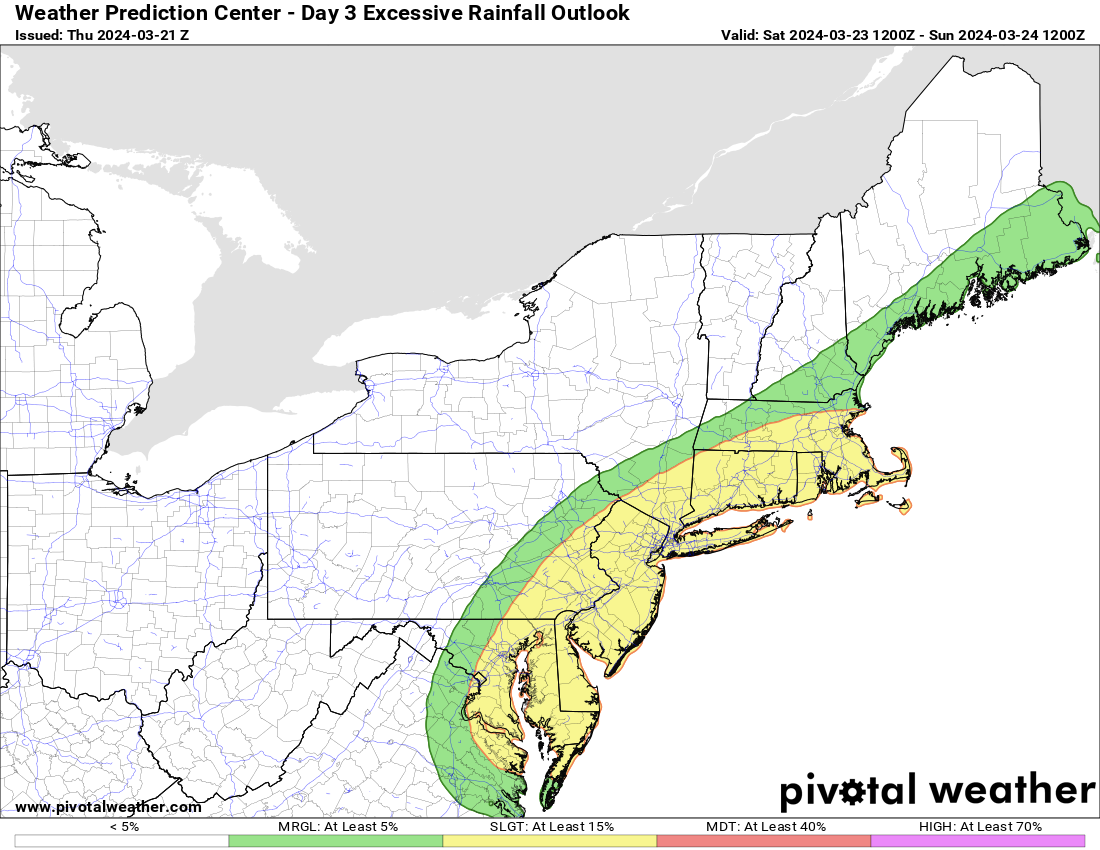
 at some of the model trends for this weekend. Good thing the rain’s desperately needed and there’s plenty of sand left to be eroded on the beaches!
-
1
-
 1
1
-
-
27 minutes ago, MJO812 said:
Great pattern ahead to be in the midwest and Caribou.
So lucky
MSP is well below average in snow so it’s much needed there as well as ME also well below average. They’re far enough north that they can do well in late March and April. Unless it’s a miracle season like 2018 we’re shut out this far south. And with the likely Nina next winter they’ll probably more than make up for this awful one.
-
40 minutes ago, bluewave said:
Much more model spread than we typically see around 5 days out. The potential for heavy rains is there if everything gels. But this is a lower confidence forecast than usual since cutoffs in spring are the hardest for models to resolve. Each model has a different low position at 120 hrs.


Who needs south shore beaches anymore anyways? This one if it sits for a couple days might be a TKO.
-
6 minutes ago, AstronomyEnjoyer said:
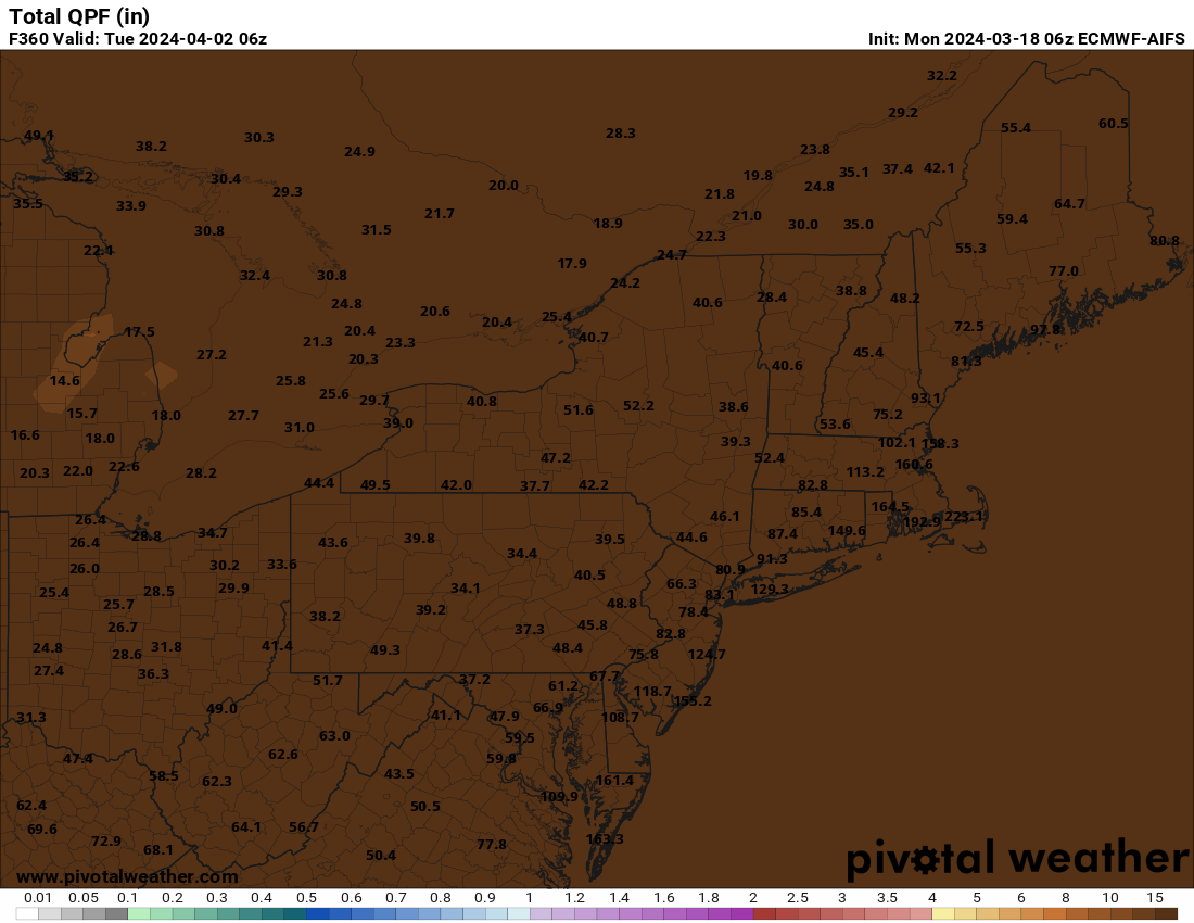
Pivotal is having some kind of issue handling QPF mapping on the Euro AI. I don't think this is correct. Methinks there is a bug afoot!
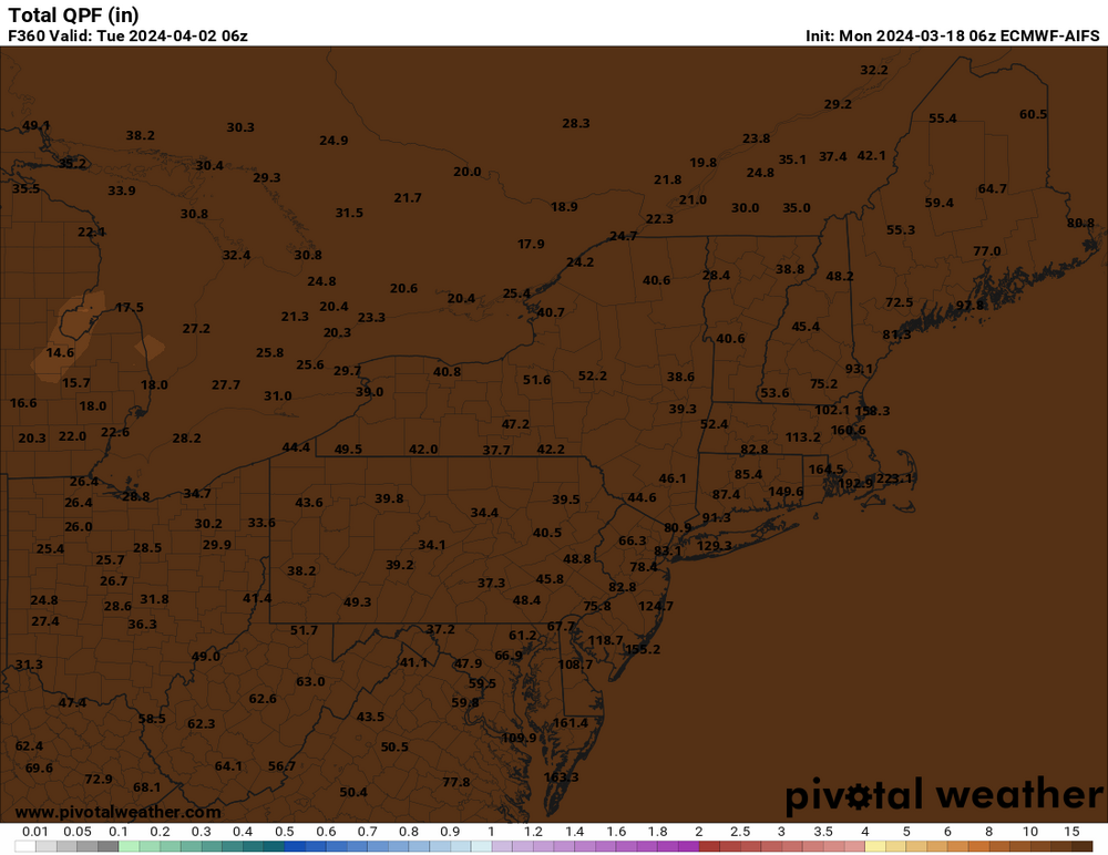
We’re getting a sneak peak of its plan to destroy humanity by drowning us?
-
1
-
2
-
-
4 hours ago, psv88 said:
Which is…normal
There once was a time 6 years ago when there was 20” from one storm across parts of LI. Remember ye olde days?
-
1
-
-
31 minutes ago, NEG NAO said:
good - this early blooming is the earliest I have seen and the birds are chirping outside at 4 AM - maybe the cold will shut them up too till dawn.......
It’ll hold the bugs off for a while which is always good.
-
42 minutes ago, SnoSki14 said:
Looks like multiple freezes and even hard freezes likely just outside the city and immediate coast coming week.
Should put a damper on any early blooms and leafouts.
Yep, even in this climate we’re almost guaranteed another couple of freezes outside the city.
-
70 even on the south shore barrier islands with the W wind. Long Beach also near 70.
-
70 once again today. Again well warmer than forecast.
-
Spring is mostly nicer SW of Philly where back door fronts are rare. Here and NE of us it’s often miserable because of them. Always dreadful to see the closed upper low develop east/NE of us and you know it’s drizzly stratus and 40s for days.


March 2024
in New York City Metro
Posted
Usually happens with these. No mid level closed low to slow it down. Should still be some heavy rain amounts though north of the warm front where lift is strong. W Suffolk through NE NJ/Hudson Valley/S CT should get drenched in the next few hours.