

jm1220
-
Posts
26,108 -
Joined
-
Last visited
Content Type
Profiles
Blogs
Forums
American Weather
Media Demo
Store
Gallery
Posts posted by jm1220
-
-
Not quite nailed here in Chicago today but annoying moderate to heavy rain. Looks like it’ll be cleared out soon.
-
Looking like we get nailed yet again in Chicago. South of Aurora looks like 70mph velocities. That part looks to slide to the south of here but another part of the line to the north looks like it’s bowing out. Hope this is done tomorrow when I fly home and it’s out in time for fireworks.
-
 1
1
-
-
17 minutes ago, psv88 said:
Chicago getting crushed
Yep, nailed twice today. This afternoon’s were pretty crazy, wind must have gusted to 50 where I’m staying. Quite a bit of tree/property damage around the city.
-
Midwest thunderstorms are something else. Getting hit here in Chicago and the lightning is just constant. Tomorrow's a slight risk.
-
 1
1
-
-
1 hour ago, SACRUS said:
Dewpoint temps slowly creeping back up to the low 70sThe heat index actually jumped to 105 at Farmingdale when the seabreeze came through because the dewpoint jumped from 63 to 71. By August the seabreeze won't be any relief anymore and just makes it worse.
-
 1
1
-
-
Now imagine this every single day for 3-4 months, with a stronger sun since you're in the South. That's TX and what I dealt with in 2015-16. And no, in Austin it's not a dry heat. I hated it really quick-you can't do anything outside until the evening or early morning, and even in the evening it's often still in the upper 90s. I went from record never ending deluge in May 2015, historic Memorial Day floods and severe to not a drop after in June and baking until October when we had another record deluge from the remnants of Hurricane Patricia.
-
4
-
1
-
-
Just now, LongBeachSurfFreak said:
Only a light wsw wind at jones beach currently. As much as I would love a raging Ambrose jet today, I’m not seeing it. Water temp also plummeting with westerly component to the wind.
.HRRR looked good for it yesterday. We'll see.
-
1
-
-
26 minutes ago, MJO812 said:
Jeez its already 95 here in Brooklyn. Air conditioners going full blast inside my house.

Get on the LIRR to Long Beach lol. Do it early before the 40mph onshore winds happen.
-
3 hours ago, TJW014 said:
Just got out of the water. It's freezing. 4mm wetsuit, no boots. Water temp of 54 according to my watch, and that typically reads 1-2 degrees warmer.
Sea breeze already in effect, should keep the beach in the low 80s again
Long Beach 78-80, Captree's 72. We'll see how much higher it gets. Probably a few more degrees but today looks like a good Ambrose Jet day.
-
2
-
-
1 hour ago, Snowlover11 said:
Why does upstate ny and new england get whacked constantly with storms but we cant get shit here.
The Ring of Fire around the ridge. My turn here in Chicago is on Saturday-I'm flying out on Sun so hopefully we're done then and maybe it'll be severe I get to see. Suffolk got hit this morning and much needed. We're in convective season where synoptic systems don't happen other than anything tropical. The south shore LI pretty much goes into a 3-4 month drought because of all the storms that die before making it there.
-
1
-
-
1 hour ago, psv88 said:
Maybe. We’ll see
WNW winds will determine. Probably Ambrose Jet tomorrow so that's shot.
-
1 hour ago, Psychguy said:
Heat index topped out at 110 here in Philly today... now 91 with a tropical dew point of 76.
I was at a Phillies game one day during a heatwave there. Absolute torrid hell.
-
1 hour ago, bluewave said:
Tomorrow looks like a good Ambrose Jet day with the record heat west of the sea breeze front.
Looking like Fri may be the one hot day near the south shore. I don't think the barrier islands got above 80 today and may not tomorrow either.
-
1
-
-
38 minutes ago, FPizz said:
My station and the ones on my block were 98 today. One of my stations got to 100, but it runs warm. Im going with 98. Glad to be in the "cool" Aruba weather lol
Disgusting here in Chicago but not terrible on Navy Pier by the lake with a breeze.
-
3
-
-
1 hour ago, MANDA said:
Came across this kind of by accident just now.
This is "Earthlight" who used to be a regular and great poster on this forum.
Wishing him well. Way too young for this. Jeez.
Damn, hope he’s okay. Here in Chicago it’s already stifling this morning.
-
2
-
-
1 hour ago, dmillz25 said:
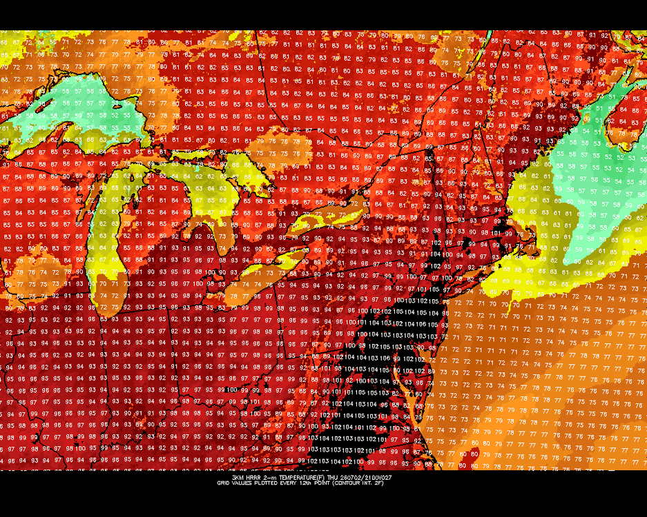
Nope the park hits 100 easily im not that type to hype shit but this has the makings of an historic heatwave
If we moved the site any distance away from the tree canopy it would be 102-103 easy. It’s ridiculous this is still an issue, and it’s the “official” climate site for the city.
-
3
-
1
-
-
2 minutes ago, dmillz25 said:
The Knicks win a championship, a top 5 blizzard and the first 100° temp since 2012 lol NYC winning
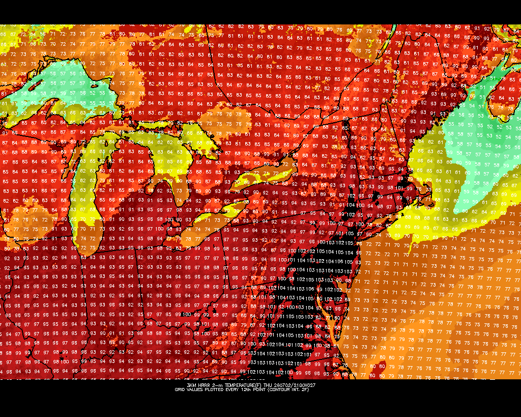
If you mean Central Park highly doubt it. My guess at airport high for this event is EWR hits 105 on Friday. Central Park probably tops out at 98-99.
-
45 minutes ago, Rjay said:
Which sucks bc it kills the old storm threads. This site is frustrating af.
Yep, this winter I had go back over a year and delete tons of screenshots and pics so I could post any new ones.
-
4 minutes ago, TWCCraig said:
86 yesterday on the south shore
For Long Island, the Euro has a prominent sea breeze on Thursday so Euro only has 90s for the island that day. West wind comes back on Friday (Euro) so that would be our best chance at 100+. GFS has more of a westerly wind both days but there will probably be a sea breeze both days. Where it sets up during the day will dictate the max temps. Longer it holds off, the hotter it'll get
Also where there’s any compressional heating zone. That area just ahead of the seabreeze can really roast. Sometimes that’s around the Southern State Parkway/Five Towns to Roosevelt Field.
-
3 minutes ago, adam7288 said:
It isn't political if someone is commenting on (with actual caveats) the reason why a website went down. It isn't opinion based, or leaning to some kind of political affiliation.
As someone who does not want politics in this forum either, this does not meet the criteria for that by a long shot, and you need to check yourself. Being hypersensitive does not serve our goals either.
Cool.
-
 1
1
-
1
-
-
Stop with the political stuff. Please and thank you.
-
6
-
 1
1
-
 1
1
-
-
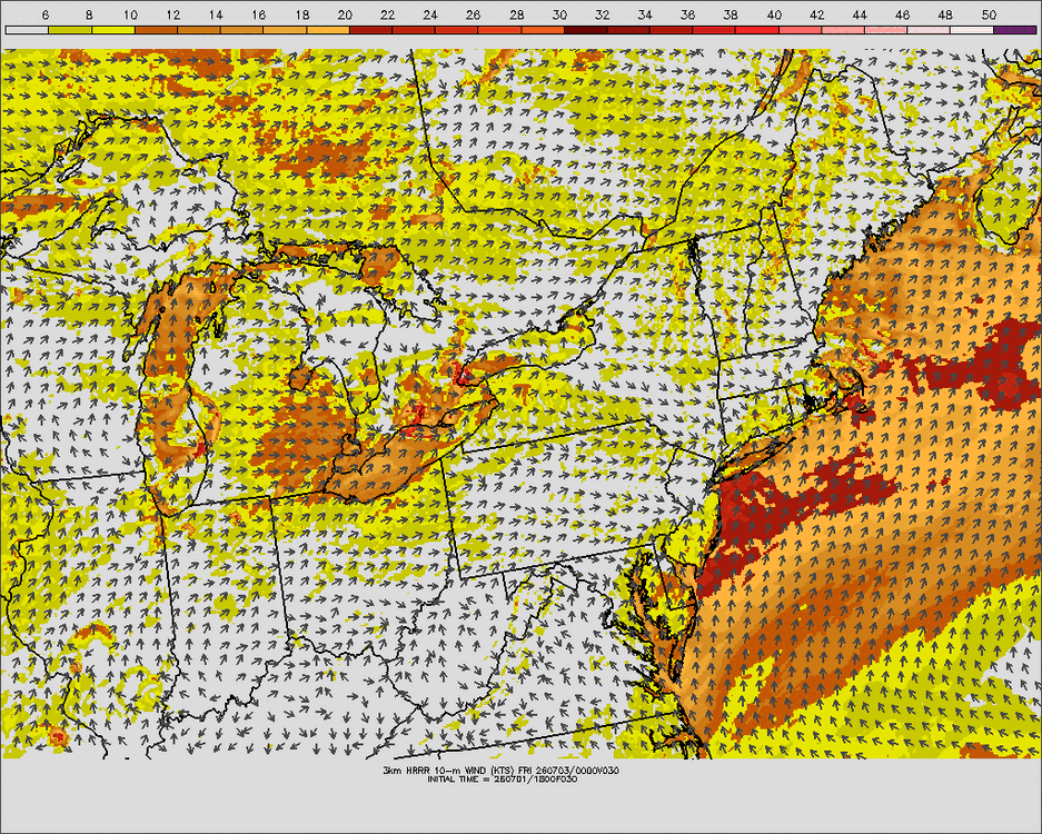
Thu and especially Fri look like the days that the coast could really rocket. 850s reach 24-25C on Fri so that should be the peak of the heat. Tue looks like strong onshore flow and maybe even Ambrose Jet. Wed the higher 850 temps over 20 move in but also maybe some storms along the periphery of the ridge. Sat-Sun the ridge looks to weaken and start to break down.
-
1 hour ago, TJW014 said:
Sea breeze always wins out along the coast with this heat. Upper 80s will feel fantastic next week and the weekend.
Ocean temps finally warmed to where I can tolerate it without a wetsuit.
On the barrier islands sure but just inland away from them made it to 100 during the heat last summer since we had an established WNW downslope flow. We’ll see if that holds this time but it might be very impressive near the coast where that offshore flow can maintain.
-
2 hours ago, LongBeachSurfFreak said:
It’s going to take EWR making a run at 110 for cpk to hit 100. Thursday looks like a solid JFK 100 plus day with a west wind until late afternoon
.On those days the south shore can be the hottest in the whole area because of compressional heating. Around the Southern State and Hempstead/Garden City are usually the hot spots.

July 2026
in New York City Metro
Posted
After the rain we were socked in fog in Chicago. I think the city did its fireworks show but you couldn't see it and could barely hear it. Sad/ridiculous. Should've been postponed.