

jm1220
-
Posts
22,944 -
Joined
-
Last visited
Content Type
Profiles
Blogs
Forums
American Weather
Media Demo
Store
Gallery
Posts posted by jm1220
-
-
Bayville and Eatons Neck both had 68mph gusts. They’re windy spots in any easterly wind events but no doubt the HWW verified. Also looks like numerous large branches/some trees down around the island. Rain generally 2.5-3”.
-
23 minutes ago, LibertyBell said:
it's bright and sunny here now with lots of blue skies lol-- so much for cloud cover forecasts, they can't even get it right on the same day!
Will cloud back up and more showers with the upper low swinging through.
-
 1
1
-
-
Usual places like Lindenhurst and Freeport flooded during high tide. Beaches took a pounding again looks like.
-
10 minutes ago, donsutherland1 said:
Rain and wind will continue into tomorrow with temperatures mainly in the 40s. A storm total 1"-3" rainfall with locally higher amounts is verifying across the region.
Coastal flooding at times of high tide is likely. Central and upstate New York and central and northern New England could see accumulating snow, especially in higher elevations and away from the coastline.
After a cool first week of April, it will likely turn noticeably warmer during the second week of the month.
It is very likely that New York City's Central Park will finish the 2023-2024 snow season with less than 10" of seasonal snowfall for a record second consecutive season. Records go back to 1869.
The ENSO Region 1+2 anomaly was -0.4°C and the Region 3.4 anomaly was +1.0°C for the week centered around March 20. For the past six weeks, the ENSO Region 1+2 anomaly has averaged +0.42°C and the ENSO Region 3.4 anomaly has averaged +1.27°C. The ongoing basinwide El Niño event is fading. Neutral conditions could develop later in the spring.
The SOI was -11.47 today.
The preliminary Arctic Oscillation (AO) was -0.368 today.
I think it’s time to pull the plug and call time of death on any chance of NYC making it to 10” snow this winter

-
1
-
-
13 minutes ago, Intensewind002 said:
Winds seem to be picking up again, Ill admit I was wrong when I stated the winds were only gusting to the 40s some widespread 50+ in the lastest PNS https://www.weather.gov/media/okx/windpns.pdfhttps://www.weather.gov/media/okx/windpns.pdf
In terms of rainfall, 2.24” here in Lindenhurst. On a side note it looked like a tropical storm outside at times with the heavier rains earlier today, definitely didn’t feel like one though with the wind chill around 30.
In Melville this afternoon the flags/branches were being blown around pretty good and rain in sideways sheets. Definitely a tropical storm vibe.
-
46 minutes ago, Intensewind002 said:
Im going to have to agree honestly, peak gusts were probably around 45 mph or so here. There were definitely worse storms wind wise this past winter.
JFK gusted to 54mph so far, I think HWW criteria is 55+. I’m sure a number of areas met it so far. Not to the point there’s widespread damage but the “nasty meter” today definitely off the charts.
-
1
-
-
37 minutes ago, psv88 said:
2.13” for the event. Long Island is turning into a swamp. After these events ground is soaked and water ponding everywhere. Make it stop
5th or 6th time in the last few months my backyard became a pond.
-
6 minutes ago, Allsnow said:
Lots of convection forming sw of the area. 1-2 more inches definitely possible
The secondary low forming means lots more rain for us.
-
1
-
-
Pouring and windy in Melville.
-
Just now, uofmiami said:
I think he's been off the rails longer than that, but that's for an entirely different thread IMO.
It took basic pattern recognition to realize that this was never a storm in terms of snow for us, and would be dicey in SNE but a fairly small shift would’ve kept it interesting along I-90. There’s as usual no preexisting cold to speak of, it’s another storm packed with moisture and the SE ridge is trying to make it cut as much as it can. Even if there’s a NAO block, we’re in trouble with the mega SE ridge. And oh by the way, it’s April.
-
2
-
-
8 minutes ago, MJO812 said:
The southeast ridge keeps screwing areas.
If it’s getting to the point now where SE ridges will regularly link up with the -NAO which negates the benefit of blocking episodes, we’re in big trouble and probably SNE too. Not sure if there have been historical periods where this happened.
-
1
-
 1
1
-
-
22 minutes ago, Brian5671 said:
Unreal. Even here I had two 6 inches snowfalls in each of the last 2 horrid winters
Looking pretty likely Boston ends under 10” for the winter which is absolute basement level disaster. Even I had 15.5” this season. If you take the last 4 winters from 20-21 on it’s been about as good here on the LI N Shore as it’s been there-and of course the last 2 winters have been complete trash. 21-22 was better there but 20-21 better here.
Looking quite dicey on the coastal flood threat tomorrow AM, major flood predicted in Freeport and moderate to major almost everywhere else on the S Shore bays. That plus maybe 2” more rain will means lots more flooding everywhere. Power might be out/trees down as well if these 60 mph gusts happen on saturated ground.
-
5 minutes ago, Brian5671 said:
The only difference is the winds are straight out of the east...usually we see these HHW with S or SE winds. There's a map in the NE thread showing winds 60mph for CT shore and LI but again likely overdone.
More worried about the coastal flood threat again. Hopefully that’s overdone too. The beaches/bays can’t take any more of it.
-
Sounded like some sleet pellets mixed in with this shower.
-
Already about 0.9” from this at JFK. I suspect a good chunk of us will get 3” total by this time tomorrow or so. Our rainforest-ation continues.
-
Coastal flood warnings up-mod to major flooding expected on the South Shore bays and waves up to 10 feet.
-
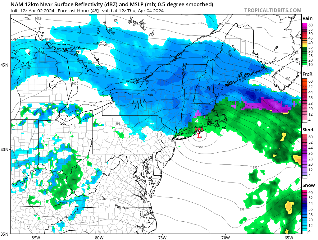
3 minutes ago, Allsnow said:
KDIX radar down until Wednesday
What a shame we can’t use it to track the rain/snow line in this one. It’ll be a nail biter!
-
 1
1
-
 1
1
-
-
2 hours ago, LibertyBell said:
wow, great memories! this was our "warmest" significant snowstorm....
Was nice to wake up to that morning, there was 6” of glue right down to the S Shore.
-
1
-
-
16 minutes ago, psv88 said:
Tomorrow looks like the worst weather day until next fall. Low 40s, wind and rain. Then we step up and out into spring
Don’t underestimate this extended fall with 10 days of winter’s ability to find new ways to keep us suffering.
-
2
-
1
-
-
A little surprised there’s no Flood Watch given the high water tables. Some models have 3”+ from this storm. Looks like another soaker.
-
2 minutes ago, MJO812 said:
LOL

I guess anything’s possible. It’s possible something sprang 1000 Loch Ness Monsters that will storm Battery Park tomorrow. That’s about as possible as seeing any snow from this storm.
-
1
-
-
1 minute ago, MJO812 said:
If only the low can bomb out further south and east.

It won’t in any way that will matter here. Embrace the puddles.
-
1
-
 1
1
-
-
3 hours ago, MJO812 said:
We should move NYC to upstate.
Take a day or two off and drive up there. Might be half decent around Hunter Mountain. Besides that nature is what it is.
-
1
-
-
6 minutes ago, psv88 said:
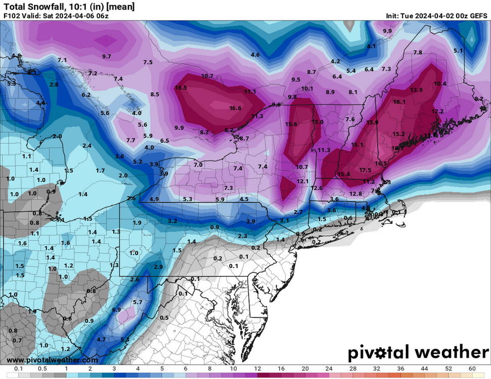
Thank god we are missing out on New England’s sleet storm. Nobody wants that in April
Along I-90 to Boston I'd definitely keep an eye on it still. ORH area anyway away from the coast and elevated could definitely still be majorly impacted. Our wet windy misery might just be a couple degrees colder if Boston ends up getting slammed.

April 2024
in New York City Metro
Posted
Hopefully if the big ACE season pans out there are lots of recurves. In a Nina it’s our one positive indicator for a snowy winter we can look forward to. But the tendency for the Bermuda high ridge to spike further north the last 5 summers or so might also mean storms are headed N at our latitude not NE which is a big danger if we have hurricanes near the Carolina coast.