

jm1220
-
Posts
24,530 -
Joined
-
Last visited
Content Type
Profiles
Blogs
Forums
American Weather
Media Demo
Store
Gallery
Posts posted by jm1220
-
-
1 minute ago, SnoSki14 said:
Big correction to hotter on GFS. 100+ now looks like a lock away from immediate coast.
Yep, 0z has the stronger westerly flow which drives the heat right to the coast. That will be key-if we get the onshore flow there's a strong cap on it getting higher than low 90s near the coast when water temps are still low 60s. Maybe even 80s if it's more of a SSE flow. But westerly downslope and we heat up big time everywhere.
-
 1
1
-
-
4 minutes ago, Wannabehippie said:
I wonder if we will get an old fashioned heat wave, 5+ days of 90+ temps, coming up this weekend in to next week.
GFS seems to be favoring southerly winds again at 18z with even an Ambrose Jet like setup in the afternoons. That would cap temps to mid 80s on the south shore if that, and the city/north shore to maybe low 90s. We're not getting high end heat in the city and east with strong southerly flow. The water temp off Jones Beach today is only 64. There would definitely be plenty of humidity but I highly doubt 95+ without westerly winds. NJ and Hudson Valley where seabreezes don't cap the heat is a different story.
-
1
-
-
Yep. Sun’s out here and first summer true sauna afternoon.
-
29 minutes ago, Sundog said:
The Euro and AI version are trending down slightly with max heights on Monday and Tuesday.
Here is an example for the AI Euro for Tuesday:
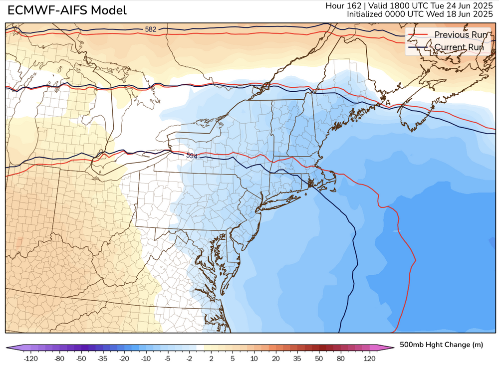
Starting to look like more run of the mill type heat for most especially the city and east. The eastern periphery of the ridge is prone to backdoor fronts and cloud/T-storms. Also looks like winds will try hard to veer onshore which heightens the humidity but would make it hard to reach 95. But if we have dewpoints well into the 70s with temps over 90 it’s still disgusting. Just not historic, more like our more typical FL type heat of late. Inland away from the seabreezes or backdoor intrusions can likely make it to 100.
-
1
-
-
Totally socked in here with fog. Haven’t seen the sun in 5 days. Truly wretched stretch.
-
3
-
-
Day #5 with rain.
-
6 minutes ago, MANDA said:
In my opinion this is going to be the bigger story. High HI readings. DP's in the upper 60's and low 70's along with 95-100 degree temperatures not pleasant. Lot's bed wetting going on with EXTREME max temperature forecasts. Dubious outcome on that.
I mean if it’s 94/78 that’s a 110 heat index which is quite dangerous. 104/68 is a 111 heat index.
-
16 minutes ago, Sundog said:
If you think that's funny the 12z GGEM just gave us a backdoor cold front for next Tuesday, the same day the Euro was giving us upper 100s yesterday:

If the ridge axis is to our west it makes it more likely the heat gets broken up by a backdoor front or T-storms. And there’s the southerly wind too that will try any day to factor in and cool it down. It’s just really tough to get these 5+ day big heatwaves especially the last 5 years or so.
-
1
-
-
Please move the political/bickering stuff somewhere else.
-
2
-
 1
1
-
 1
1
-
-
8 minutes ago, JustinRP37 said:
Talking to some people on the train today and everyone is super excited about a heatwave, even the people that hate the heat. I found that odd but I think everyone is just sick and tired of the constant dreary weather we have had. Constant October skies in May/June do mess with emotions.
If it really does go over 100 I could see real problems with the power grid. It’s heat we haven’t had in a few years and everyone’s been used to this Seattle weather. But there are plenty of ways it could still trend to run of the mill.
-
2
-
-
2 minutes ago, steve392 said:
61, dreary and.....raining..again
4 days with rain in a row.
-
1
-
-
8 minutes ago, TWCCraig said:
Too far out to know exacts but the latest GFS has more onshore flow than the Euro next week, so it has lower temps (mid to upper 90's) with higher humidity. Unfortunately it's been the theme of a lot of our heat waves in recent times
If the ridge gets too steep it’ll turn our winds southerly and the worst heat will overshoot our area again. Still plenty of time for that to happen.
-
3
-
-
3 minutes ago, nycwinter said:
these euro temps will not verify...
Well, you won’t be needing a blanket.
-
 3
3
-
-
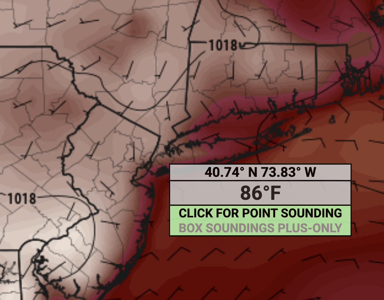
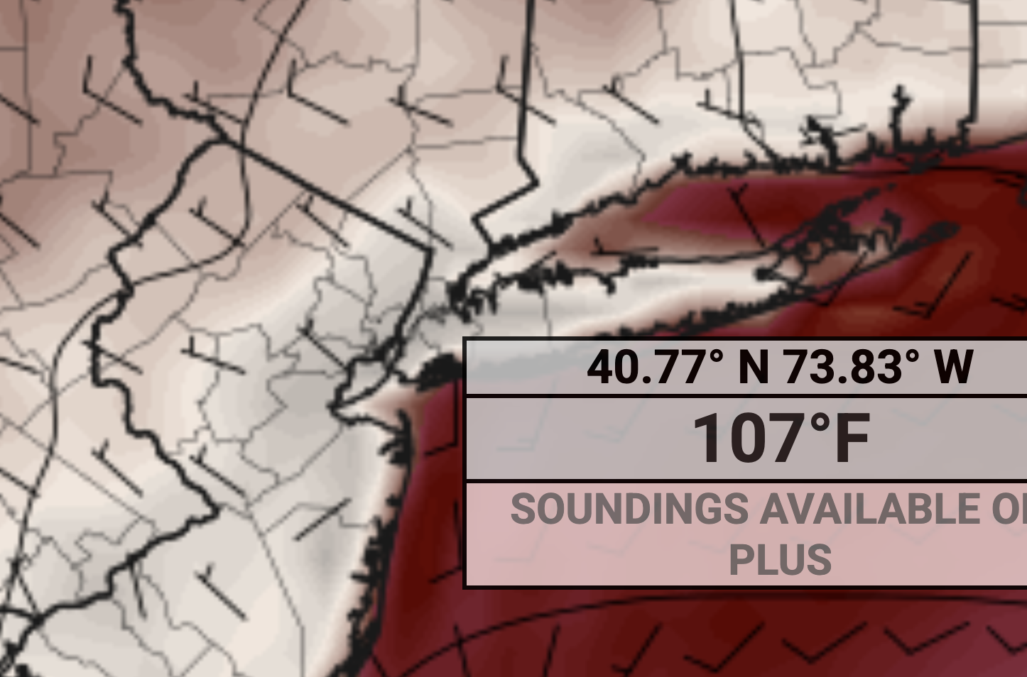
3 minutes ago, Sundog said:
Euro now has 107 degrees next Tuesday in NYC.
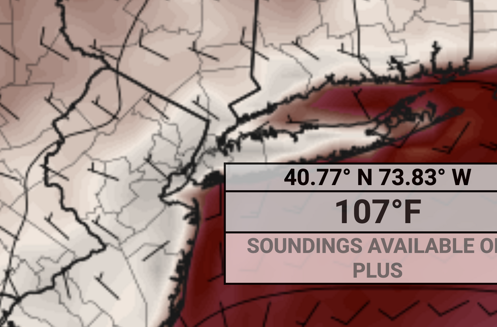
These WNW flow heat events are where we really roast and heights are absurdly high. We’ll see if that verifies (107 is likely too high but could definitely be 100+ if we get the downslope WNW flow) or it becomes our more typical southerly flow FL type heat.
-
2
-
-
40 minutes ago, LongBeachSurfFreak said:
Raining again. Froze at the beach today. Has to be the coldest day at the beach so late in the season I have had it in 27 years of life guarding. It’s that damp east wind.
Misery mist city.
-
 1
1
-
-
50 minutes ago, psv88 said:
What a miserable fucking day
Ain't that the truth.
-
3 minutes ago, LibertyBell said:
Yes that definitely looks like a NW flow event here, we could have the highest temperatures of the tristate area here!!
And maybe big storms. Sometimes we see derechos or big storm complexes on the periphery of these heat dome ridges.
-
1
-
-
In the winter because the overrunning would be better this would likely be heavy 1-2”/hour snow. We only get these in the summer now on weekends.

-
2
-
-
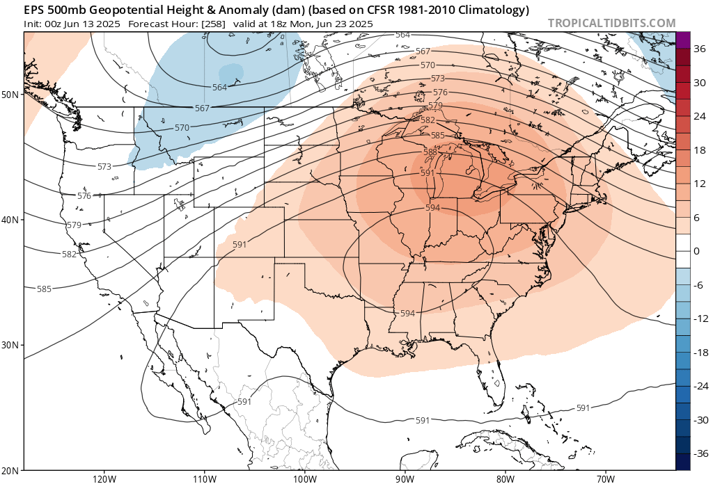
2 hours ago, bluewave said:
If the EPS is correct about that 594DM heat dome in around 10 days, then it would give us our first mid to upper 90s of the season.

That might be a good pattern to get MCS or derechos to track through from the Midwest. Looks like a ring of fire type pattern.
-
7 minutes ago, bluewave said:
Yeah, this is why I like living near the shoreline. I used to get a great sea breeze back on the South Shore of LI. Now I get the local sea breezes off the Long Island Sound.
Where I live now it seems like the worst of both worlds-we get the high humidity being somewhat close to the shore but it’s able to heat up a lot before the seabreeze eventually gets here by 4-5pm sometimes. Springs can be brutal in Long Beach but it’s nice to have low 80s there while the city, N Shore and inland are well into the 90s and sweltering. I was in TX a couple weeks ago and felt that kind of heat again-not a fan whatsoever of being soaked in sweat within 5 minutes being outside.
-
18 minutes ago, Brian5671 said:
Saturday starting to look drier N and E of the city as the precip gets pushed SW. But yeah temps will struggle to 70 Sat-Mon
High pressure/confluence to our NE, but the easterly wind might just mean tons of misery mist.
-
1 hour ago, LibertyBell said:
Some of these have to run warm. It’s not 96 in Huntington lol. 90 I can believe.
-
1
-
-
90 at the house.
-
1
-
-
Must be compressional heating. Upper 80s to 90 showing up in places like East Meadow and Valley Stream but the barrier islands are upper 70s. Seabreeze boundary looks like along the Southern State.
-
1
-

June 2025 discussion-obs: Summerlike
in New York City Metro
Posted
Same here. Feels disgusting.