

jm1220
-
Posts
24,530 -
Joined
-
Last visited
Content Type
Profiles
Blogs
Forums
American Weather
Media Demo
Store
Gallery
Posts posted by jm1220
-
-
Here's what I mean-it would be best if that 700 low was a bit further east, like offshore NJ. It's really being nitpicky at this point but this is why the heaviest amounts are over N NJ/E PA. Like I said if it happens this way I'll definitely sign on that dotted line.
.thumb.png.20ed1cb0cf17777e2a96d6519e510008.png)
-
 1
1
-
-
2 minutes ago, USCG RS said:
Euro just came in colder. Hm.
Yep it was a little better.

If the 700 low can track east just a little more it would be ideal for everyone but regardless I'll take the 15" it gives me before any changeover that would likely just be drizzle anyway in the dryslot.
-
Totals from the Euro. If anything looks a little better than last night.
.thumb.png.607dc69b081f80b81b95a06c7df3d551.png)
-
1
-
-
1 minute ago, TriPol said:
Can we get some Blizzard Warnings hoisted from Upton or no?
I could see it maybe for S Nassau and SW Suffolk. For the east end it's a question of the blizzard conditions lasting 3 hours or more due to mixing concerns.
-
15 minutes ago, mikem81 said:
Bottom line so far. Looks like heavist precip axis will be from NYC west but blizzard conditions and wind in the NYC and western LI area will make the snow hard to measure anyway so we can all just measure the drifts and get the same amounts.
Amped is winning out as expected but hopefully we can get a small shift east before start. NYC and LI will probably be warm enough for rain for a time but it will be when the heavy precip is over anyway, so most end up getting about the same amounts, but the highest would be NW where you also get the better ratios.
-
Just now, allgame830 said:
Do you think it will end quicker then expected or just lengthen the duration more?!?
Should just make it a longer event. I don't expect much accumulation today or anything but it'll set the stage. Models all have this lasting through Tue in some form.
-
1 minute ago, MJO812 said:
This storm is coming in earlier than modeled
These typically do.
-
Just now, Jebman said:
Since I've been down here, we have been fortunate not to get too much severe. It rains a LOT less here than in N VA. We see strong winds with some fronts in the cool season. But, no severe thunderstorms and no tornadoes and we generally never have to worry about hurricanes. They hit Houston, we are safely too far west.
Hopefully that picks up soon. In my time there there (Jan 2015-Nov 2016) was a F1 that went less than a mile from me, decent hail events (best I saw was a golf ball severe event, luckily for me my car was under a canopy), a 80 mph bow echo and numerous other severe/tornado warnings. Anything I experienced on LI severe wise beneath paled in comparison.
-
20 minutes ago, Jebman said:
Some of you are getting sleepy right now, You're draggin' baby.
No sleep. NONE! Stay the fook up! This is your first real major snowstorm in FIVE YEARS! Drink coffee as though you are on a winning streak in Craps at MGM National Harbor overnight! Take Uppers, meth, whatever it will take to keep you all awake!
WE ARE TALKIN SNOW HERE! This is NOT to be missed!
I got somethin' for y'all for the overnight! This, is when it gets good!
I miss the severe weather in Austin when I lived there. How's that been lately? I missed Juno and Jonas on Long Island which was rough enough for me to move back up.
")
-
Just now, Fozz said:
Yeah I'm skeptical that it gets that warm. Maybe around 33, but based on what I know of my climo I don't see it crapping out like that. At least not in my part of the state.
I would think you're in a decent place N of Providence for a while anyway. And I have to think it will end up a little less amped and more the way Miller B's typically turn out than the Euro has in the end.
-
1
-
-
Just now, Fozz said:
The Euro has a very warm coastal front messing up this storm for many of us in SNE, at least if you believe the surface temp projections. Up to 37 degrees at the height of the storm.
From my experience these front-enders don't just totally crap out like this even for you guys. It should cool the column enough at least for a few good hours. For the Cape and places like Plymouth sure I guess.
-
Just now, 40/70 Benchmark said:
It's too warm...
Right, I can see the layout of what it's showing with the min for the CT River valley etc but the amounts to me are just crazy low. I'd bet good money Northborough MA does better than me in a Miller B. Boston I could see the easterly flow and matured low killing after a time.
-
2 minutes ago, weathafella said:
Nice front thump, coastal taint inside 128 south if the pike, back to snow.
Yes, I'd have to think that's worth more than the 3" in Boston that map shows.
-
5 minutes ago, 40/70 Benchmark said:
That map is a perfect illustration of why my locale blows big ones.....never far enough north, but often too far north...but thank god its 7 degrees now w -4SD NAO
That has to be too conservative, the PivotalWX and other maps are better. Is this based on Kuchera ratios? (FWIW for my backyard it's not too off from those but also a little conservative, I'll certainly take either).
-
Just now, WxWatcher007 said:
Brutal for southern CT.
Yeah that wasn't fun. I think as the CCB pivoted I ended up with 3" or so. One I'd rather forget.
-
1 minute ago, Jt17 said:
6-12 inch storm watch for NYC is starting to seem a little silly - it's been at that for nearly 10 hours and I think plenty of data has come in for Upton to bump that figure up and set a winter storm warning.
I think they bump up somewhat and perhaps make blizzard warnings for southern Nassau/Suffolk/Twin forks.
-
1
-
-
16 minutes ago, MAG5035 said:
Another areawide Euro thrashing at 0z. I-81 corridor from Harrisburg to Scranton roughly being the bullseye, although most of eastern PA is 20"+ on Kuchera and Euro hasn't yet relinquished the snow completely all the way through hr 69.
I'll certainly take it although the dry slot makes it here along with some rain. Just 50 miles or so SE can make it even more awesome though lol.
-
3 minutes ago, TonyFeeN2 said:
That’s a good thing man this is going to be the biggest storm for a long time possibly top 3 of all time for NYC
No. If this comes together right it can perhaps make it to 20" but the top 3 are all over 2 feet.
-
1
-
 1
1
-
-
3 minutes ago, TonyFeeN2 said:
Do you guys really think the euro turns the city to rain? Seems improbably with how cold it is outside could be some freezing drizzle at the end
Verbatim it would but it would be as the heavy precip pivots away. The 10-1 ratio snow map has me at 14" but the precip total is about 1.7" liquid at the same point, so that would have 0.3" liquid as non snow. For the city the rain adds up to about 0.1". To me that means a very heavy initial snow thump followed by light rain/showers in the dry slot for a time.
-
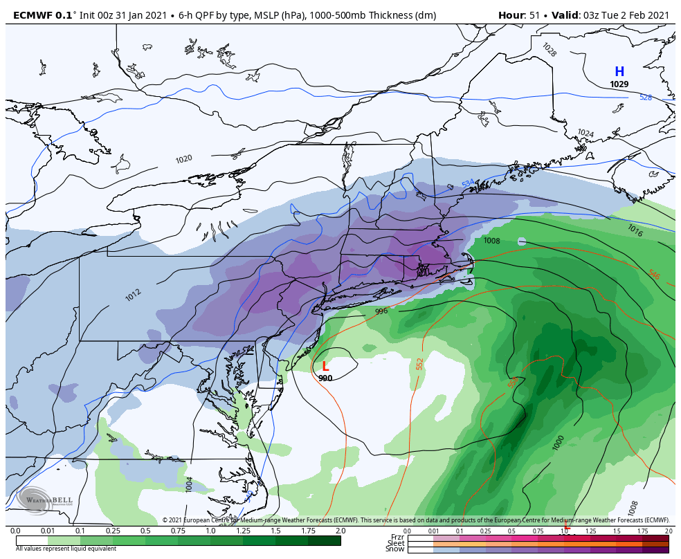
12z for comparison. I'm not seeing a big difference. Better snow for the NW crew. I guess more GGEM-like with the max in E PA?
.thumb.png.7bacaecae66516b01d0fa9f02becf74a.png)
-
-
Just now, USCG RS said:
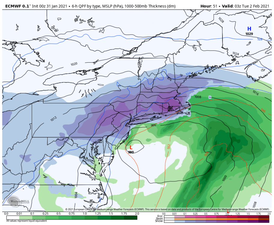
Looks about the same as 18z to me? At 3z Tue if we're all still snow outside of maybe Fire Island and the precip is tapering off I'd call that a win.
-
2
-
-
2 minutes ago, Wetbulbs88 said:
Oh man do you have a link for this? I used to have this exact radar for the NYC area until I got a new laptop and lost my bookmarks. Actually I think it was Philly because it gave a better vantage of what was to come.
-
1
-
 1
1
-
-
32 minutes ago, Greg g said:
Monster storm
:I remember the incredibly heavy snow band that formed like a fist (again I was living in TX then
 ) as Jonas came in in Jan 2016, something similar probably happens this time as the mid level moist easterly jet cranks up. Let's hope anyway.
.png.6a2149fd169ae1c2b974f7704c1ce159.png)
.png.2dcc53d780c1e4fdcb9918ca1a7d6abd.png)
.png.adb1e19423cbd2cda8233ff1819a6748.png)
.png.97db6290d75804982bc36f17c0e7df1c.png)
Major Nor'easter near blizzard (6"+ most of our area-best chance 20-30" north of I78 in ne PA, nw NJ, se NYS)-ice-rain-power outage NYC subforum late Sunday Jan 31-early Tue Feb 2.
in New York City Metro
Posted
Where you see the blues would be where the best lifting is so you'd want to be just NW of it I'd think. But before this there's an insane front end batch of heavy snow anyway which means that the overall difference may be just a few inches or so between NYC and west of town, and by this point on the map the low is starting to occlude which means the snow will become more spotty/banded.