

jm1220
-
Posts
22,982 -
Joined
-
Last visited
Content Type
Profiles
Blogs
Forums
American Weather
Media Demo
Store
Gallery
Posts posted by jm1220
-
-
25 minutes ago, canderson said:
Barbarians charging the gates.
-
32 minutes ago, MAG5035 said:
5.7" and moderate to heavy snow. 0.7" last hour. 30ºF
Hang on for as long as you can. You’re State College’s probably 45-60 minute warning this event.
-
14 minutes ago, Brasiluvsnow said:
I just saw that looks like he's freezing his cajones off
It’ll be especially infuriating when it’s 13 degrees and sleeting there overnight. It’ll be a good event there, probably make it to double digits but we’d be pissed as a sub forum if we were in Albany.
-
 2
2
-
-
Rain in Long Beach. At the beginning there was some really light snow/graupel/whatever.
-
Just now, MAG5035 said:
Up to 5", it's dumping snow. Almost an inch in the last 30 min.
Awesome!! Good for you guys. Here’s to hopefully an overperformer. Outside my window right now, rain.

-
3 minutes ago, canderson said:
Man CTP has really shifted the zr forecast NW. <.1” for MDT but up to .25” for State College.
Models are showing temps getting up to 33-34 as the 850 line zooms overhead there. Maybe it’s a little too warm but I also don’t remember many ice storms in State College. I remember tons of sleet and numerous 33 degree rains.
-
1 minute ago, NJwx85 said:
Ignore surface temperature trends at your own peril. It might not matter for LI and the city but it does for anyone N&W of where the GSP meets the Thruway.
I'm still definitely thinking there'll be a zone of nasty icing around I-287 and also maybe I-84 corridor. The cold surface air is pretty stout and while mid level warmth is usually undermodeled, surface cold is usually undermodeled too. Hopefully it's more sleet and less ZR.
-
1
-
-
Just now, weatherpruf said:
I don't know people I talked to casually in the bank etc this morning all seemed to know it was a bust down our way. But there is a state of emergency on, I guess for icing in northern parts of the state.
The supermarkets were still crazy today down here. A lot of cautious folks after the November surprise snow. But this is one I'm pretty confident will be a washout by me.
-
Just now, Brian5671 said:
18z NAM supports the flood watch-wow!

The frozen ground will worsen the flood threat down here since it won't soak in, and it's a dynamic system that could dump 2"+ rain. The frontal passage could be pretty wicked with thunder. It'll still be a nasty storm despite the cold and snow not happening down here. It's becoming primarily far upstate NY and NNE for the big snow. The SW flow out ahead of this just killed it for many.
-
Good call for those who were saying this would trend north at the end. SWFEs (which this pretty much is) usually do. Even Albany's getting cut back decently on snow amounts and State College is looking like it'll be a low-end warning level event rather than the 14-15" being called yesterday. We may still have the lead on Boston for seasonal snow after this. Might just be wall-to-wall rain for most on Long Island and NYC. Could even have thunder as the cold front comes east-looks like a pretty nasty line with that.
Further inland especially around I-287 looks icy still due to the cold drain and NW of there still looks like a good thumping for a while before ice.
Two bad trends: the overrunning shooting over us so we waste the cold we currently have and the low trending further amped.
-
1
-
-
7 minutes ago, LongBeachSurfFreak said:
36 with an east wind on the bay in South Wantagh. This ones DOA here.
still expecting a couple inches and some sleet on the far UWS. As others have said we will wet bulb during the thump. It’s all about now casting where the precip itself sets up. As of now it looks like it starts snowing north of the city before south so that in itself hurts
Yup. I'll consider anything more than covering the ground a win on the south shore. This one is completely trending the wrong direction. The initial overrunning overshooting us to the north is another issue. There may not be much cold left by the time snow/whatever starts.
-
1
-
-
2 minutes ago, sussexcountyobs said:
I'm a little confused with the dewpoint temp. If its dropping, does that mean colder air is draining in, or just drier air or both?
If the dewpoint is dropping, it means temps will cool off more when the precip arrives. The air cools as it becomes saturated enough for precip to reach the ground. The drier the air, the more the air cools.
-
 1
1
-
-
CTP is making their call for more snow south of I-80 to the Turnpike and I definitely respect that. Unfortunately the models keep trending warmer and even the NAM now surges warm air north enough to make a good portion of the precip non-snow up to even Clearfield on ENE. Some of the precip on the most recent NAM may even be rain in UNV. Hopefully the snow is good for the initial few hours, but I'm thinking sleet/ZR/rain is knocking down accums for almost everyone in this subforum. I'd go 6-10" along I-80 including IPT and UNV, 4-7" in Altoona (maybe not AOO which is south of town), 3-5" in Harrisburg and along I-76. The foot or higher totals may be in the northern third of the state and north of IPT.
-
58 minutes ago, SnowGoose69 said:
The problem is most guidance now pushes the majority of it north of the area until 03-04Z. By then almost everyone would be too warm for anything but sleet freezing rain or rain
The warm push in general looks stronger which I guess also forces the initial overrunning to shoot over most of us too.
-
Yeeesh at the Euro. Hard to discount the warmer models tonight. Maybe an inch of slush to soaking rain on the south shore where I'll be this weekend, to an arctic freeze on Monday. This storm definitely looks like a sledgehammer climo reminder. Hopefully my old stomping grounds in State College do well for a change and the sleet can be held off.
-
5 minutes ago, MAG5035 said:
Yea here in Altoona it could go either way. 6-8" is probably still a good bet and if there's not a lot of mixing then a foot or so is certainly doable. I think UNV gets to 10". I had a post earlier today mentioning if that happened I believe would be the first winter they've had 2 or more 10"+ single events since 95-96. We got whacked by the November storm in this region under similar circumstances. I think the original warning was for like 4-7 and I had about 9 inches before it even mixed (on the way to 10.5") and State College had almost a foot. The damage was done on the front end of that one and it just poured snow for a few hours in the afternoon. This one is similar but stronger, more moisture laden and perhaps a bit further north. November's storm didn't have a closed 850 low and this one does which with the track of that into SW PA is the primary sticking point with this system. On the other hand we're deep into January and in the coldest stretch climo wise, there's a significant arctic air mass to the north that while not being fully tapped will likely anchor some CAD. I just don't think we're raining nearly to Williamsport on the GFS's track. (maybe if the super amped RGEM and HRDPS had its way). I don't think I've ever seen CTP bet the house on totals like this given uncertainty, esp in between the turnpike and I-80. It's going to be an interesting day tomorrow.
At least maybe I can watch a whiteout on the PSU webcams as I get ready for my slushy inch to rain in my backyard.

Hopefully it does work out there. The Nov event was definitely a big overperformer. The biggest event I saw in State College was probably 2/14/07 which was supposed to be 18-20" but ended up 11" due to the same warm air aloft and too far west 850 low. I lived there during a really boring period, hopefully it's finally turning back to snowier in central PA.
-
5 minutes ago, Wmsptwx said:
Why even make that call then, they should know climo better than anyone.
It’s a really tough call for the middle third of the state. Wouldn’t want their job right now. The models edging a little warmer tonight so far would worry me somewhat for totals over a foot in that area. We’ll see if they adjust in the next update.
-
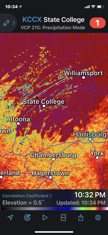
28 minutes ago, Blizzard of 93 said:
Here is the latest from CTP as of 1034pm
They are Not backing down!

I'd love for that to verify for you guys who live south of I-80, but places like UNV and definitely AOO are living on the edge with the warm layer aloft for a time. Models are showing a real pounding for a good few hours on the front end which can hopefully keep the heavy sleet to maybe Rt 22 and south, but if the warmer models are right, it would cut back quite a bit up to I-80 and even up to IPT. I could see the 14-15" being predicted for State College if the heavy snow comes in fast like a wall and the warmth can be held at bay, but I can also see it being 7-9" of quicksand from a surging warm layer. I'm really not seeing how Harrisburg gets 8". Hopefully I'm wrong and it's an overproducer, but I've gotten burned a few times on these storms when I lived in State College in the mid-late 2000s.
-
23 minutes ago, pawatch said:
They have been pretty steadfast for the last couple days.
Down by Harrisburg and the Turnpike, it's more bullish than I'd go. I'd shave a few inches off that. You really need a NAM come in like a wall solution that holds off the warmth aloft as long as possible. And up further north it's also risky. UNV getting 14" is if they stay about all snow. It could easily be 7-10" if the warm air aloft wins out and the sleet line races north. This isn't an easy forecast from I-80 south. I lived in State College long enough to see promising events like these turn to an icy mess at the last minute because of warmer air aloft than expected. A day before the 2/14/07 event, 18" of snow was expected there and it ended up with 10-11" icy gunk.
-
1
-
-
Will be interesting to see how far north the sleet makes it, enough to cut into accums. The 850 low track makes me think it gets to State College and maybe Williamsport for a time. The WAA aloft is often undermodeled. Should be a really nice event for all north of the Turnpike though. Enjoy.
-
Wasn't enthused by this one near the coast yesterday and aren't now. My call is the south shore getting up to a couple of inches before a washout, the north shore and northern NYC maybe a few inches and sleet before rain, and 6"+ starting west of the Tappan Zee Bridge, north of I-80 in NJ and inland CT. There it snows for a while before sleet and then icing. The signs are pointing fairly strongly towards the typical N/W favored storm that washes away any snow from the city and east/south. Perhaps a nasty flash freeze areawide though as it exits and drops the arctic hammer.
-
8 minutes ago, tim said:
...my estimated observation @7am sunday morning...37* with heavy rain with <1" of snow OTG..
not expecting much out here.

Same for me. I'll be in Long Beach this weekend where it'll probably be a quick inch or two over to rain. Where I am now may be up to a few inches and some sleet before going to rain, but this isn't the type of storm that does well on the coastal plain. It's your classic North and West storm.
-
2
-
-
26 minutes ago, Stormlover74 said:
I think by 72 hours out mixing was starting to show up because of the 850 low being in ohio. Even then we got far less snow than forecast as the change to sleet was fairly quickly
A good rule of thumb is wherever the 850 low tracks and SE of it won't stay snow for too long. In that area the mid levels are torching on southerly flow. The stronger the 850 low, the stronger the WAA. For days, models showed 20+ inches of snow for much of PA that storm despite a bad track for the mid level lows and a strong primary. I remember living in State College then and having 6" or so snow and then tons of sleet. There was light snow during the day, by dusk finally mod/heavy snow when the mix line started surging north, then the telltale massive aggregated flakes that mean warm air is partly melting the flakes aloft, then ping ping minutes later. Surface temps the whole time were in the teens. The backlash was good there because the coastal low finally took over, moisture was still around and cold mid level air came back. The end result was 11" or so of gunk that froze into cement.
-
2
-
-
I could see the larger system being a decent overrunning producer given the high ahead of it, but the high is pulling away and the flow is backing around to the SW too quickly, allowing a track too far west as of now and warm air to roar in aloft. Maybe the pattern out west could be a little more progressive and nudge it east, the trough could amp a little less, or the resistance in Canada could get a little tougher. But there's no help from the NAO, so nothing to force it to amplify less and surge warm air in with a track too far west. The SW flow aloft is also killer for a major snow event near where the low tracks and maybe even a good bit inland where there could be a zone of nasty icing and sleet. If there's a strong primary surging into OH or PA, I don't see much to force an early transfer to cut the warm air aloft off. You really want the trough to amplify less and track the low further southeast. There's still time for some adjustment there.
But the initial overrunning should be good for a few inches hopefully.
Central PA - Jan/Feb 2019 Obs and Discussion
in Upstate New York/Pennsylvania
Posted
Probably not a great storm if you're west of the Susq. and east of the Allegheny crest. This is shaping up to be a "Central PA middle finger" storm that skips over the central part of the state and redevelops for E PA. Hopefully it can at least be an inch or two in central areas.