

jm1220
-
Posts
24,534 -
Joined
-
Last visited
Content Type
Profiles
Blogs
Forums
American Weather
Media Demo
Store
Gallery
Posts posted by jm1220
-
-
Light to moderate snow in Long Beach, coating on non paved surfaces.
-
5 minutes ago, NorthShoreWx said:
When did you return to LB?
Just here for the weekend.
-
14 minutes ago, psv88 said:
30/25 in nw Suffolk
38 in Long Beach still. I miss Huntington.

Not much difference in snow that fell on Monday but a pretty big negative difference in snow left from there to here driving down last night.
-
 1
1
-
-
Consider anything more than a good snowpack builder a bonus. Southern stream systems typically end up wetter/north in the end. Hopefully this follows that pattern. In Long Beach this weekend-decent chance at 6+.
-
1
-
-
I’m not too concerned about the Ukmet. There might not be too many that get over 6” but should still be a decent snow pack reinforcer.
-
1
-
-
6 minutes ago, kat5hurricane said:
It's the same story pretty much every storm close to the event, Nam too wet and GFS too dry.
As usual, take a blend of the models and you have a 3-6 inch type deal.
GFS actually got a little better from 6z. RGEM got much drier, hopefully it just had an off run.
-
My guess for this would be 5-8” (maybe more like 5-6”) for most with 3-5” far north and west like in Orange and Sussex County. NAM as usual is probably too wet but RGEM hopefully too dry. Should be a nice moderate type event. I saw a reference to 2/7/03 elsewhere and that’s probably a decent analog.
-
3 minutes ago, li_wx88 said:
Very surprised that Upton and the local news guys are posting some of the totals that they are given the drier runs especially on the 6z GFS and NAM.
RGEM was wetter.
-
Oh and how the SREFs set the scene. They should be annihilated in a supernova.
-
5
-
-
2 hours ago, HVSnowLover said:
Rain wasn’t much today but snowpack actually took a decent hit from the sun and temperature.
Long Beach had at least 12” but numerous grassy patches here. More left over in Huntington before I drove down today.
-
Just now, ORH_wxman said:
RPM, Where I live, not so much as a flake.
Too bad so sad, how much more abuse can I take.
15” fell at my place on Monday.
Gotta make 8” more happen on Super Bowl Sunday!
-
4 minutes ago, SI Mailman said:
checked the soundings, that rain that shows on pivotal is actually snow, so don't freak out.
The precip panels on Pivotal can be funky sometimes. A few times it showed me as sleet when the soundings were all below freezing. Look at the 700/850 low tracks before any of the panels. I guess I can buy the initial light stuff being rain if it’s light and temp is 36 or something
-
1
-
-
12 minutes ago, Rjay said:
Not one flake for you and I on the mean lol
Last event it gave me 5-6” and a ton of rain on a few of the runs and we know lol.
-
 1
1
-
-
2 minutes ago, Rjay said:
The SREF is ugly for areas i95 and south and east.
I’m not losing sleep over it given how over overamped it usually is.
-
Just now, MJO812 said:
Its also the most amped model we have right now
Hopefully this is as amped as it gets and others don't make a big leap NW. 3k NAM was even more amped and brings a dryslot in. This winter you can never rule it out.
-
1
-
-
NAM is still good for the coast but you definitely don't want it amped anymore without it becoming an inland focused event and a chunk of it being rain or a dryslot from the city east. The mid level lows all trended about 50 miles NW from last run.
-
Highs well above expectations again and the sun is out. Pretty mild out now with temps in the upper 40s. Lots of melting this afternoon.
-
19 minutes ago, SnowGoose69 said:
Yeah I think so. I don’t see it coming tremendously west. I can argue for it coming west but it’s going to be hard to get this thing tucked in I think
I think we’re setting the goal posts. Euro might be the east goal post and RGEM west? It probably ends up closer to the west goal post but I’d think this is fast moving enough and sampled well enough by now for no more major changes.
-
1
-
-
Euro decently better but still a little east of the other guidance so not as much west of NYC especially.
-
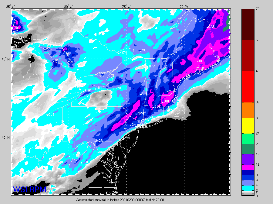
For OKX and HPN
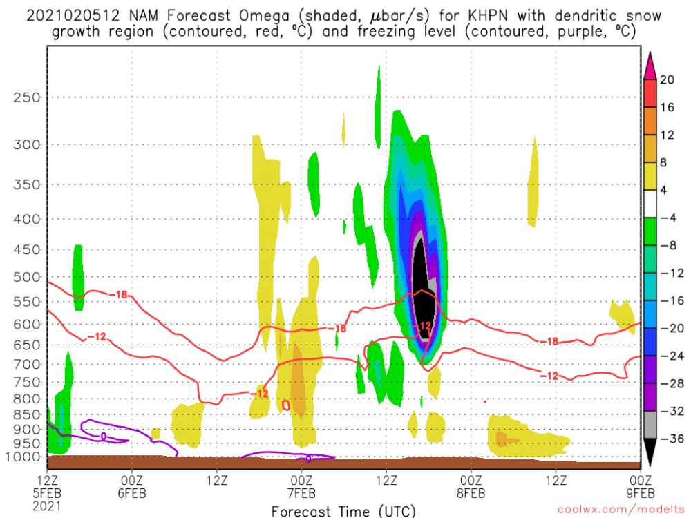
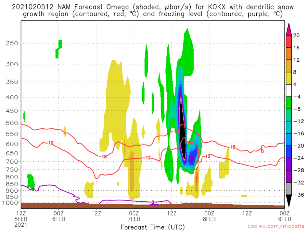
-
2
-
 1
1
-
-
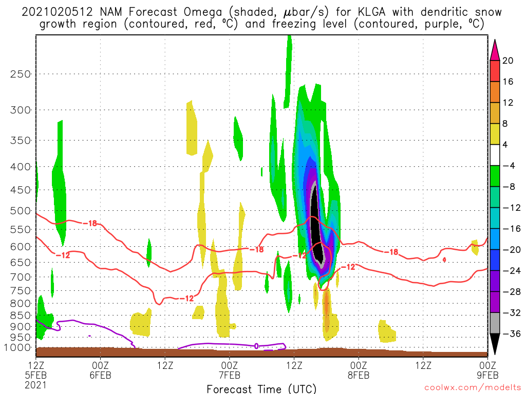
If this is right, short lived but very heavy rates and lift squarely in the -12 to -18C part pf the column. For LGA:

-
1
-
-
2 minutes ago, bluewave said:
It will be interesting to see if we can get thunder snow with this one.

That would be insane on the level of the last storm in terms of rates, probably 2-3”/hr. Of course moving much faster but a very fun 6-8 hours.
-
2
-
-
Just now, MJO812 said:
Mike Woods says 1-3 inches for NYC with rain
Smh
Most TV Mets are just lousy. They were way underdone east of the city on the last storm until the morning of and even then we were on the top end of the ranges if not higher. Upton was generally overdone but was better. There are some exceptions like Craig Allen but not many. I’m sure by 5pm those will be upped and we might be under a watch anyway.
-
5 minutes ago, wizard021 said:
Ratios look higher than 1:10 . Strong lifting with 700 mb temps minus 10. 1 inch qpf would squeeze out 12 inch of snow not 10.
 Very
Very
In this case the 700 low is taking a great track for coastal areas. I haven’t looked at maps/soundings for where the max lift is but if it’s in the -12 to -18c layer that’s the best for high ratios.
-
1
-


Obs and nowcast Super Bowl Sunday 4A-6P Feb 7, 2021
in New York City Metro
Posted
Here it’s been very light stuck under the subsidence. Looks like some heavier snow about to move in so hopefully some better accumulating.