

jm1220
-
Posts
24,534 -
Joined
-
Last visited
Content Type
Profiles
Blogs
Forums
American Weather
Media Demo
Store
Gallery
Posts posted by jm1220
-
-
Just now, chrisNJ said:
The banding watching will be fun. Like in December when I watched the biblical band in NC PA head and pivot to the BGM area.
Not sure if this will be the same with the crazy deform band. This seems to be much more based on the initial warm air advection snow then the low occludes/matures which would stop the consistent heavy snow banding. But maybe, who knows.
-
6 minutes ago, Hoth said:
Or the late Feb 2010 storm that nailed you guys.
That one was something alright. I used to live 25 miles SE of NYC and left for Manhattan that day in a driving rain and then it flipped completely to snow midway through Queens. Manhattan was a whiteout. When I came back I followed the R/S line as it pivoted east and got home literally as it changed to snow. I ended up with 10" or so and Central Park 22". Winds were insane too, well over 60mph. It was northern stream driven but had a good tropical moisture feed as well.
-
 1
1
-
-
Just now, HVSnowLover said:
Who’s headed to Allentown?
-
Not sure how many follow the ICON or how good it is but it looked really tucked with rain at some point past NYC.
-
Just now, HVSnowLover said:
That’s on 10:1 ratios I’d love to see the kuchera maps on rgem for kicks and giggles since I’m sure ratios will be higher in PA than 10:1

-
 2
2
-
 1
1
-
-
2 minutes ago, Allsnow said:
Boston 1 NYC 20 on the RGEM
RGEM probably isn't done correcting. Most models at least give them 5-6" or so on the front end burst when it reaches them. The easterly flow and maturing low is a pitfall for them this time though. Miller B's don't normally max out on this area (at least west of Suffolk County). Would be sad and somewhat hilarious if NYC catches up to them in seasonal snow. They have 23" now and NYC has 10.6.
-
2 minutes ago, SnowGoose69 said:
This continues to look like 1983 in a 2021 climate. The evolution of the storm itself isn’t really close to 83 at all but that easterly inflow jet is.
I know the NAM's the NAM but that 700mb map is absolutely classic to wreck 90-95% of us-tremendous lift and tons of moisture on that easterly jet. And it isn't moving all that fast like these front end bursts often do such as 12/17's.
-
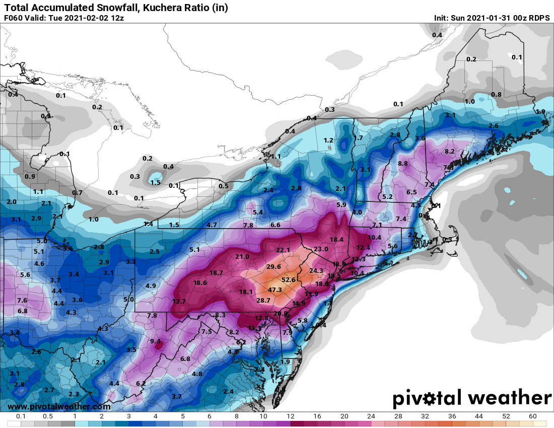
And it's obviously way overdone with that heavy snow area in E PA. It'll be a great place to be but there won't be 47" in Allentown.

It's typical in miller Bs that the development is a little delayed in the end and more progressive. Usually that burns NYC and benefits Boston but this time it's exactly what we need.
-
1
-
-
1 minute ago, USCG RS said:
LI may be lining up for a heck of a hit...
I may need to get some crow to cook.
I might run out of shoes after I have to eat them all.

-
1
-
-
Way better than the last 2 RGEM runs. DC/Baltimore won't be happy but I can't think of a miller B like this which jackpotted that region or any miller B for that matter.
.thumb.png.eb1b8cfa80b90984c06071b558b00086.png)
-
2
-
2
-
-
Just now, MJO812 said:
Wow still snowing

Good, an improvement from that model was all I needed to see. Would be best if the 700mb low ticked east a little more but there's time for that.
-
1
-
-
Just now, hudsonvalley21 said:
Thru 60 hrs with 24 more to go.
Yep, as snowgoose said there'll be snow showers and some bands around that could add 1-2" maybe if lucky on Tue.
-
1 minute ago, HVSnowLover said:
Definitely came west but it’s minor difference from 18z
Not tremendously, I'd say it's noise. Hopefully we're in consensus time where the tucked models can come east/develop a bit later and the models like NAM tick west a little.
-
Just now, Metsfan said:
Looking for a good sounding website. I know psu has changed.
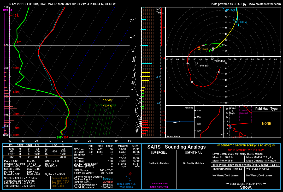
PivotalWeather is pretty good. This is the sounding for my location at 21z Mon on the 0z NAM.

-
Just now, SnoSki14 said:
Nam did shift a bit further west from the last run.
Even the RGEM and tucked models going east a little would be a great outcome for all of us other than the twin forks. The GFSv16 consistency is encouraging too, I don't see both of these flopping totally on their face this close in. The old GFS though I'm essentially disregarding.
-
1 minute ago, Torch said:
Wasn’t it the nam in 2016 produced the most accurate predictions 24 hrs. Prior to the onset.
I think so but Jan 2016 was a different kind of storm than this one. We're in the range now where hopefully the NAM has a clue though. It's not 72-84 hours out anymore where it's usually discounted. Not sure how useful these are yet but the SREFs seemed pretty warm at 21z but sometimes the NMM/ARW models they run on are too amped.
-
Hopefully the RGEM in 30min ticks east again, if so the NAM may be onto something here.
-
1
-
-
-
Just now, Gravity Wave said:
NAM is east of the other models with the low, good news for NYC and LI.
It's awesome but for now have to treat it as wx porn unless the foreign models that have it more tucked jump on.
-
NAM's a monster/crippler again. This is my favorite panel. This sits over NYC/Long Island for several hours. That would be 3"/hr snow in that band.
.thumb.png.5f8beec4a3dce0f5783d053bde93e67b.png)
-
1
-
-
15 minutes ago, eduggs said:
I think the big totals are possible somewhere. We have the right ingredients. The problem is the jackpot zones aren't usually forecastable in advance of nowcasting time.
Oh definitely, I can see some people getting 20". I just don't think it'll be the city in this setup. It'll be a place maybe near I-84 where ratios are good and there's plenty of moisture. snywx, sussexcountyobs, ForestHillWx, where you are will be some of the best spots.
-
1
-
-
3 minutes ago, Nibor said:
Does one season a shoe with rock salt?

Yes and pan-seared 5 minutes on each side.
-
1
-
-
Just now, eduggs said:
Ballsy going 15" for Danbury
And ~1 ft City wide isn't exactly going low.
For the City I'd say 9-12" with 9" in the Rockaways/JFK and 12" in the Bronx. That's about what consensus is. These insane model outputs aren't happening. I'd be thrilled but I'll eat my shoe if I get the 24" the new GFS shows.
-
5 minutes ago, Allsnow said:
Nyc and Phl might do better then Boston on a Miller b crazy
The strong east flow's a blessing and curse. Longitude west actually helps us this time. But we don't want a low stalling out just off Atlantic City or it's our turn sooner or later too.
.png.9e0865f491adf83d41e1aca8bfe35c79.png)
.png.1e1c386a351445424d11a6bea5642c85.png)
.png.284b8d8924eafb97fadca8dd01410b40.png)
Central PA - Jan 31 to Feb 2 Winter Storm
in Upstate New York/Pennsylvania
Posted
Yup, that is about as perfect an outcome as could possibly happen in my backyard. Good for you guys too since the moderate to heavy snow lingers as the coastal low develops on the easterly flow. RGEM would be the best case obviously but I have to think it keeps trending east with the heaviest snow. Miller B redevelopments very rarely bury eastern PA and not places nearer to the coast, actually I can't think of any that have done that. I'd say this is a very solid 8-12" for all you guys, maybe less for people like 2001kx in Clearfield with 12"+ most likely near I-81 especially around Harrisburg.