

jm1220
-
Posts
22,998 -
Joined
-
Last visited
Content Type
Profiles
Blogs
Forums
American Weather
Media Demo
Store
Gallery
Posts posted by jm1220
-
-
8 minutes ago, LibertyBell said:
Not all of Long Island is getting "blitzed" though, here it's a nice light to moderate snow. We'll get to 4" and there's an outside shot of 6"
I wouldn't call it "bad luck" I just think it's the natural evolution of the storm.
I don't believe in "luck" as you probably know.
I’ll probably end with 7-8”. Dumping here again but should be light from here on out.
-
 4
4
-
-
Just measured 6” or a little under on my deck.
-
1
-
-
About 3” here now. Ripping.
-
3
-
-
About 1.5" on my deck. Coming down at a good clip.
-
2
-
-
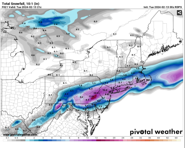
27 minutes ago, snywx said:
6.5" otg now
Heavy snow continues
That north fronto band never fails.
-
3
-
-
3 minutes ago, Allsnow said:
Positive snow depth change on the HRRR

Positive for sure!
-
2
-
-
1 minute ago, winterwx21 said:
It's a little south of its 12z run with a sharp cutoff for NW New Jersey, but very nice for our area.
Now time for the short range/hi-res models. South trend seems to have stopped on those too and maybe a slight bump back N.
-
1 minute ago, Franklin0529 said:
That band is like 2-3" per hr stuff. If this thing was slower would drop 2ft
Yeah that would be a massacre for 4-5 hours.
-
1
-
-
GFS big dynamic banding again with the mid level lows evolving in the perfect spot. Awesome.
-
4
-
-
3 minutes ago, USCG RS said:
Well, flurries tomorrow it is.

If ya know, ya know.
Maybe this Sub Forum needs to pay for him to go on vacation in February more often...
Unfortunately, without the rates, LI is in a very different spot. All depends on how quickly this deepens. Lack of blocking may be our death knell here after all, but, lets see.
Ehh. We've had washouts and the January few inches, whatever this has will be infinitely better.
-
1
-
-
Just now, psv88 said:
We are in the sweet spot for this one. Take a drive to west hills park tomorrow. It’s beautiful in the snow.
Yup!
-
Just now, donsutherland1 said:
Philly might still squeeze out an inch or two.
Would definitely still be worth interest there. Trenton area especially. But further south also means weaker dynamics.
-
1
-
-
3 minutes ago, donsutherland1 said:
HREF at 2/13 13z:
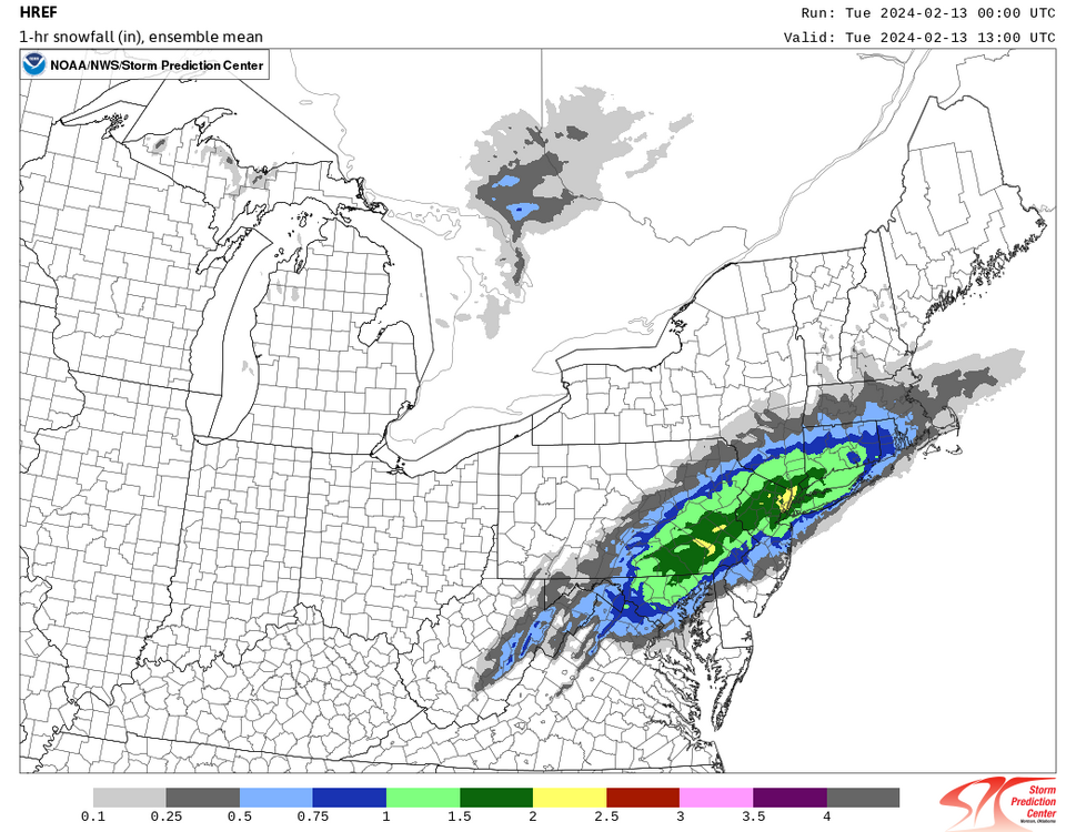
Trenton to Philly should be excited too. Good evolution for them. Maybe Baltimore?
-
2
-
-
3 minutes ago, brooklynwx99 said:
more than decent, no? nice to see that it held. very consistent
Seemed like maybe a little lousier dynamics. Anyway we'll see what happens. Still excited for this along I-80-NYC-LI.
-
1 minute ago, EastonSN+ said:
Did it bump north a bit
Didn't really change. I'm just comparing vs the recent HRRR trends, and that's not bad either, maybe bumped back N a bit.
-
2
-
-
RGEM still decent.
-
3
-
-
1 minute ago, Allsnow said:
Good thing you kept the snow stuff in the garage. This is a nyc storm now
Philly jackpot at this rate lol.
-
Just now, Brian5671 said:

You're probably still good. But wow at the trends today. LOL
-
1 minute ago, Snowguy66 said:
Be precise, when you say much weaker. I am about to stop looking at the freaking models with this ping-pong back-and-forth crap
.There's definitely a weaker trend on the models so far but still good for a significant event around the city. I-84 corridor is sweating though. South also means weaker dynamics.
-
1
-
-
6 minutes ago, jayyy said:
The mid Atlantic (Maryland / DC area in particular) is seeing their third storm of the year trend in their direction inside of 24 hours. Insane.I'm definitely interested for Philly to Trenton and west on the Penn Turnpike to Harrisburg. DC/Baltimore probably need more help than possible this late.
-
1
-
-
1 minute ago, HVSnowLover said:
I mean in fairness this has been one of the most extreme last minute trends I can remember (especially south).
Almost like a reverse Juno 2015 but even that had more agreement it wouldn't be special in NYC besides the Euro/NAM until the end. But yeah, there'll be an uproar in much of New England if these lamer solutions happen.
-
5 minutes ago, Brian5671 said:
whole state is closed here tomorrow-town/city offices schools you name it--north of 84 may have close to nothing.
I think you'll be okay but yup-tough call north of you. These do like to drive a fronto band pretty far north but that HRRR run sucked.
-
Just now, MANDA said:
Laughable if true.
Yup. Yikes.
-
Wow. Schools in Boston are closed for maybe 2-3" there.


2/13 Significant/Major Winter Storm Discussion & Observations
in New York City Metro
Posted
I’m at about 7”. Nice final burst coming in-hopefully I can get to 8” but will probably be a little shy of it.