

jm1220
-
Posts
22,998 -
Joined
-
Last visited
Content Type
Profiles
Blogs
Forums
American Weather
Media Demo
Store
Gallery
Posts posted by jm1220
-
-
Just now, WestBabylonWeather said:
11” of heavy wet snow at jfk. My call flame me
If that happens there's at least 15" IMBY. I'll gladly take.
-
1 minute ago, Wxoutlooksblog said:
For my neck of the woods, western LI and Queens it's I think going to snow heavily from 7AM-Noon then end pretty quickly. I cannot really see anyone around me getting much more than 5" with an isolated 6" here and there. It will look great coming down, silver dollar flakes, but it will have trouble at first sticking at all to the pavement. Still, the pavement will get a few inches. Now if there were more blocking and the storm slowed down, it could be twice as much. But I don't see that happening.
WX/PT
For the usual warm spots that are hard to accumulate I definitely agree. But in the places that are a little colder outside the city or even Bayside/Douglaston I can see 10" in some places-looks like it will really pound for a few hours. If this banding really happens it can happen in 4-5 hours at 1-3"/hour. I'm glad to see the Euro got a little better and HRRR/RAP are primed. GFS was annihilation from 7am to noon.
-
1 minute ago, Allsnow said:
Wish we had a better airmass but it will be the biggest storm since January 22
Not ideal for sure but we can do fine with a dynamic enough system-March 2018 etc. Midtown, the immediate south shore and usual warmer spots might have some issues but heavy snow will drop most of us to 32-33 quick.
-
 1
1
-
-
3 minutes ago, bluewave said:
I am glad that we finally got a day 8 EPS mean storm track to drop south from Boston to the Delmarva instead of the other way around like we have been seeing in recent years.


We pulled the rabbit out of the hat for once. I’m legit excited for this one. From 7am to noon for just about all of us will be awesome. The mid level evolution looks about as good for NYC/I-80/LI as it gets. And further north should be okay too since fronto banding with better ratios usually extends pretty far north in these.
-
2
-
-
This reminds me a little of 3/22/18 and how it went to town as it headed ENE. I doubt there'll be 18" on parts of LI like that storm had but many can end with double digits. The banding signatures and mid level evolution along with the abundant moisture to work with will mean 2-3"/hr. But it'll be hauling which will limit the amounts somewhat.
-
20 minutes ago, USCG RS said:
I would agree with this. The key -IMO- is the phase. If it is cleaner and the storm explodes, then we have a game on system with a substantial hit for the Tri-State. IF it develops a bit late, then C/E LI have a moderate to significant hit and the rest of the Tri-State is a left behind.
If the GFS is right and the mid level lows/banding go to town as it heads east off NJ, it'll be an insane few hours. Too bad there's nothing to slow the storm down but I'm liking this more and more. Glad to have been proven wrong on the N trend.
-
2
-
-
GFS is an absolute crushing from about dawn through noon. Wow.
-
5
-
-
5 minutes ago, HVSnowLover said:
LI is in a good spot. NYC probably in a good spot although concern is if the best dynamics are SE of NYC then NYC would deal with white rain due to UHI.
It’ll still be tough in Midtown to accumulate but the colder places in the city look to get crushed. And I think up near I-84 should still be good since there’s very often a northern fronto band with good ratios.
-
1 minute ago, HVSnowLover said:
Truthfully you probably don't want to see mostly snow down to near ACY like the RAP is showing if you want big snows NYC area. This will have a pretty narrow axis of heaviest snow I think.
Models seem to have stopped the south shifts so looks like central NJ to NYC/LI are good to go. Finally a good storm trending the right way at the end!
-
7
-
-
2 minutes ago, NJwx85 said:
This is a full blown coastal system with a mature CCB.

Mid level lows show how this CCB might really happen. Looks good at 500/700mb.
-
3
-
-
Just now, psv88 said:
Was sneaky cold last night at 29. That outta help cool the ground a bit
Becoming optimistic this’ll be a good one for us. 2/28 last year was very marginal and we had 5” of paste. But we know the risks with white rain etc. The dynamics and snow rates with this one look awesome.
-
1
-
-
Just now, EastonSN+ said:
They measure on grass so I think CPK can reach 3 to 5 if we do not see bumps north today.
If it pounds heavy snow it will drop to 32-33 but we'll see how the precip shield comes in. That's always another question.
-
1
-
-
1 minute ago, MJO812 said:
So now we should all worry about that ? Let's enjoy the storm and see what happens during the storm. Just yesterday majority of people on here didn't even think it would snow.
2 minutes ago, MJO812 said:South shore is looking better than a yesterday.
I don't get all the negative comments. Just enjoy the snow .
It might be the last snow of the season .
I'll definitely enjoy it and not negative whatsoever about it. Just have to be realistic about a storm coming into this airmass and we're still on the southern end of the good stuff. I'm getting excited for my area-the "sniff rain" zone like I said should be good in this storm. But southern NYC and the south shore could still be a ton of white rain. Head up to Van Cortlandt Park for this one.
-
1
-
-
3 minutes ago, MJO812 said:
Nam is sometimes too amped but 2-4 is a good call.
Upton will probably go with a warning
N NYC, N Shore, N of I-80 sure. S Shore still not looking great. Tough call still.
-
1 minute ago, NittanyWx said:
Think you can go in the middle of the two ranges and be fine. This storm is very juicy, but very marginal too. Snow board will do better than 'on ground'
You tried to warn 'em!
-
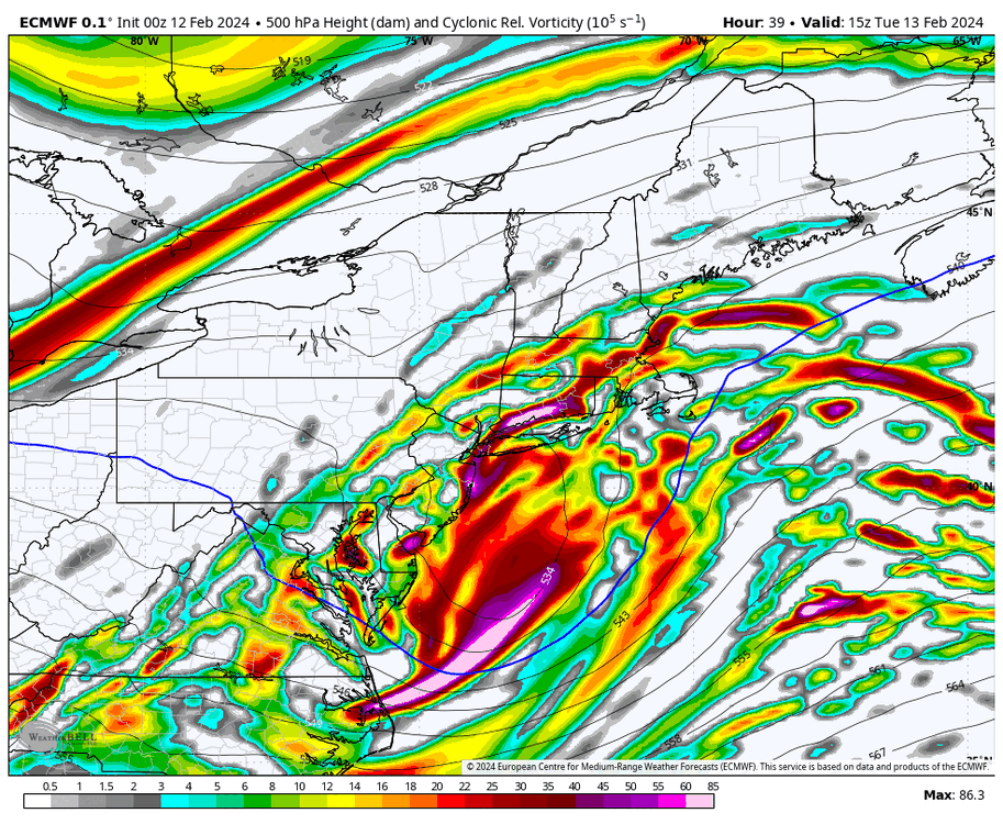
24 minutes ago, brooklynwx99 said:
there is a stacked, strengthening mid-level ULL south of LI... this often fosters the development of a CCB in the NYC area. we have seen significant shifts today that has placed NYC firmly in the axis of heaviest snow
.thumb.png.bee3c8b81af6ebc4e22917bf38c0070d.png)
That run checks the boxes. Later today hopefully more/better.
-
1
-
-
11 minutes ago, Bxstormwatcher360 said:
I think it snows to beat the band. Also reguardless of the recent milder temps,it was pretty cold before that. Heavy precip and evap cooling take care of the rest when it comes to snow actually accumulating.
We'll see.
-
2 minutes ago, Rjay said:
No lol. I'm still not sold. Can't have bumps north tomorrow.
It's fine to be unsure though. Snowman19 needs to learn that.
Agreed.
-
The mid level evolution-that would get the job done. Again we'll see if there's agreement tomorrow but awesome.
-
2
-
-
Ehh, we'll see. Good trends tonight but maybe add a sloppy inch in NYC and maybe 3-4" IMBY, 1-3" south shore. Can very easily reverse tomorrow. If that Euro run happens verbatim it'll be a pounding. We'll see.
-
1
-
-
2 minutes ago, Nibor said:

He's looking on the south shore though.

I love Curb
-
1
-
 1
1
-
-
Just now, Rjay said:
Exactly
Time to buy in?
-
Mid level tracks check out here too, all decently south of LI.
-
2
-
-
5 minutes ago, rickrd said:
0z Euro
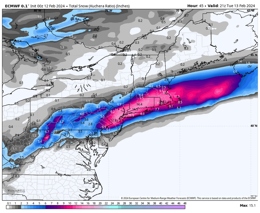
Yikeee-zees.
-
1
-


.png.83bd600da707fb505b3fe4b942bc8b45.png)

2/13 Significant/Major Winter Storm Discussion & Observations
in New York City Metro
Posted
Yep a step back. We'll see what happens in the morning.