jm1220
-
Posts
25,896 -
Joined
-
Last visited
Content Type
Profiles
Blogs
Forums
American Weather
Media Demo
Store
Gallery
Everything posted by jm1220
-
2-7-21 Sunday 8-12 hour nor'easter snowstorm roughly 5A-5P
jm1220 replied to wdrag's topic in New York City Metro
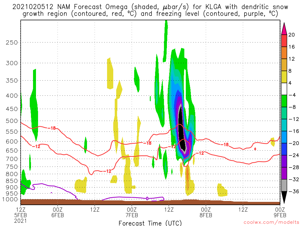
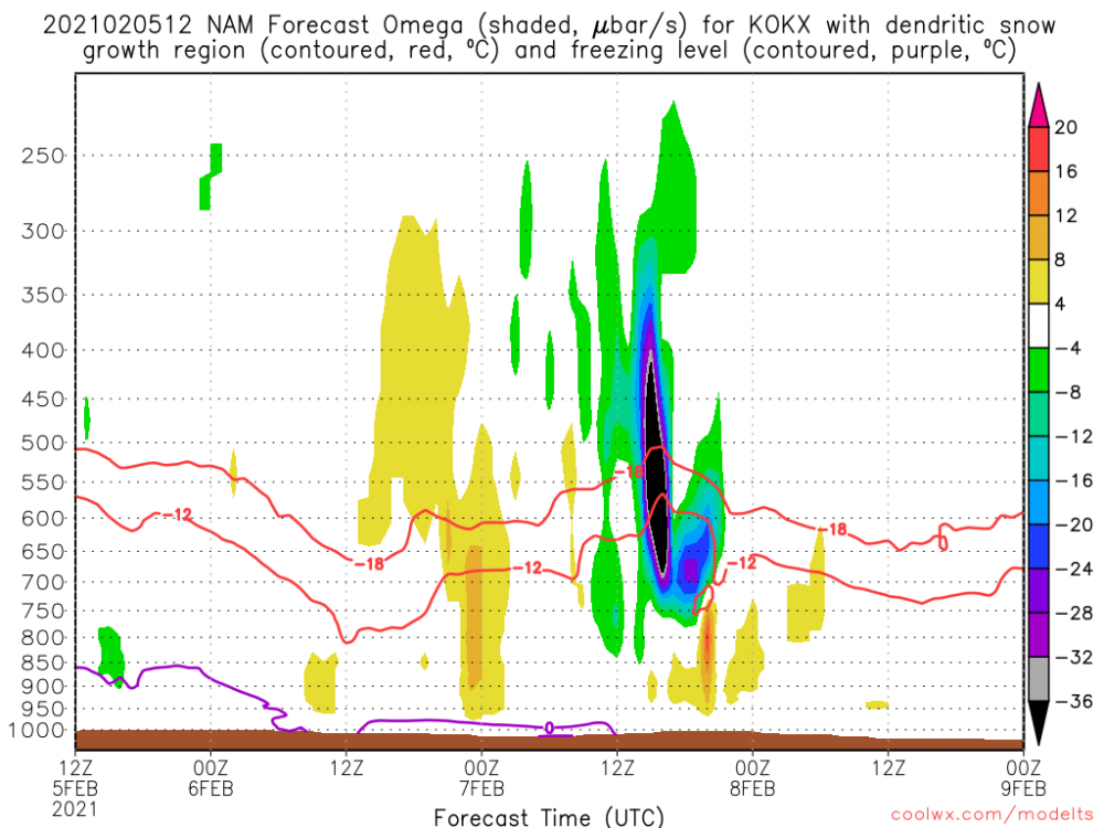
For OKX and HPN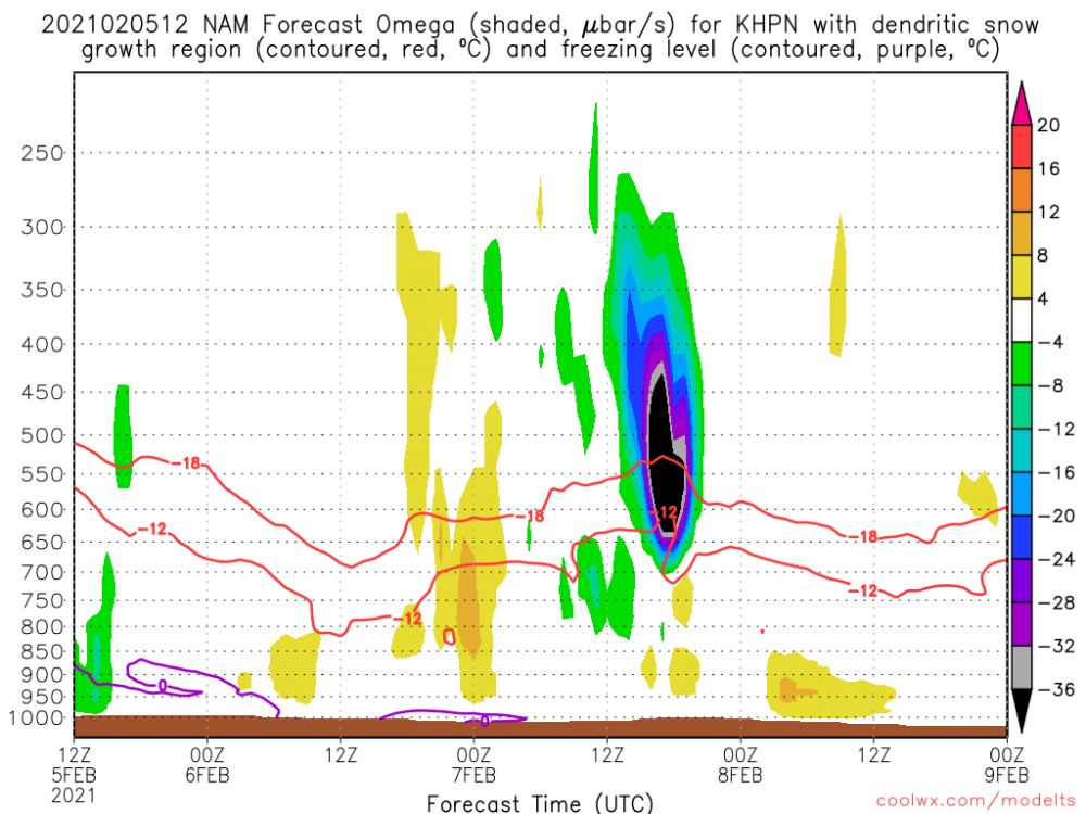
-
2-7-21 Sunday 8-12 hour nor'easter snowstorm roughly 5A-5P
jm1220 replied to wdrag's topic in New York City Metro
If this is right, short lived but very heavy rates and lift squarely in the -12 to -18C part pf the column. For LGA:
-
2-7-21 Sunday 8-12 hour nor'easter snowstorm roughly 5A-5P
jm1220 replied to wdrag's topic in New York City Metro
That would be insane on the level of the last storm in terms of rates, probably 2-3”/hr. Of course moving much faster but a very fun 6-8 hours. -
2-7-21 Sunday 8-12 hour nor'easter snowstorm roughly 5A-5P
jm1220 replied to wdrag's topic in New York City Metro
Most TV Mets are just lousy. They were way underdone east of the city on the last storm until the morning of and even then we were on the top end of the ranges if not higher. Upton was generally overdone but was better. There are some exceptions like Craig Allen but not many. I’m sure by 5pm those will be upped and we might be under a watch anyway. -
2-7-21 Sunday 8-12 hour nor'easter snowstorm roughly 5A-5P
jm1220 replied to wdrag's topic in New York City Metro
In this case the 700 low is taking a great track for coastal areas. I haven’t looked at maps/soundings for where the max lift is but if it’s in the -12 to -18c layer that’s the best for high ratios. -
2-7-21 Sunday 8-12 hour nor'easter snowstorm roughly 5A-5P
jm1220 replied to wdrag's topic in New York City Metro
Thanks-I’ve seen it mentioned before but didn’t know much about it. -
2-7-21 Sunday 8-12 hour nor'easter snowstorm roughly 5A-5P
jm1220 replied to wdrag's topic in New York City Metro
What’s the Cobb method based on? I don’t see anyone getting 16” from a fast mover like this. Maybe someone gets 10-12” in one of the heavy bands. It would be a general 6-10” type deal otherwise. -
2-7-21 Sunday 8-12 hour nor'easter snowstorm roughly 5A-5P
jm1220 replied to wdrag's topic in New York City Metro
GGEM came in a good bit NW also like the RGEM. -
2-7-21 Sunday 8-12 hour nor'easter snowstorm roughly 5A-5P
jm1220 replied to wdrag's topic in New York City Metro
Hopefully for comparison we get the v16 GFS today. -
2-7-21 Sunday 8-12 hour nor'easter snowstorm roughly 5A-5P
jm1220 replied to wdrag's topic in New York City Metro
I'm fairly confident here we have a few inches to rebuild/freshen the snow pack but hopefully it can be more. You need something quite amped in this setup to get it well NW of the city but the NAM would get it done. -
2-7-21 Sunday 8-12 hour nor'easter snowstorm roughly 5A-5P
jm1220 replied to wdrag's topic in New York City Metro
Geez. Hopefully it had a clue here and we see the other models go the same way. -
Southerly flow off the ocean raising temps quite a bit here. Temp 40 now.
-
Don’t think it got quite that warm here but some more snow on Sun would be nice. We’re losing more today too.
-
2-7-21 Sunday 8-12 hour nor'easter snowstorm roughly 5A-5P
jm1220 replied to wdrag's topic in New York City Metro
Fine by me. I’d rather be on the northern edge of these than sweating the rain snow line. A few inches or so to build/refresh the pack works. -
2-7-21 Sunday 8-12 hour nor'easter snowstorm roughly 5A-5P
jm1220 replied to wdrag's topic in New York City Metro
They had a large chunk of the storm as rain here but 95% of it was snow. -
2-7-21 Sunday 8-12 hour nor'easter snowstorm roughly 5A-5P
jm1220 replied to wdrag's topic in New York City Metro
They were pretty significantly too amped with the past storm at around this range. -
2-7-21 Sunday 8-12 hour nor'easter snowstorm roughly 5A-5P
jm1220 replied to wdrag's topic in New York City Metro
18z and 6z runs also incorporate updated data. It’s a myth that somehow they just run off previous 12z or 0z data. -
2-7-21 Sunday 8-12 hour nor'easter snowstorm roughly 5A-5P
jm1220 replied to wdrag's topic in New York City Metro
Looking pretty strongly like this will be a hit in some way for most of us. Coast is favored this time but models like the Nam spread the fun well inland too. -
2-7-21 Sunday 8-12 hour nor'easter snowstorm roughly 5A-5P
jm1220 replied to wdrag's topic in New York City Metro
Yes it's a southern stream wave, but embedded in a fast pattern and not slowing down/amplifying too much. NAM would be the best outcome obviously but at this range it can be too amped. Hopefully others trend NW again at 18z/0z. -
2-7-21 Sunday 8-12 hour nor'easter snowstorm roughly 5A-5P
jm1220 replied to wdrag's topic in New York City Metro
Still time for it to come NW enough for most of us to get a few inches and possibly more near the coast. The nature of this being an Arctic wave means it won’t be a long lasting event- it won’t amplify like crazy and slow down. This wouldn’t be the kind of storm for huge amounts, maybe 6-8” type stuff at most. -
2-7-21 Sunday 8-12 hour nor'easter snowstorm roughly 5A-5P
jm1220 replied to wdrag's topic in New York City Metro
Good sign IMO. Hopefully we can trend it and amp it enough for a 3-6 type event down here. -
2-7-21 Sunday 8-12 hour nor'easter snowstorm roughly 5A-5P
jm1220 replied to wdrag's topic in New York City Metro
The SE ridge often trends more amped at the last minute and is characteristic of Nina winters so that can help us here. -
2-7-21 Sunday 8-12 hour nor'easter snowstorm roughly 5A-5P
jm1220 replied to wdrag's topic in New York City Metro
Arguably the very intense snow the NYC area had on Monday would’ve been less so if the water temps were a few degrees cooler. The length overall made for the probably record amount in NJ but the easterly jet on it was like a mini atmospheric river from the east and it was cold enough for that to be snow. And it wasn’t that powdery a snow, it’s water logged.