It's Always Sunny
-
Posts
1,947 -
Joined
-
Last visited
Content Type
Profiles
Blogs
Forums
American Weather
Media Demo
Store
Gallery
Everything posted by It's Always Sunny
-
HM is the go to for this but put very simply it is the amount of westerly momentum (or lack thereof) occurring around the globe. GSDL plots only show what has already happened so you can't really forecast based on that but it gives a snapshot of current conditions (total GLAAM, FT, MT, tendencies, etc). Gensini has a nice webpage that shows AAM forecast but it currently is not up to date. Also has a strong low bias since it is GFS based. To be perfectly honest it's a nice tool to have but if you don't have access to AAM model guidance (which most don't unless you have a high tier WxBell account or if Gensini's site updates), deterministic and ensemble models along with teleconnections are pretty much all you need in my opinion. Here is a post I made yesterday pertaining to AAM & MJO where you can use AAM to support a forecast but without the AAM forecast models themselves it is hard to solely rely on:
-
I agree but a -IOD can enhance Walker Circulation = more robust convection over Maritime Continent = potentially more robust NPac Jet which can influence what infiltrates the Lower 48. This is one area that I think more research is needed to get a better grasp to specific impacts but from a general understanding this is what transpires.
-
I think the IO is one of the most underplayed influences in long range forecasting. Meteorologically still more to be discovered but it is a known driver of the NPAC jet which obviously has downstream impacts.
-
What is the main difference between the two? They both appear to have the same functionality.
-
Great link! Bookmarking this one. Thanks.
-

Severe Weather event October 23rd-27th 2021
It's Always Sunny replied to weatherextreme's topic in Central/Western States
Storms were uneventful in DFW this morning. Mainly just rain, moderate to heavy for the most part. Only recorded 0.42" so far. -
Makes sense. Have you noticed the NAM having less of a NW tug with coastals since it is non-hydrostatic? Tbh I don't look at the NAM as much as I should so I can't say whether or not that tendency is there.
-
Off topic question....I may have asked this before and forgot to take note of it (or check in on the person's response) but what is the general cause for NW trends for coastals? Beta drift or something else? Thanks in advance.
-
Texas/Oklahoma Discussion & Obs Thread 2021
It's Always Sunny replied to It's Always Sunny's topic in Central/Western States
It wasn't, but overnight Tuesday has potential. -
Starting to heavily doubt any tornadic potential in SE MO. Mesoanalysis showing capped surface layer where models had it uncapped earlier. If anything develops there ahead of approaching squall line it'll likely be elevated.
-
October Discussion: Bring the Frost-Hold the Snow
It's Always Sunny replied to 40/70 Benchmark's topic in New England
-
October Discussion: Bring the Frost-Hold the Snow
It's Always Sunny replied to 40/70 Benchmark's topic in New England
Sooooo you going for a jog? -
October Discussion: Bring the Frost-Hold the Snow
It's Always Sunny replied to 40/70 Benchmark's topic in New England
Woah. I had to look up where Farmington, ME is; that's nestled in there too (not near the coast) which makes that record even more alarming. How's it looking for that 24-26th window last I checked it looked like some freezing temps were going to infiltrate a good portion of New England. -
October Discussion: Bring the Frost-Hold the Snow
It's Always Sunny replied to 40/70 Benchmark's topic in New England
Yeah the 24-26th window has potential for freezing temps. -
October Discussion: Bring the Frost-Hold the Snow
It's Always Sunny replied to 40/70 Benchmark's topic in New England
Many will probably see their first freeze date occur in the upper 15th percentile (later than normal). Growing season continues. -
Texas/Oklahoma Discussion & Obs Thread 2021
It's Always Sunny replied to It's Always Sunny's topic in Central/Western States
47F at DFW this morning. Fall is in the air! -
Texas/Oklahoma Discussion & Obs Thread 2021
It's Always Sunny replied to It's Always Sunny's topic in Central/Western States
51F at DFW this morning. Coldest temperature since April 25th! -
October Discussion: Bring the Frost-Hold the Snow
It's Always Sunny replied to 40/70 Benchmark's topic in New England
"Moist physics" will be an oft used term here lol -
October Discussion: Bring the Frost-Hold the Snow
It's Always Sunny replied to 40/70 Benchmark's topic in New England
I can already envision the New England forum scrutinizing where snow gradients orient themselves compared to the former (if it is still publicly available for a bit). It would probably be wise to keep it running through the winter to see how it verifies even if it isn't expected to be as accurate. -
October Discussion: Bring the Frost-Hold the Snow
It's Always Sunny replied to 40/70 Benchmark's topic in New England
It's the new ECMWF deterministic model set for release in 2 days. -
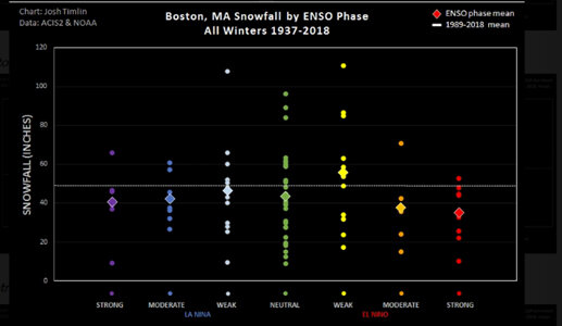
Not sure what you're talking about Boston got 81" that winter. It's on the graph...
-
October Discussion: Bring the Frost-Hold the Snow
It's Always Sunny replied to 40/70 Benchmark's topic in New England
47r3 T-2 days... -
Severe Weather October 10th-12th 2021
It's Always Sunny replied to Sydney Claridge's topic in Central/Western States
Yeah just saw that. Doesn't increase our tornado chances here though but wind chances now 30% which is reasonable. -
Severe Weather October 10th-12th 2021
It's Always Sunny replied to Sydney Claridge's topic in Central/Western States
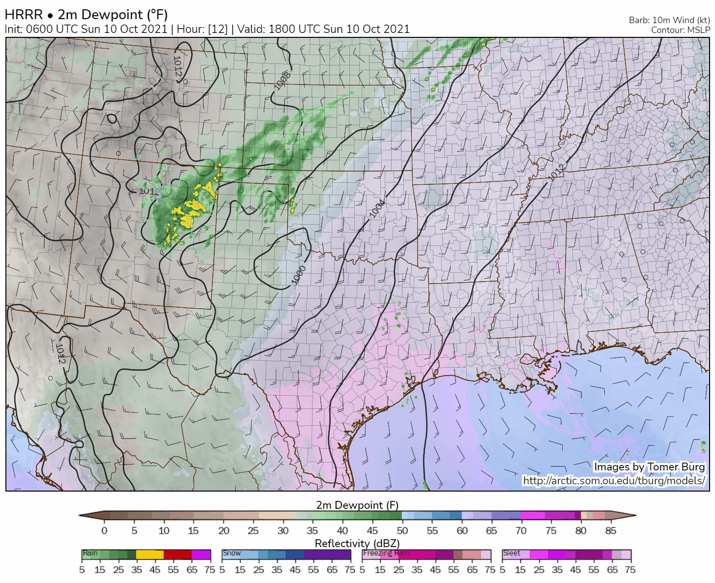
Here is a good visualization of how today will materialize per the HRRR model. 2m dew points overlaid with 10m winds and reflectivity. You can see the surface cold front overrunning the dry line triggering tstms west of I-35.
-
I agree it's good to see La Nina strengthen per guidance but you also don't want too strong of a Nina either imho. In my head I've always told myself a weak Nina to weak Nino is ideal for good SNE snows. I found this graphic as a visual and it actually mirrors this line of thought, with moderate Nina also proving favorable. This is for Boston: