


It's Always Sunny
-
Posts
1,947 -
Joined
-
Last visited
Content Type
Profiles
Blogs
Forums
American Weather
Media Demo
Store
Gallery
Everything posted by It's Always Sunny
-
Seeing all these pics makes me regret not taking any on Blue Hill that day what a complete paste job. Downed tree and several limbs whole way up access road. Then again I didn't have a smart phone with a camera just my Samsung Intensity keypad phone lol. I do need to dig up my pics from Jan 26-27, 2015 blizzard though. I was part of the jackpot band in Boxboro at the time. What a great storm.
-

2019 ENSO
It's Always Sunny replied to AfewUniversesBelowNormal's topic in Weather Forecasting and Discussion
Yeah I was looking at that yesterday it's definitely not out of the realm of possibility. Do you know what may be causing the NOAA/NASA/BoM models to go stronger? Wasn't sure if it was a model bias of some sort. One thought of mine is that those models in particular have a stronger area of suppression over the central Pacific resulting in stronger easterlies? -
Yep, mainly in low-mid troposphere.
-
2019 ENSO
It's Always Sunny replied to AfewUniversesBelowNormal's topic in Weather Forecasting and Discussion
I agree. CFS showing it to a lesser degree: -
2019 ENSO
It's Always Sunny replied to AfewUniversesBelowNormal's topic in Weather Forecasting and Discussion
I think July is optimistic (I was thinking as early as late August/early September) but if that EWB continues that robust end of July onset could be possible. Latter half of hurricane season should be interesting that’s for sure. -
Central/Western Medium-Long Range Discussion
It's Always Sunny replied to andyhb's topic in Central/Western States
Yeah I started noticing that possibly happening last week and today I was looking at the subtropical jet and it loses it's steam next week which further dampens any severe risk, at least here in the Plains however with some troughing remaining over the Southeast there still remains a possibility they get a day or two of severe potential, even with a "weakened" subtropical jet. This "lull" has the potential to spill into the first week of May based on what I was looking at but too far out for me to put much stock in it at this time. -
Central/Western Medium-Long Range Discussion
It's Always Sunny replied to andyhb's topic in Central/Western States
Op GFS remains active for remainder of the month so remains to be seen if it changes course. -
Central/Western Medium-Long Range Discussion
It's Always Sunny replied to andyhb's topic in Central/Western States
Next week or so looks favorable for severe but end of the month/early May in question with EPO trending positive per GEFS. EPS following similar suit. -
Central/Western Medium-Long Range Discussion
It's Always Sunny replied to andyhb's topic in Central/Western States
Once that ULL passes through in about 4 days or so the ensembles remain mostly favorable through the end of the month for unsettled weather here, including severe potential. May not be in your backyard stuff but even on the 12th that area just east of the panhandle and over SW OK could be in a marginal or slight risk potentially and of course that can all shift so not a high confidence forecast by any means but there is certainly potential imo. Then from there on out we still got ridging over the west and troughing over central part of CONUS. That along with climo (it still being early in the month) I remain optimistic which I feel like is the general consensus here beyond day 10. -
-
April 3rd holds some stock but I agree with you long range ensembles look favorable for an uptick in southern plains severe beginning end of second week of April with PNA going negative and that ridging pattern across much of the eastern US retreating. Soil moisture will be abundant with all this rain we've been getting.
-
Dallas becoming the new Seattle...
-
SPC pulled back on western extend of slight and keeps it mainly confined to central-northern LA but looking at it closer (on 12Z NAM) not that impressed with wind fields for any sort of tornadic risk. Best kinematics occur before precipitation gets there with little instability in general appears to be more of a wind/hail risk.
-
Our weather station hit 92.7F which I feel is on the warm side especially with surrounding stations reporting upper 80's (maybe a couple 90F readings) but either way nice heat up yesterday (and today for that matter). There was lightning with that activity that passed to our north originating from the dry line. Don't really know what influence these early heat ups have on our storm season I mean technically it is already underway and we've had a few decent days here. I would also think any heat up or warm stretch we get would benefit our severe potential here for the reasons you mentioned above.
-
Cell isn't competing against a whole lot should continue to hold together.
-
Storm is about 40 miles west of Huntsville definitely bears watching.
-
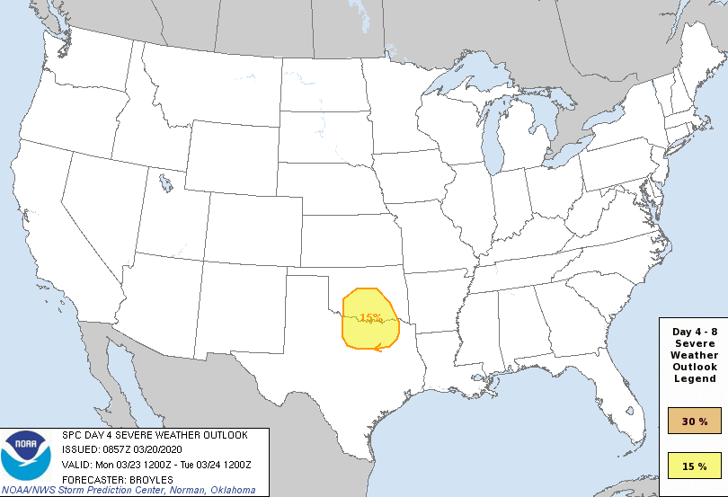
SPC thinking there could be some severe potential in the Metroplex up through OKC on Day 4. Appears to be a nighttime potential:
-
Absolute torch today. Wx station at home is reading 90F with other wx stations around reading between 88-90F so it's legit! Should set the stage for some good thunderstorms tomorrow night.
-
Some severe potential coming together for DFW early evening tomorrow along nice surface convergence boundary. Cap appears to be in place but around 21Z models erode it. Hodos have a weak and subtle curve but may generate a couple isolated supercells. SPC has marginal out so it definitely bears some watching. Risk overall is low but certainly bears watching.
-
Yeah I agree to not put too much stock into ops models this far out but ensembles do favor unsettled weather around here first week of March so we'll see how it verifies. Ensembles mid to late March don't look quite as favorable (at least for now).
-
Had nothing significant here near DFW airport other than some wintry mix that ended up melting once it hit the surface but I think models did a fairly good job depicting the northwest to southeast temperature gradient.
-
I agree. These fronts are always so shallow which keeps me leery of the entire column cooling enough to produce wintry precip.
-
The cold air will obviously be there at the surface but I'm more focused on the temperatures aloft which will be the determining factor. GFS nukes lower levels (resulting in cold rain/freezing rain) while NAM and Euro run colder (likely sleet/snow/patchy freezing rain).
-
Lots of varying solutions with NAM being the coldest thus far. It's still too early to tell if Dallas will be a wintry mix or cold rain.
-
Ratios were crap though doesn't matter if it's freezing at the surface. 5:1 ratio amounts will give you that.
