

AfewUniversesBelowNormal
-
Posts
4,753 -
Joined
-
Last visited
Content Type
Profiles
Blogs
Forums
American Weather
Media Demo
Store
Gallery
Everything posted by AfewUniversesBelowNormal
-
 Vera was the strongest typhoon to ever hit Japan, Cat3 https://en.wikipedia.org/wiki/Typhoon_Vera Much different path, this one. Beyond that, 30% of Japans population is at projected landfall in maybe the best angle possible for maximum impact.
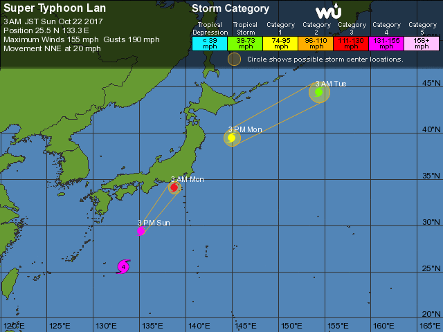
.gif.126564fcc3935bb375cee8bda80401aa.gif)
-
Hermine shifted 240 degrees in the Gulf. It's early in the season for NHC track
-
re: post
It's just lazy. those things aren't modeled well 5 days in advance vs climatology. They accept average error mark of X and keep doing it
-
Has anyone considering plotting 9 planetary +1 moon position in the 360 sky, include angles to each other, versus World weather, also +++ so many days, going back as far as satellites have been plotting data? it would be over ten thousand variables. Could be awesome. I would do it with fast software. You could go forward 1000 years
-
Arctic Sea Ice Extent, Area, and Volume
AfewUniversesBelowNormal replied to ORH_wxman's topic in Climate Change
Solar Cycle, decadal Water oscillations, and probably even greenhouse emissions is very simplistic of view of the world, I think. There is expanded communication happening now on awesome levels and even our ability to view the universe is 10,000x greater than before. This is a point in human consciousness evolution that history doesn't really have a point of reference for, shifting into new energy fields, dream perception, or something... new the Earth's warming is just a really measurable part of it. -
Arctic Sea Ice Extent, Area, and Volume
AfewUniversesBelowNormal replied to ORH_wxman's topic in Climate Change
I think Internet is a small wave inside a bigger wave. 1995 was internet boom, and 97-98 was major Earth climate cycle shift, super El Nino etc. Technology with regards to climate impact has pretty much halted since the 1970s, why are global temperatures spiking so anomalously in the last 20 years? Seriously though, technology has flat lined (cars, houses, NASA, etc), the Earth is speeding up major now. I think there other factors at play, probably having do with government. -
Arctic Sea Ice Extent, Area, and Volume
AfewUniversesBelowNormal replied to ORH_wxman's topic in Climate Change
It takes 2-3 years for the Earth to really catch up to Arctic ice area. -
Two Days in August in Washington, DC
AfewUniversesBelowNormal replied to RodneyS's topic in Mid Atlantic
140 years is a big enough sample to seriously consider something other than coincidence at work. While I can't come up with a reasonable explanation for your data, nothing can be dismissed as a possible cause. Pure luck would make this a decent mathematical anomaly. Do you have data on rainfall days during these times? It is also possible that a few Tropical systems are significantly skewing the averages.