

AfewUniversesBelowNormal
-
Posts
4,753 -
Joined
-
Last visited
Content Type
Profiles
Blogs
Forums
American Weather
Media Demo
Store
Gallery
Everything posted by AfewUniversesBelowNormal
-
Now the modeled pattern is shifting a little bit. I think more in an AMO thing though.
-
Some things on this forum are rather threatening
-
Who is Cobalt? Do you think that's rain?
-

Arctic Sea Ice Extent, Area, and Volume
AfewUniversesBelowNormal replied to ORH_wxman's topic in Climate Change
It looks now like it may go into a stronger Nino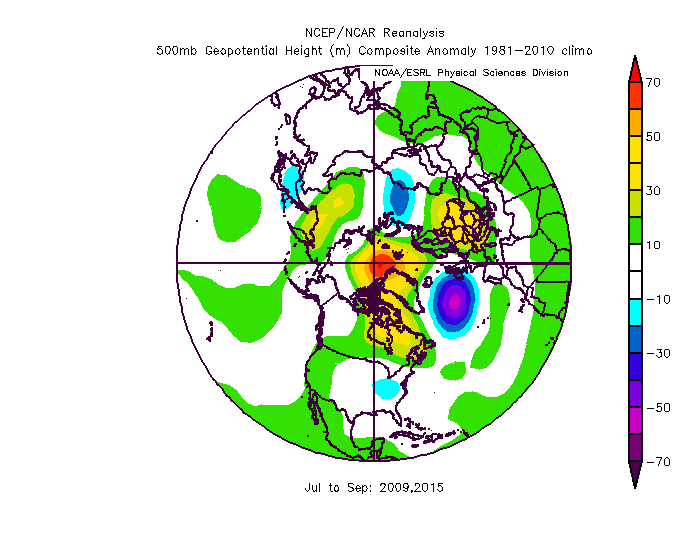
-
Arctic Sea Ice Extent, Area, and Volume
AfewUniversesBelowNormal replied to ORH_wxman's topic in Climate Change
Ok.. look at how this filled in in the north part of Greenland then become an arctic circle block (models were consistently negative anomaly here until a day ago). I think this is the same trend from the Winter and it will be a large arctic ice melt season -
Arctic Sea Ice Extent, Area, and Volume
AfewUniversesBelowNormal replied to ORH_wxman's topic in Climate Change
-
Definitely El Nino, subsurface is leading indicator
-
Subsurface trends early 2018 has 7 analogs.. 3 went El Nino, 4 were Neutral. The way it's going, I would guess Weak or low end Moderate El Nino as a max, about the same % chance for Neutral, and slight chance we go back to Weak Nina in the Fall. Hurricane season is probably active with a lot of US misses.
-
Southeast Sanitarium - A Place to Vent
AfewUniversesBelowNormal replied to Jonathan's topic in Southeastern States
I would think in a 1000 year period the largest snowfall would happen in the Southeast, US. probably Florida -
Central/Western Medium-Long Range Discussion
AfewUniversesBelowNormal replied to andyhb's topic in Central/Western States
This is some pretty awesome cold for April. Wonder if it verifies. -
98-99, 99-00, 00-01. It's not too uncommon. 54-56 had a nice streak. 73-76 http://origin.cpc.ncep.noaa.gov/products/analysis_monitoring/ensostuff/ONI_v5.php I think a 3rd Nina year would be weird because of Global warming bias right now. 1 center El Nino event since 2010 in this exponentially warming climate?
-
Don't expect it to go El Nino anytime soon.. subsurface for this late in the Winter may even support a Nina rebound in the Summer if it doesn't persist at the surface
-
Southeast Sanitarium - A Place to Vent
AfewUniversesBelowNormal replied to Jonathan's topic in Southeastern States
You'll love this one, Global warming is another way of saying dimension split.. we are on really really low end here. Almost to the point of not going back but not quite yet but we are heading that way -
The SST movement changes direction next few weeks. This is when you'll see it change or not, some people say a Kelvin wave like we had is a preceding mark. Those +subsurface in the western regions are impressive. I think it's strengthening versus climo is a strong signal for North Pacific -PNA, like we are seeing now. The whole pattern has shifted north 200 miles so you aren't going to see severe wx setups like early 2000s
-
What a happening in Texas in February!
-
CPCs subsurface were substantially more Nina last month, TAO/Triton this is most extreme of event now. imo TAO is better
-
I don't know much about the QBO. QBO, MJO, AAM sound like new age terms. It was so cool to see precip patterns change when the SOI went negative Check out the NOI or SOI*
-
It's strengthening a little bit, a lot versus climatology for this time of year. In El Nino transition, it's usually a little different right now meaning this probably goes until April
-
160W is the point for the 200m warm anomalies to cross or not.. this is La Nina signature, and higher western thermocline is probably better forcing for North pacific ridge than cold east
-
Arctic Sea Ice Extent, Area, and Volume
AfewUniversesBelowNormal replied to ORH_wxman's topic in Climate Change
Feb 10-28 Stratosphere warming to March -
You dont have frost?
-
Arctic Sea Ice Extent, Area, and Volume
AfewUniversesBelowNormal replied to ORH_wxman's topic in Climate Change
Nov-Feb 2017-2018 will finish the greatest +500mb in the Arctic Circle on record, significantly above number 2. -
It's really hard to get a drought here because we average like 4" per month. You would need something like 10/40 potentials to hit
-
Arctic Sea Ice Extent, Area, and Volume
AfewUniversesBelowNormal replied to ORH_wxman's topic in Climate Change
? Check out the images on NASA. Not only have 2015-2016-2017 been substantially warm but it looks like we will go ice free in 10 years just by following basic trend lines Also of note is arctic 500mb heights this Winter through Nov 1 - Feb 5 have been greater than any year since 2013, and substantially warmer than 2015-2016-2017 Winters. I would say just by going by basic probability there is a >50% chance that this Summer is the lowest arctic ice to date