Met1985
-
Posts
16,909 -
Joined
-
Last visited
Content Type
Profiles
Blogs
Forums
American Weather
Media Demo
Store
Gallery
Everything posted by Met1985
-

2025 Spring/Summer Mountain Thread
Met1985 replied to Maggie Valley Steve's topic in Southeastern States
Only 60 degrees at 1pm on August 4th... Again like a broken record simply amazing. -
2025 Spring/Summer Mountain Thread
Met1985 replied to Maggie Valley Steve's topic in Southeastern States
Had a low of 53 degrees this morning. Saw that Mt Mitchell got down to the low 40s... -
2025 Spring/Summer Mountain Thread
Met1985 replied to Maggie Valley Steve's topic in Southeastern States
Stuck at 60 degrees and drizzle. Absolutely gorgeous weather out! -
2025 Spring/Summer Mountain Thread
Met1985 replied to Maggie Valley Steve's topic in Southeastern States
The magic of cold air damming: Three days ago, Asheville's low temp was 71 degrees, which tied a record for the warmest low temp for 7/31. Yesterday, Asheville's high temp was 71 degrees, which set a new record for the coolest high temp for 8/2. -
2025 Spring/Summer Mountain Thread
Met1985 replied to Maggie Valley Steve's topic in Southeastern States
Not at home but those temps sound amazing. An early taste of Fall. -
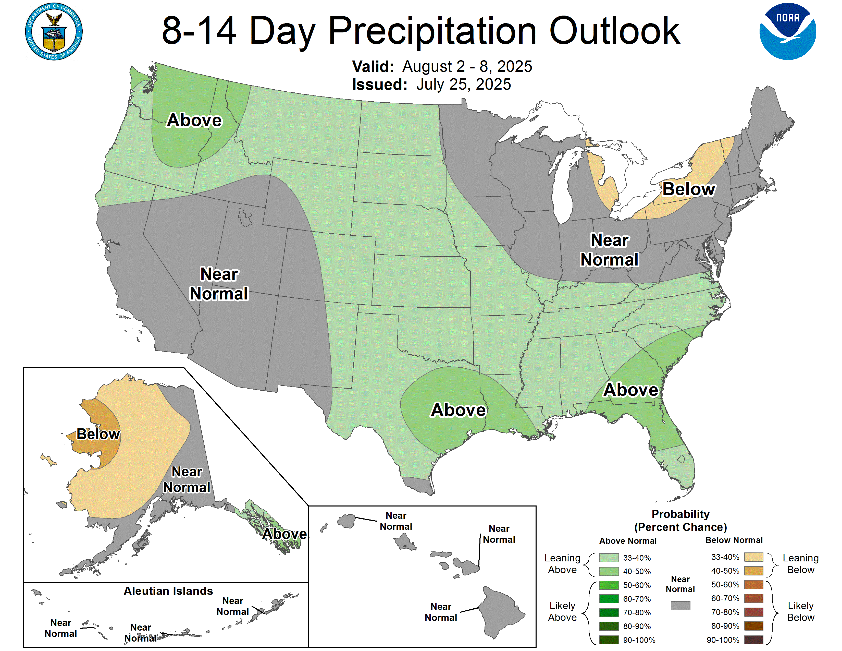
Amazing for the first of August!
-
May not hit 70!
-
2025 Spring/Summer Mountain Thread
Met1985 replied to Maggie Valley Steve's topic in Southeastern States
Yeah this week has been brutal. -
2025 Spring/Summer Mountain Thread
Met1985 replied to Maggie Valley Steve's topic in Southeastern States
Freaking beautiful -
2025 Spring/Summer Mountain Thread
Met1985 replied to Maggie Valley Steve's topic in Southeastern States
Looks like a chance of severe weather today. -
2025 Spring/Summer Mountain Thread
Met1985 replied to Maggie Valley Steve's topic in Southeastern States
Had more rain today with only a high of 76 and a current temp of 68 degrees. The humidity is thick but these temps are golden. -
2025 Spring/Summer Mountain Thread
Met1985 replied to Maggie Valley Steve's topic in Southeastern States
Been raining for hours at home and looks like it's set in. -
I don't think that will happen.
-
2025 Spring/Summer Mountain Thread
Met1985 replied to Maggie Valley Steve's topic in Southeastern States
Today was miserable. Luckily only 2 to 3 more days of this crap weather. -
2025 Spring/Summer Mountain Thread
Met1985 replied to Maggie Valley Steve's topic in Southeastern States
This is a banger of a storm. Torrential downpours with a bit of hail. -
2025 Spring/Summer Mountain Thread
Met1985 replied to Maggie Valley Steve's topic in Southeastern States
Multiple storms today with another one knocking on the door. -
2025 Spring/Summer Mountain Thread
Met1985 replied to Maggie Valley Steve's topic in Southeastern States
Shoot today's gfs has highs in the 60s and lows in the 50s next weekend. That would be freaking amazing. -
2025 Spring/Summer Mountain Thread
Met1985 replied to Maggie Valley Steve's topic in Southeastern States
This will be a treat for the first of August Sent from my SM-G998U using Tapatalk
-
Cancer freaking sucks. So sorry for your loss. He will be missed.
-
Went up to Roan mountain yesterday for the first time. Hiked up to the Bluff and walked around Carvers Gap. The destruction up there was unbelievable. I couldn't imagine the sustained winds up there being 100 plus mph. It's beautiful up there and rained on and off all day.
-
Been in Johnson City since Wednesday. The storms that rolled through here last night and Thursday night were some serious storms. High winds, torrential rainfall and lots of lightning.
-
2025 Spring/Summer Mountain Thread
Met1985 replied to Maggie Valley Steve's topic in Southeastern States
Storms starting to pop today already. -
2025 Spring/Summer Mountain Thread
Met1985 replied to Maggie Valley Steve's topic in Southeastern States
Today is going to be booming again. You can feel it in the air. -
2025 Spring/Summer Mountain Thread
Met1985 replied to Maggie Valley Steve's topic in Southeastern States
Yep I believe it. Big slow moving storms. -
2025 Spring/Summer Mountain Thread
Met1985 replied to Maggie Valley Steve's topic in Southeastern States
Hellacious storms are here rolling through the area. Home is getting smacked big time along with Asheville area.