

Met1985
-
Posts
16,491 -
Joined
-
Last visited
Content Type
Profiles
Blogs
Forums
American Weather
Media Demo
Store
Gallery
Everything posted by Met1985
-
The old 10-15 day EPS rolled into the new 7-12 day forecast from the EPS. Again and again we've seen this especially this season and yes I'll die on this hill. Sent from my SM-G998U using Tapatalk
-
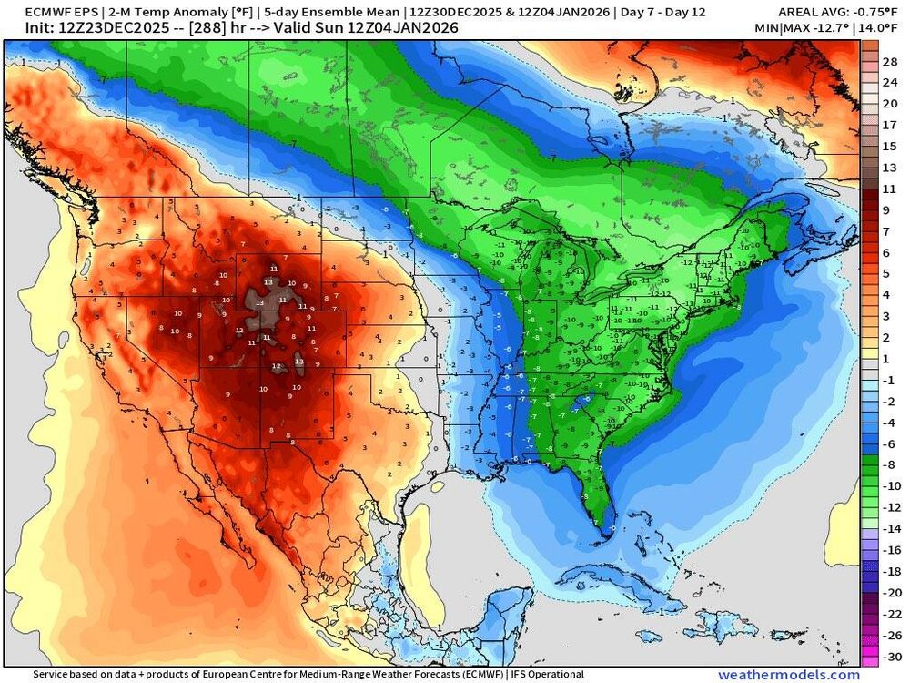
EPS supports the Euro and that's not a really warm look in the long range. Sent from my SM-G998U using Tapatalk
.thumb.jpg.b418b25a4b386e8a530c83d59507aa13.jpg)
.thumb.jpg.b199f0628ec73b1eb1bcdd320e553d30.jpg)
.thumb.jpg.2e7c0655ec573d05b13f2a3d58b6b45c.jpg)
.thumb.jpg.ce97d3239906bd1e346edc60cc9df433.jpg)
-
Whiplash anyone! Sent from my SM-G998U using Tapatalk
-
This is exactly what I've been talking about this week. We've seen this time and time again. And especially on the EURO We've seen even colder solutions in the mid range. Some people are gullible.
-
Euro with two back to back very strong fronts coming in after Christmas now.
-
Looks like we get multiple fronts coming through after Christmas now and more pronounced.
-
Possibly the northern mountains but at this time the cold front looks dry. Unless your into skiing then somewhere like Beech mountain. But at this time the models aren't showing any winter weather around New Years.
-
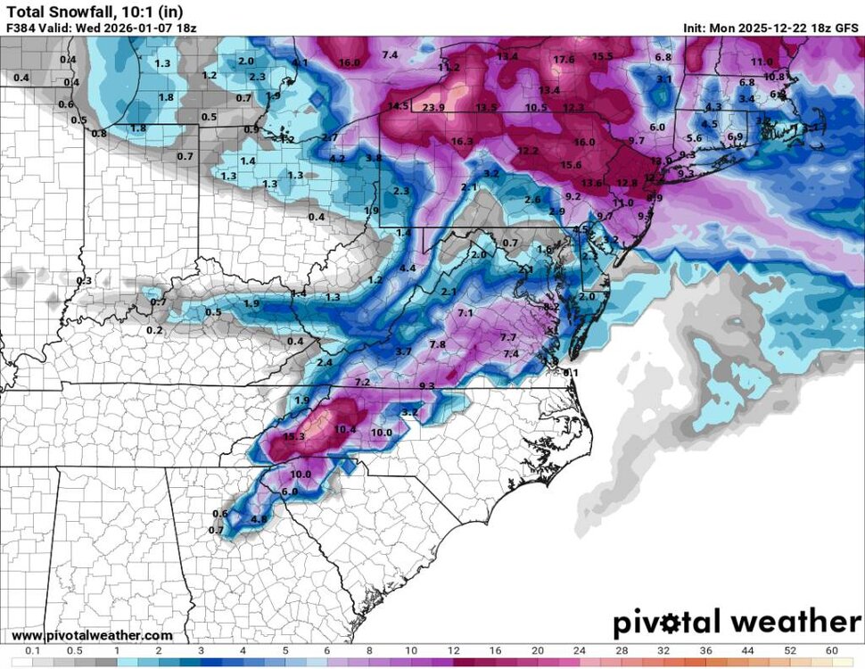
18z gfs snowfall Sent from my SM-G998U using Tapatalk
-
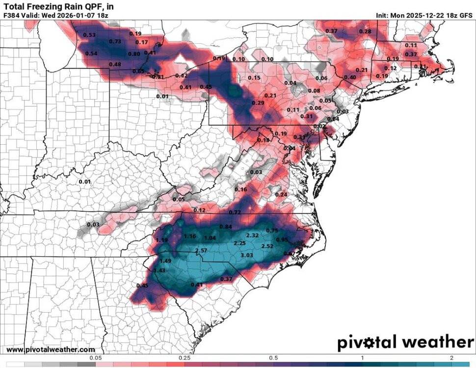
18z freezing rain map. Sent from my SM-G998U using Tapatalk
-

December 2025 Short/Medium Range Forecast Thread
Met1985 replied to John1122's topic in Tennessee Valley
That's freaking awesome. -
The way the models have been adjusting especially with this upcoming cold shot because of the building negative NAO there will be some wild swings especially in the mid range.
-
Not a terrible look from the Euro. Sent from my SM-G998U using Tapatalk

.thumb.jpg.8203498f115adbdcd7c53700bae630b3.jpg)
.thumb.jpg.a024d1c9211fd60991c546593c6ec1d4.jpg)
-
Yup. Lol ill be here all day.
-
The pattern has been showing up being volatile especially this past week. Things have become more clear this weekend especially the recent runs of both the gfs and the EURO. We will agree to disagree. We don't see eye to eye on multiple things anyways.
-
This would be a nice blast of cold after this week. Sent from my SM-G998U using Tapatalk
.thumb.jpg.96ae8f8b31ea508162338bd294302d1a.jpg)
-
I think they have been when trying to extend a warm spell. We've seen them wrong several times this season just as Larry pointed out about the EPS.
-
Im giving you my opinion in the way the models have performed in the long range this season. Honestly we could look decent, torch, or in the freezer. We are just seeing a lot of volatility in the models.
-
I disagree. This is just too far out there with the way the models have been performing this season for the most part.
-
Obviously not. We had a warm period before Thanksgiving. We thought we'd torch right through Thanksgiving but no we had a very cold end to November and a cold start to December. We've been well below average for the better part of 3 weeks. So yes we've seen this several times across the board where yes the operational models and the ensembles have performed very poorly in the middle and long range multiple times this season.
-
We've seen this all season long just about.
-
23 this morning. The sky was falling this weekend but it's stopped I think.
-
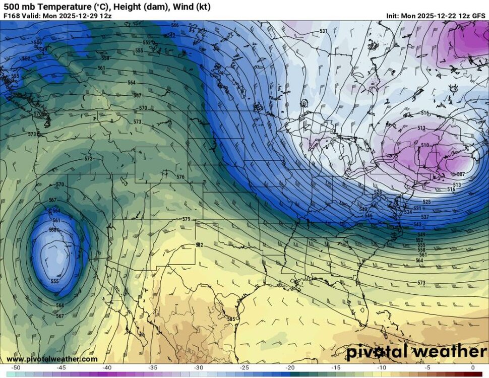
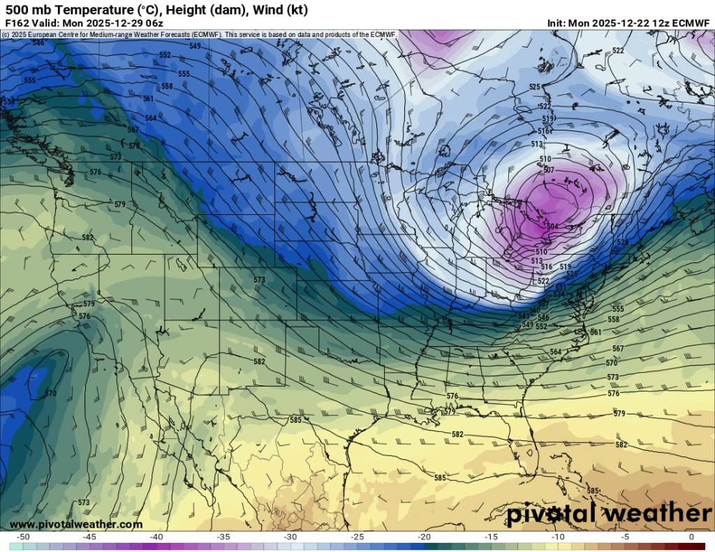
If this trough verifies coming up that would mean non of the ensembles caught this outside day 7. Then the pattern again looks to be up and down. Sent from my SM-G998U using Tapatalk

.thumb.jpg.03c7278e0ca31ebf13722caf83d4fc1f.jpg)
.thumb.jpg.ac96754aa1c52667bd690f2f248b4665.jpg)
-
Probably a record this Christmas as well. We've had several extremes around the south the past couple of years.
-
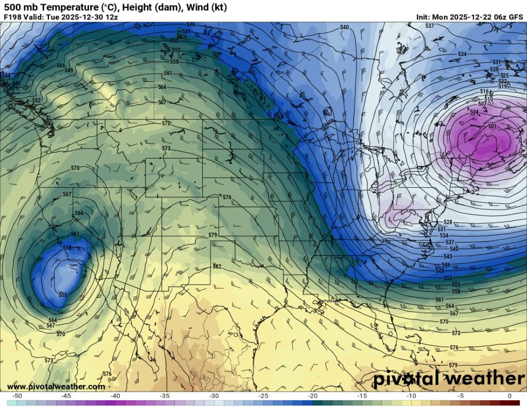
The 12z gfs rolls the trough up top with a backdoor front but amplifies a ridge out west. Yes this coming week is warm but the pattern does jumble up a bit after that. Sent from my SM-G998U using Tapatalk
.thumb.jpg.fe2522063f9dece35c2590da9e5ba697.jpg)
.thumb.jpg.7f204dbef3489b27ac4f06531554f4c3.jpg)
.thumb.jpg.1ca93061372cf59f4c667cc060955385.jpg)
-
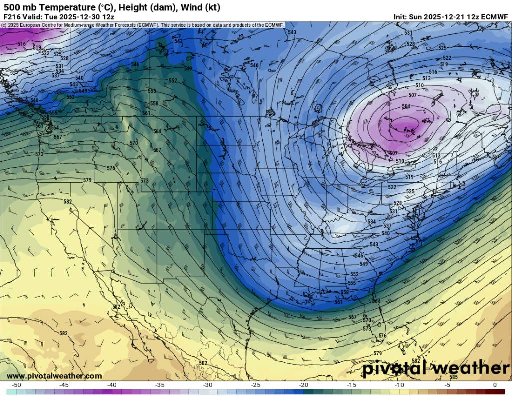
An impressive trough then yes warm-up but then possibly more cold but honestly past day 5 it's a crapshoot. Sent from my SM-G998U using Tapatalk

.thumb.jpg.b851f8c9676223b7938aa39a9a93ee7a.jpg)


.jpg.5ccae67cb51a5eeb790b0f01b979e0b3.jpg)
.jpg.7698da87018a7eb055ef01eb9a51f8b2.jpg)
.jpg.c688a3b53cd961db080321be95a64a02.jpg)
.jpg.6fd8f0d54e4bf435807e9ea3de90ae47.jpg)


.jpg.d839f36c74fddeeb14e72361d36fae68.jpg)
.jpg.9b03dedb58b4f719c6dc38cd615b03d8.jpg)

.jpg.c5f4c7eafdd295bac76c2c41c0469a6d.jpg)
.jpg.cca6ffac0c14129b7b0b7fd86096dc52.jpg)
.jpg.24a7fe90864ecd0ebda6c2950c6dece2.jpg)
.jpg.447c9738319fff4f554848b3d83a5d92.jpg)
.jpg.f8231a4692d5360eef40ba0fd0e5b357.jpg)
.jpg.f4015828b1334e7f4a37c5d912137d98.jpg)


.jpg.3a5f6dddb905f3c4018801463d6e0fc9.jpg)