FLweather
-
Posts
2,419 -
Joined
Content Type
Profiles
Blogs
Forums
American Weather
Media Demo
Store
Gallery
Everything posted by FLweather
-
What a beautiful evening for a rocket launch. The upper levels and mid levels are cold and dry. So it was a solid smoke trail from bottom to top. If all goes well tomorrow night. SpaceX will launch its first ever 4 man flight.
-
That HP system is transient. Really not a major influence. Need to look at upper levels. H5 H2. A upper level ridge may keep it from heading to far west but eventually NW. SSTs are still pretty warm very possible it does. Very favorable upper levels also.
-
So I guess you can say " I survived Eta 2020, we will rebuild "
-
Just like clockwork. ETA flaring up. Hot towers blowing up east of the center. SW of Tampa.
-
Hmon is definitely more bullish on the amount of moisture and banding compare to Hwrf. But both show it getting rocky late tonight early in the morning for the I4 corridor. Sure hope there is not alot of quick spin up tornadoes tonight. That's my only concern
-
Looks fun tonight/tomorrow. A solid TS for Tampa Bay with TS conditions overtaking the I4 corridor. Going to be in the E/NE quadrant. Hmon shows landfall between Crystal River and Spring Hill moving east of Ocala then off FL EC.
-
According to recon. 989-992mb. LLC and mid level identifiable. Stout TS pushing Hurricane.
-
Eta is not playing tonight. Mid and upper level center definitely heading NE though. Wonder what tomorrow brings? Landfall south of Tampa??!
-
It is. But looking at the large scale. Has no choice before a developing deep trough. Looking at IR mid and upper low working in tandem. But LLC slightly SW of the deepest convection.
-
Gfs has come east. More along the lines of Nam,Hwrf. Just north of Tampa Bay. If it can pick up its pace and stay ahead of the developing trough it may stay relatively intact.
-
Nam and Wrf kind of resembles the Hwrf I should say earlier model runs. Hwrf has definitely came back east towards the WC of FL. A few more scoots to the east would put the I4 corridor back under the threat of TS conditions Thursday into Friday.
-
The way 2020 is going. We will probably be dealing with a TC or STC around Christmas time.
-
Starting to see a flare up over the keys on IR and WV. The northern eyewall.
-
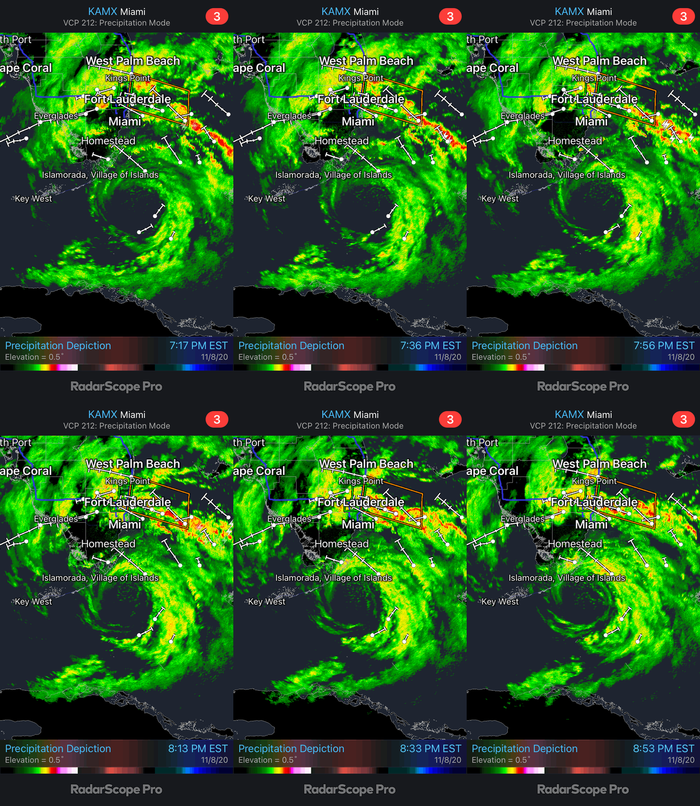
The true eye per radar shows a solid landfall between Layton, Conch Key, Marathon and Islamorada to Key Largo.
-
Looking at radar the LLC still moving in a NW direction. But looking at IR. Sadly you can make out the MLC and it appears to be due west. Its stacked for now.
-
Wonder how much longer the LLC will hang on before opening and broadening? Looking at IR, the Northwest shield is growing.
-
Same thoughts here. But its 2020 and probably also on Friday the 13th.
-
Could get a little dicey around here Thursday into Friday. That's from Tampa following the I4 corridor into Orlando. According to the Hwrf. Edit. Still breezy. But winds have dropped a little since the sun went down.
-
I would not be surprised if the 5pm advisory ETA is labeled as PTC. That dry air did a number.
-
True last few frames of IR are telling. As far as Hwrf is concerned.... Has there ever really been a case like this? Or is this some 2020 weird shyt. Globals decay this storm for the most part. But hwrf has it at a solid cat2. Idk if I ever remember a storm going from tropical to subtropical back to tropical.
-
Wouldn't really say subtropical just yet. A whole lot of dry air to the south, sw, se. But it maybe transitioning https://www.tropicaltidbits.com/sat/satlooper.php?region=29L&product=wv-mid
-
Yeah the models have definitely not handled this storm too well strength wise. Not really looking at globals. But if Hwrf is sniffing something out track wise. Then SSTs are very favorable for further strengthening. May be a major hurricane again once and if it makes another land fall near or north of Tampa Bay.
-
Had some rain bands come through early this morning roughly 4 am. Other wise cloudy. Very thick deck of high level clouds, patchy cumulus clouds. Very impressive wind field with this storm. Not sure exactly but pretty steady breeze of 20-30 mph here in Apopka Nw of Orlando.
-
Pretty windy night. I doubt that with Marco Laura will be as far west though.
-
I've seen it snow in April. A week before was in the 90s. It does happen even though rarely. I was in middle school. I think it was April of 99 or 00. Any way. Kinda of depressing seeing the front stalled in N Fl the last day or so. So close but yet so far. Last good rain we had was on the 5th. That was a surprise.